A History of Observing the Weather
Weather observations, including temperature, moisture, pressure, and wind speed and direction, are the basis for the weather forecasts we rely on every day. NOAA’s National Weather Service has been observing the weather since the 19th century and continues to serve as the primary source of weather data, forecasts, and warnings for the United States.
- Introduction
- The Early Years
- Technological Advances
- Today's Volunteer Observers
- Conclusion
- Works Consulted
Sun, rain, snow, wind...we can't escape the weather, but we can prepare for it if we know what is coming. Checking the daily weather forecast is part of a regular routine for many of us. But have you ever thought about how your local meteorologist actually develops those weather forecasts?
The process of forecasting weather has four elements: observations, analysis, prediction, and dissemination/communications. While we see the end of this process, it is the first element—observations—that serve as the fundamental building block in the weather forecasting process.
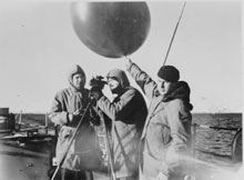
NOAA and its predecessor agencies have been using various instruments to observe the weather since the 1800s. Here, a pilot balloon is launched from a U.S. Coast Guard vessel. Click image for larger view.
Weather observations are collected, quality-controlled, and used in numerical weather prediction models to create forecasts on local to global scales. Without accurate, frequent, current, and comprehensive weather observations, analyses are weak, models/predictions are inaccurate, and the value of weather information to the public and industry is reduced.
The key parameters of weather observations include temperature, moisture, pressure, and wind speed and direction at the Earth's surface and vertically thru the atmosphere. These elements have not changed dramatically since the first weather observations were recorded. The platforms for weather instruments and the methods to disseminate weather information, however, have changed dramatically over the years, both in terms of volume and reliability.
NOAA and its predecessor organizations have been in the business of observing weather since the 1800s. This article looks at the history of weather observations and how increased observational accuracy has led to enhanced forecasting capabilities and ultimately enhanced NOAA's ability to protect lives and property.
Weather Observations in Early American History
The early American colonial years are peppered with events and stories referencing weather observations. The first systematic weather observations in North America were made in 1644 in Wilmington, Delaware, by Reverend John Campanius Holms. Observations of storm movement and weather patterns were first noticed by Benjamin Franklin when he documented the movement of a hurricane from Philadelphia to Boston in 1743. During the signing of the Declaration of Independence, Thomas Jefferson noted that the high temperature for Philadelphia on July 4, 1776, was 76 degrees Fahrenheit (24 degrees Celsius). Presidents such as George Washington and Jefferson were some of the first weather observers in the county. And, during their trip to explore the western U.S. in 1804-1806, the Lewis and Clark expedition made regular weather observations.
Building a Weather Observing Network
The importance of weather observations quickly gained a strong foothold in our young nation. In 1776, Thomas Jefferson began to recruit volunteer weather observers throughout Virginia. By 1800, there were volunteers in five other states, including Massachusetts, Pennsylvania, Connecticut, New York, and North Carolina.
In 1814, Surgeon General James Tilton issued orders for conducting weather observations at Army posts across the country and thus the idea of a weather network was born. The concept of a nationwide weather observing network took a great leap forward when, in 1848, Secretary of the new Smithsonian Institution Jospeh Henry inaugurated a telegraphic network of weather observers "to solve the problems of American storms." Under Henry, 150 volunteers were reporting weather observations using the newly operational telegraph to "forecast" storms. By 1860, 500 stations, manned by volunteers, furnished daily telegraphic weather reports. This volunteer network was the start of something much larger.
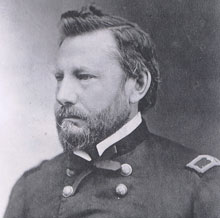
Brigadier General Albert J. Myer was the first Chief Signal Officer of the weather division of the U.S. Army Signal Corps. Click image for larger view.
On February 9, 1870, President Ulysses S. Grant signed a joint resolution of Congress authorizing the Secretary of War to establish a national weather service. Within the Department of War, this weather operation was assigned to the Signal Service Corps under Brigadier General Albert J. Myer. The weather operation was officially called "The Division of Telegrams and Reports for the Benefit of Commerce." Under the direction of General Myer, the first synchronous weather observations were taken on November 1, 1870, at 7:35 a.m., when weather observations at 24 stations were recorded and transmitted to a central site in Washington, DC.
By 1891, the network of volunteer weather observers had grown to 2,000 stations.
Technological Advances
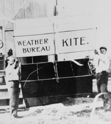
Getting ready to launch a Weather Bureau kite. Click image for larger view.
As the network for gathering weather observations was growing, the government began introducing new technologies to collect and save weather observations. In recognition of the need to make weather observations vertically in the atmosphere, in 1885, Professor Henry Allen Hazen made the first balloon flights to take meteorological observations above the Earth's surface. Shortly thereafter, in 1898, the U.S. Weather Bureau began to experiment with kites to measure temperature, relative humidity, and winds in the upper atmosphere. In 1909, the Weather Bureau began to use balloons for upper air information, a method still in use today.
Observations and Aviation
The advent of aviation changed the Weather Bureau substantially. In 1926, the Air Commerce Act directed the Weather Bureau to provide weather services to civilian aviation. Around this time, weather observations were also being taken by the U.S. Navy and the Weather Bureau from airplanes. Thus, the connection between weather operations and aviation was established.
During the mid-1900s, weather observing technologies started growing at a rapid pace. In 1934, 20 daily aircraft observations were flown by the Weather Bureau and it partners. This program proved to be risky and expensive and was replaced by the pilot-balloon (pibal) program.
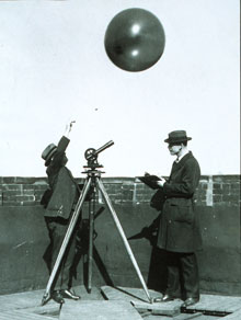
This image shows early testing of hydrogen-filled balloons for radiosonde measurements. The theodolite in the image was used to track the balloon to the limit of visibility. Click image for larger view.
The pibal was replaced by the radiosonde in 1938, a change that allowed weather observations up to 100,000 feet (30 kilometers) to be collected. Radiosondes are units for use in weather balloons that measure various atmospheric parameters, such as air temperature, humidity, and pressure, and transmit information to a fixed receiver on the ground. Additionally, unlike the pibal, the radiosonde could be launched in most types of weather conditions.
A major step in hurricane observations and forecasting took place shortly after World War II, when, on July 17, 1943, Colonel Joseph P. Duckworth and Lieutenant Ralph O'Hair, Army Air Force, made the first known weather observations of a hurricane from an aircraft at an altitude of 5,000-6,000 feet (1,500-1,800 meters). Since this first intentional flight into a hurricane, NOAA has routinely flown into storms that are a threat to the U.S. Today, onboard radar and instruments provide NOAA meteorologists with an unparalleled density of data about hurricanes.
Radar and Satellites
Two new weather observing technologies—weather radar and weather satellites—were developed almost simultaneously during the 1950s. Both technologies were developed to directly support needed weather observations during military campaigns. Today, we refer to weather observations from radar and satellites as "remote sensing." Remote sensing means we can obtain weather observations far from the weather observing technology and greatly expand our weather observing network.
The radar technology originally designed to detect and locate hostile aircraft in World War II served as the basis for the advanced weather radar systems that are saving lives today. Weather radars were first operated by the Army in 1954. The first weather radar was operated by the Weather Bureau in Miami in 1959. Today, NOAA's National Weather Service relies daily on radar to detect, locate, and measure precipitation inside clouds.
The first weather satellite was successfully launched on April 1, 1960. Weather satellites allow us to observe the entire Atlantic and Pacific Oceans in minutes. These new technologies dramatically reduced "weather surprises" by observing the atmosphere more frequently. Today, cloud images collected from these satellites are seen daily on television weather forecasts.
Today's Volunteer Observers
Today, NOAA's National Weather Service depends on volunteer support from the general public to gather weather observations through two key programs: Storm Spotters and the Cooperative Observer Program. In both these programs, volunteers provide vital, real-time observational data to the National Weather Service.
Cooperative Observer Program
The Cooperative Observer Program (COOP) is truly the nation's weather and climate observing network "of, by, and for" the people. More than 11,000 volunteers take observations on farms, in urban and suburban areas, at national parks, along seashores, and on mountaintops. Collected data are truly representative of where people live, work, and play.
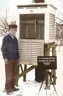
At a cooperative weather station in Granger, Utah, volunteers observed temperature, precipitation, sky conditions, and other variables. Click image for larger view.
COOP's mission is to provide observational meteorological data, usually consisting of daily maximum and minimum temperatures, snowfall, and 24-hour precipitation totals required to define the climate of the United States and to help measure long-term climate changes. Volunteer weather observers conscientiously contribute their time so that observations can provide the vital information needed.
These data are invaluable in learning more about the floods, droughts, and heat and cold waves that affect us all. The data are also used in agricultural planning and assessment, engineering, environmental-impact assessment, utilities planning, and litigation. COOP data also play a critical role in efforts to recognize and evaluate the extent of human impacts on climate from local to global scales.
Storm Spotters
The impacts of severe weather are felt almost every day by tens of thousands of Americans. To obtain critical weather information from a variety of locations, the National Weather Service and partner groups set up Storm Spotters, a volunteer program with more than 230,000 trained severe weather spotters. These volunteers help keep their local communities safe by sending the National Weather Service timely and accurate reports of severe weather.
Storm Spotters volunteers provide essential information for all types of environmental hazards; however, the main responsibility of a spotter is to report severe local storms. In an average year, the U.S. is affected by 10,000 severe thunderstorms, 5,000 floods, and more than 1,000 tornadoes. Where appropriate, spotters also are trained to recognize warning signs for earthquakes; landslides; avalanches; volcanic ashfall; and coastal hazards such as tsunamis, water spouts, and rip currents.
Since the program started in the 1970s, Storm Spotters information, coupled with Doppler radar technology, improved satellite data, and other resources, has enabled the National Weather Service to issue more timely and accurate warnings for tornadoes, severe thunderstorms, hurricanes, and flash floods. Storm Spotters volunteers form the nation's first line of defense against severe weather. The efforts of these volunteers have given communities the precious gift of time—seconds and minutes that can help save lives.
Conclusion
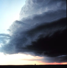
Weather observations play a central role in protecting us from severe weather, such as this supercell thunderstorm, which was spotted in Miami, Texas. Click image for larger view.
The science and technology of weather observations have made great strides and progress during the short history of this country. The progress of weather observations is related directly to the rapid development of technology and a greater scientific understanding of the Earth's atmosphere. Today, weather observations are linked to environmental Earth observations, including measurements of the atmosphere, the oceans, and land surfaces. The observing program is diverse, ranging from very complex technologies such as weather satellites to basic instruments such as the thermometer used by volunteers in their backyards. Improvements in the accuracy and reliability of daily weather forecasts to the public and American industries are directly tied to better and more frequent weather observations. All of this leads to a safer general public and a stronger national economy.
Works Consulted
Dutton, J. A. (2002). Opportunities and priorities in a new era for weather and climate services, Bulletin of the American Meteorological Society, September 2002, volume 83, no.9, pp 1303-1311.
Hughes, P. (1970). A Century of Weather Service. Gordon and Breach Science Publishers, Inc. (New York). 212 pp.
National Oceanic and Atmospheric Administration. (1979). The Amateur Weather Forecaster, (Washington DC). 7pp.
Rosenfeld, J. (1995). Weatherwise. Heldref Publications, (Washington, DC).
90 pp.
