General Myer: Establishing a Legacy of Weather Service
NOAA's National Weather Service is the primary source of weather data, forecasts and warnings for the United States. Television weathercasters and private meteorology companies prepare their forecasts using this information. NOAA is also the sole United States official voice for issuing warnings during life-threatening weather situations.
- Introduction
- Early Weather Observations
- U.S. Army Signal Corps
- An Expanding Presence
- The Next Century
- Conclusion
Today, NOAA manages a network of thousands of weather observations, made hourly and daily by government agencies, volunteer observers, ships, planes, automatic weather stations, and Earth-orbiting satellites. These observations provide the information to develop the weather forecasts and warnings we count on everyday.
The roots of this weather observation network goes back to the 1800s and the innovative mind of Brigadier General Albert J. Myer. As the first Chief Signal Officer of the weather arm of the U.S. Army Signal Corps, General Myer laid the foundation that would carry the National Weather Service from its Army roots to a federal agency in the mid-1970s, poised for a rapid scientific and technological transformation.
Starting with the achievements of General Myer, this article traces NOAA National Weather Service's 150-year legacy of delivering weather information to the American people.
Early Weather Observations
During the 1800s, the weather observation network began to grow and expand across the United States. In 1848, Joseph Henry, Secretary of the new Smithsonian Institution, suggested a system of weather observers across the continent, who would use the newly operational telegraph to "forecast" storms. By 1860, 500 stations, manned by volunteers, furnished daily telegraphic weather reports. This volunteer network was the start of something much larger.
The U.S. Army Signal Corps
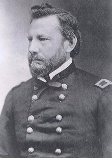
Matthew Brady’s portrait of General Albert J. Myer, the first Chief Signal Officer of the weather division of the U.S. Army Signal Corps. Click image for larger view.
Understanding the value of weather forecasts to a growing America, on February 9, 1870, President Ulysses S. Grant established a national weather forecasting capability. This required the Secretary of War "to provide for taking meteorological observations at the military stations in the interior of the continent and at other points in the States and Territories...and for giving notice on the northern (Great) Lakes and on the seacoast by magnetic telegraph and marine signals, of the approach and force of storms."
Based on this guidance, on November 1, 1870, Brigadier General Albert J. Myer established a weather-warning network under the U.S. Army Signal Corps, called the Division of Telegrams and Reports for the Benefit of Commerce.
Getting the Word Out
Three times daily, Army Signal Corps field stations telegraphed basic weather observations to headquarters in Washington, D.C. Once the Signal Corps made forecasts and rudimentary storm warnings, the information was distributed to observers, railroad stations, and available news media. They worked under the assumption that weather occurring at one location would move to the next area "downstream."
No other organization possessed the capability to observe and report weather systems like the Signal Corps. Members of the Signal Corps could view and report storms from different perspectives at the same time. Using the telegraph system, accurate warnings traveled faster than the storms themselves, allowing people to get out of harm's way.
Storm warnings were delivered by Myer's patented "wig-wag" flag system. Upon receiving word by telegraph that a storm was heading their way, a flag was raised to warn the public about impending severe weather. Today, Myer's red flag with a black square in the center continues to warn coastal communities of impending tropical storms and hurricanes.
A Growing Service
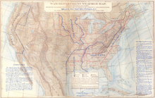
General Myer’s division of stations for weather purposes. Rather than dividing the U.S. into ten administrative departments, as the Army did, General Myer grouped stations by common climate and geography. Click image for larger view.
What began as a regional weather-warning network to prevent the loss of life and property in the Great Lakes region rapidly grew into a national weather service. Local and national newspapers published weather bulletins, which were displayed at post offices, train stations, telegraph offices, boards of trade, and chambers of commerce. As many as twenty offices under Myer's supervision published detailed maps and charts. By 1873, 89 weather stations ringed North America.
Volunteer observers soon joined lighthouse keepers and life-saving personnel in rescuing crews of stranded ships along the East coast of the United States. Connected by newly constructed Army telegraph lines, the East coast became the world's best-protected shipping lane.
Recognizing that the workload was too much for one person, Professor Cleveland Abbe was hired in January, 1871, and his expertise contributed a great deal to further the science of meteorology.
An Expanding Presence
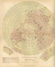
Dated October 1, 1877, this map was produced by General Myer’s division in Washington, DC. The map is based on daily synchronous weather observations made in the U.S., Europe, and ships at sea. This map is a testament to the cooperation Myer received around the world and his commitment to creating an international weather observation network. Click image for larger view.
The weather division of the Signal Corps assumed an international dimension when General Myer attended the First Congress of the International Meteorological Organization (IMO) in Austria in 1873.
Foreign countries adopted the practice of taking simultaneous observations coordinated by telegraph, perfected by the United States three years earlier. General Myer's proposal to initiate global synchronous observations passed unanimously at the IMO meeting. In 1875, observations became the basis for daily international weather bulletins, published by Myer's division in Washington, D.C.
Expanding the Network and Application of Weather Observations
By the mid-1870s, Myer's Weather Bureau also relied upon weather observations submitted by 383 volunteer civilian observers, previously employed by the Smithsonian Institution. The network of weather observations continued to grow.
U.S. warships began to carry weather instrumentation and report daily observations to Myer's division. Additionally, numerous foreign and domestic commercial steamship companies telegraphed weather data to Washington, D.C. These data were only sent when ships docked, since there was no wireless telegraphy at the time.
With so much data from so many sources, it became possible to study weather systems, to better understand and predict their movement from one continent to another. As a result, ship captains transiting the Atlantic Ocean could more effectively anticipate severe weather.
In the interior of the United States, riverboat pilots operating on the Ohio, Mississippi, Missouri, and Monongahela rivers received updates on water levels and currents posted by Myer's sergeants. Boats could continue their work without having to wait for weather information to appear in newspapers.
Scientific Achievements & Growth
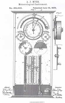
General Myer was also an inventor. In 1879, he received a patent for a weather instrument that combined an anemometer, barometer, thermometer, and hygrometer with two dials that indicated whether conditions favored dry or wet weather. Click image for larger view.
In addition to leading the Signal Service, Myer was a scientist and inventor. His commitment to science was evident in the five upper air stations he opened during his tenure as Chief Signal Officer. These stations collected atmospheric data through weather balloons.
Myer's Division claimed an 88.4 percent forecast verification rate, which is astonishing because, at that time, there were no Doppler radars, geostationary satellites, computerized forecast models, radiosondes, or automated river gauges. The Division's warnings reached more than 30 million Americans before the advent of radio, television, telephone, or the Internet.
General Myer was considered a hero because he started his career as an Army Assistant Surgeon, and so understood the risks he took with his own health and life in order to safeguard others. Myer passed away from overwork in his hometown of Buffalo, New York, one month before his 52d birthday. From his legacy, today's National Weather Service eventually arose.
The Next Century: Building on Myer's Foundation
In 1891, the Weather Bureau passed from military to civilian control and was moved to the Department of Agriculture, where it remained until 1940. During this time, the Weather Bureau's national network of offices staffed by government forecasters continued to grow and explore new technologies to collect and deliver weather information to the public.
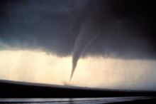
In 1952, a Severe Local Storms unit was established within the Weather Bureau. Their first tornado forecast, issued on March 17, 1952, called for tornadoes in east Texas, south Arkansas, and Louisiana. The forecast was close, but not perfect: tornadoes did occur in north central Texas, but not in Arkansas or Louisiana. Click image for larger view.
Realizing that the Weather Bureau played an important role in aviation, and therefore commerce, in 1940, President Franklin D. Roosevelt transferred the Weather Bureau to the Department of Commerce. By the early 1950s, the Weather Bureau had established a Severe Weather Unit to monitor the nation's weather patterns and prepare "severe weather discussions." These publications gave local weather offices a sense of when there was potential for severe weather.
New Developments
In the late 1950s and early 1960s, new tools such as satellites, computers, and high-speed communications made it possible to explore the physical environment across the globe. It is now possible to communicate, process, analyze, disseminate, and store weather and environmental data in ways like never before. The computing power and modeling capabilities of the 20th century increased lead times and accuracy for weather forecasts and warnings.
The Formation of NOAA
In 1970, the need for expanded environmental services, including improved weather forecasts and warnings, spurred the creation of NOAA within the Department of Commerce.
NOAA brought together the environmental arms from several federal agencies, including the Weather Bureau, which was renamed the National Weather Service.
The Weather Service's long history of protecting lives and livelihoods soon took on new urgency, which carried the agency through a series of catastrophic severe weather events and major technological and scientific improvements over the next 30 years.
The expansion of observing systems during this period of time was critical to set the stage for the National Weather Service's ability to improve weather forecasts, watches, and warnings, and a burgeoning climate forecast capability.
Conclusion
The roots of NOAA's National Weather Service run deep in 19th century science and policy. The agency has moved from a national network of weather observers under the Army Signal Corps, to today's National Weather Service, which relies on sophisticated technology such as satellites, radars, communication systems, and automated weather observing systems.
Throughout its history, the National Weather Service has maintained a tradition of accuracy, technological innovation in weather observations, and devotion to duty.
