From Kites to Satellites: A History of Weather and Air Research at NOAA
Although people have been fascinated by weather and how it impacts human lives for centuries, it was not until the mid- 20th century that technology was developed to measure the composition and processes of the atmosphere, allowing us to reliably forecast weather. Today, NOAA scientists and research partners continue to expand our understanding of the processes that contribute to the world's weather.
- Introduction
- Thunderstorm and Tornado Research
- Hurricane Research
- Air Quality Research
- Conclusion
- Works Consulted
Ben Franklin flew a kite to study lightning and tracked the direction of a big Nor'easter that stormed the East Coast in 1743. George Washington and Thomas Jefferson kept logs of atmospheric conditions each day at Mount Vernon and Monticello. Today, NOAA scientists and their research partners are learning more about the Earth system and the processes that contribute to the world's weather and are developing new prediction tools.

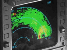
This image of a radar scope was taken on board a NOAA G-IV aircraft during Hurricane Katrina. On the scope, the unmistakable signature of the hurricane eye and eyewall shows up: on the lower-right side of the image, just above and left of the number, is the eye of the storm as seen from 45,000 feet. Click image for larger view.
NOAA conducts research on the upper and lower atmosphere, on the oceans and Great Lakes, and on coastal environments. Findings have enhanced basic understanding of interacting systems and led to improvements in services provided by NOAA, from severe storm warnings to protection of our nation's coasts. Other NOAA research programs focus on the study of the chemical and physical processes of the atmosphere, detecting the effects of pollution on those processes, and monitoring and forecasting the phenomena affecting the sun-Earth environment.
While technology may have changed over time, the need to understand weather patterns and air quality has remained constant. This article takes a look at some of the roles NOAA has played over the years in the pursuit to understand our atmosphere, specifically related to thunderstorm and tornado, hurricane, and air quality research.
Thunderstorm and Tornado Research
Today, NOAA's National Severe Storms Laboratory (NSSL) studies many aspects of thunderstorms, from damaging winds to hail, lightning, and tornadoes. NOAA uses modeling, direct observation through field studies, and past weather data to improve understanding of when and where severe weather will occur.
The history of this research dates back to 1964, with the establishment of the NSSL in Norman, Oklahoma. This small group of researchers would forever change forecasting by improving knowledge of thunderstorms and developing new meteorological tools.
WSR-57 Surveillance Radar

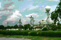
WSR-57 radar worked by sending out short bursts of energy in a beam that came from a slowly rotating antenna. Click image for larger view.
Part of NSSL’s initial role was to maximize the use of the WSR-57 Surveillance Radar for the Weather Bureau. This radar worked by sending out short bursts of energy and measuring the size of the energy that bounced back. NSSL engineers made it possible to “see” the strength of the returned energy by creating a contoured black and white display. The Weather Bureau and most other radar users quickly adopted this technology because it provided more detailed information about storm strength.
Throughout the 1960s, NSSL conducted aircraft studies of turbulence in severe thunderstorms. Called Project Rough Rider, these experiments involved researchers flying into thunderstorms to measure turbulence, while the WSR-57 radar was monitoring the storms continuously. This research led to improved commercial airline safety guidelines in the vicinity of thunderstorms that are still in use today.
During its early years, NSSL also conducted a data collection program each spring designed to improve understanding of severe storms. These field programs increased our knowledge of the processes that create severe weather and the behavior of storms and ultimately led to more accurate and timely forecasts and warnings.
Doppler Radar
In the late 1960s and early 1970s, the NSSL developed one of the first Doppler weather radars. Doppler radar uses radio waves to create pictures showing the location and intensity of precipitation. Doppler radar allowed scientists to measure motion inside storms for the very first time, providing valuable clues into the development of severe weather.
Using this radar, scientists also discovered that when a tornado begins to form, its winds blow raindrops in a signature pattern on the radar screen. In May of 1973, a devastating tornado tore through a small town just west of Oklahoma City. For the first time, Doppler radar and storm intercept teams documented the entire life cycle of the tornado. In reviewing the data, researchers discovered a small-scale Doppler velocity circulation appeared aloft even before the tornado descended to the ground—a feature that would allow forecasters to better warn the public of impending danger.
Additional research on thunderstorms led to the Joint Doppler Operational Project (JDOP), which tested the warning potential of the Doppler radar. JDOP conclusively showed that Doppler radar had the potential to assist in issuing more accurate warnings, and more importantly, warnings with enough lead time for the public to find safe shelter.
Hurricane Research
Hurricanes are among the most powerful and destructive of natural phenomena faced by humankind. A single storm can produce 200 times the daily world electricity generating capacity.
The U.S. government began monitoring hurricanes after World War II, with military planes flying reconnaissance missions into tropical cyclones to help warn people of impending landfall. A hurricane forecaster, working for what was then the U.S. Weather Bureau in Miami, used these reconnaissance missions to collect scientific measurements of these storms.
In the mid-1950s, when several hurricanes – notably Carol, Edna and Hazel – hurled up the East Coast, policymakers in Washington, DC, took notice and initiated formal funding of hurricane research.
The National Hurricane Research Project

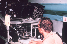
A radar technician sits at a radar scope. Click image for larger view.
The National Hurricane Research Project (NHRP) was started in 1955. Researchers began flying into hurricanes with instruments to measure temperature, humidity, and pressure and to punch collected data on computer cards. Photos taken of an on-board radar scope provided radar data to study later. These measurements helped researchers get a picture of the three-dimensional structure of hurricanes and the upper- and mid-level winds thought to steer the storms.
In 1958, 23 missions were flown, and hurricane science was advanced with the subsequent publication of papers on mean atmospheric soundings, hurricane rainfall distributions, storm surge surveys, and radar descriptions of hurricane structure. The next year, the Hurricane Research Project moved to the Miami hurricane forecast office, which later became known as the National Hurricane Center (NHC).
The research component of the Hurricane Project was formalized as the National Hurricane Research Laboratory and it became part of a string of labs across the country studying environmental science.
Weather Satellites

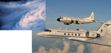
Armed with satellite imagery, “hurricane hunters” fly airplanes like the NOAA WP-3 and Gulfstream-IV directly into hurricanes to collect valuable data about the nature of the storms. Click image for larger view.
The launching of the first weather satellites had a dramatic impact on hurricane research in the 1960s. They eliminated the need to send aircraft out to scout for signs of tropical disturbances. With satellite pictures, forecasters could pinpoint where “hurricane hunters” needed to fly.
Now, 40 years after the first satellites took pictures of hurricanes, NOAA scientists realize there is still much to learn about these storms. Scientists take to the skies every hurricane season, capturing measurements to help understand and predict the path and intensity of these destructive storms.
Air Quality Research
Everyone wants and deserves clean air to breathe, and the U.S. Clean Air Act has established national air quality goals for the protection of human health and welfare. The quality of the air is the result of a complex interaction of many factors that involve the chemistry and motions of the atmosphere, as well as the emissions of pollutants from sources that are both natural and anthropogenic. NOAA's research scientists have been working to understand the atmospheric factors that are responsible for poor air quality since the 1940s.
Radioactive Fallout
The emergence of the nuclear age in the 1940s created unease about the long range transport of radioactive fallout. Concerns quickly grew about how these chemicals in the atmosphere would interact with other aspects of the environment. In 1948, the Weather Bureau formed the Special Projects Section, which later became the Air Resources Laboratory (ARL), to research these issues using meteorological research on the dynamics, components, and processes that govern the atmosphere.
Stratospheric Ozone
During the 1970s, the atmospheric science community was increasingly interested in climate change, specifically the possibility of global cooling and ozone depletion due to air pollution and jet emissions. Ozone is naturally present in the atmosphere, but in elevated amounts it is damaging to the living tissue of plants and animals.
ARL scientists began to monitor stratospheric ozone levels using data from a global network of ground-based sensors. This work played a large part in development of the global ozone network, which greatly enhanced our understanding of stratospheric ozone properties and levels.
ARL Today
Today, ARL serves as a leading source of atmospheric transport and dispersion capabilities. However, the early focus on the prediction of concentrations downwind of a specific emission source (e.g., a nuclear test) has grown and ARL’s dispersion skills have broadened to include things such as tracking soot from an erupting volcano or predicting how and where the plume from a chemical spill will travel.
Out of the early awareness that radioactive fallout was a global issue grew the current activities related to climate and global change. From the need to consider the chemistry of pollutants arose the present emphasis on air quality and its prediction. And from the recognition that humans could affect the atmosphere on global scales came the ARL emphasis on climate and methods to detect changes in it.
Conclusion
NOAA’s history of weather research for improved prediction and forecasting is as dynamic as the systems we study. Research on severe weather and air quality described above are just a sample of the important work NOAA scientists have accomplished over the years.
Today, NOAA’s weather research largely occurs under its Office of Oceanic and Atmospheric Research, where dedicated scientists continue to explore new and improved ways of understanding and predicting environmental change. The research is used throughout NOAA to help expand our knowledge of natural systems and how they interact, shed new light on the processes that contribute to the world's weather and influence air quality, and develop new tools and improve others for better predictions.
No one can prevent the weather, but greater understanding of it can help save lives and property throughout the world.
Works Consulted
Air Resources Laboratory. (2006). History of the Air Resources Laboratory. Retrieved October 10, 2006, from: http://www.arl.noaa.gov/history.html.
Atlantic Oceanographic and Meteorological Laboratory. (2006). Hurricane Research Division history. Retrieved October 10, 2006, from: http://www.aoml.noaa.gov/hrd/hrd_sub/beginning.html.
National Severe Storms Laboratory. (2004). National Severe Storms Laboratory 40th Anniversary Celebration Web site. Retrieved October 10, 2006, from: http://www.nssl.noaa.gov/40thanniversary/.
