More Observations + Better Models =
Faster Warnings, More Accurate Tracking, Improved Forecasts
NOAA Research, the research and development arm of NOAA, conducts research to provide the nation with better weather forecasts, earlier warnings for natural disasters, and an overall greater understanding of our oceans, climate, and atmosphere. This research helps prepare the nation for the new challenges of tomorrow as society and natural surroundings continue to change.
As NOAA scientists delve into the "how's" and "why's" of natural phenomena—from weather to waves, rivers, and glaciers—they've discovered that seemingly separate natural systems are actually parts of a single system...the Earth system.
Researchers studying the hydrosphere (water, including where it is and where it goes), for example, know that water interacts with the atmosphere, which in turn is affected by the biosphere (living things, from trees to algae), as well as the cryosphere (ice and snow, from glaciers to icebergs). But none of these spheres can be studied in isolation. Current and future characteristics of one sphere are dependent on the characteristics of all the others.
Furthering this new understanding will require new and better observations of the Earth system, leading to improved modeling capabilities. The result will be more accurate and timely warnings of impending destructive natural events for our communities.
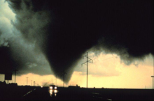
Research on savage weather phenomena like tornadoes helps scientists understand these storms better, which leads to better models - and more accurate and timely warnings. More warning time saves lives and helps to protect property. Click image for larger view.
Each year, thousands of lives and dollars are lost to severe storms, flooding, heat waves, and other natural events. Excluding extreme events like Hurricane Katrina, losses due to severe weather in the United States total over $10 billion annually. Poor air quality is even more costly, causing an estimated 40,000 deaths each year and up to $150 billion in health and other expenses.
This article looks at where NOAA is heading in conducting the research needed to preserve the health or life of each individual and to help mitigate damage to coastal areas. As the problems grow, so too do the stakes. NOAA researchers are ready and able to take up the challenge.
More Observations: Taking the Pulse of the Planet
Currently, observing systems at NOAA measure more than 500 environmental parameters on platforms ranging from geostationary and polar-orbiting satellites and weather balloons to ships and airplanes, ocean buoys, and submersible vehicles. However, NOAA has now embarked on a mission to take the pulse of the entire planet.
NOAA and partners are working in the U.S. and abroad to develop a Global Earth Observation System of Systems (GEOSS). The goal is not simply to "plug the holes" and fill the gaps in current observing systems. Rather, the goal is to coordinate across local and global scales, and among nations, to develop a system that covers the full spectrum of environmental phenomena—from the surface of the sun to the depths of the ocean—and to ensure the various components can speak to and understand each other.
NOAA will be integral in developing, improving, and integrating observations needed to understand the natural world and produce better forecasts and warnings in the future. Below are some of the initiatives that NOAA's Office of Oceanic and Atmospheric Research will be pursuing.
Phased Array Radar
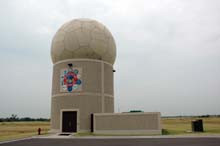
The next step in NOAA's long-time research and advancement of weather radars is phased array radar. Using electronic controls of beams and frequencies, these new radars can scan more quickly, thereby increasing lead times for tornado warnings. Click image for larger view.
NOAA researchers will soon begin adapting state-of-the-art radar technology currently deployed on Navy ships for use in spotting severe weather. "Phased array radar" uses multiple beams and frequencies that are controlled electronically, reducing scan or data collection time from five or six minutes to less than one minute. Reducing scan time produces quicker data updates, potentially increasing the lead time for tornado warnings beyond the current average of 11 minutes. When combined with other technology being developed at NOAA, warning lead times may be extended even farther.
Early tests of the phased array radar system are promising, and the technology has the potential to vastly improve the NEXRAD system for all weather radar applications. The NEXRAD network of weather-surveillance radars figured prominently in National Weather Service modernization, as these Doppler radars were enhanced to embody technology and application advances.
Observing with Unmanned Aircraft Systems
NOAA flies instruments on aircraft to track hurricanes or pinpoint sources and movement of pollution. But there are places that piloted aircraft cannot go, like the thousands of miles of open ocean, thousands of miles from land, or above the inhospitable frigid expanses of the Arctic.
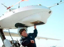
A NOAA researcher conducts preflight tests before flying the Altair Unmanned Aircraft System.
NOAA researchers are taking a close look at Unmanned Aircraft Systems (UAS). UAS are powered aerial systems that do not carry a pilot, but are independently or remotely piloted. They can be land-, air-, or ship-launched and can carry an internal or external payload of scientific equipment. NOAA is testing ways to convert these systems from what is now principally a military use to applications for observing the great, vast Earth system.
Observing with Buoy Systems
NOAA researchers must go where the weather is, so they have developed instruments that can be deployed on airplanes and ships or can be easily transported or placed on tall towers above the landscape. They have altered instruments so they can gather data in the extreme cold. And they are continuing their quest for better, lighter, faster, and more accurate observing systems.
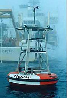
An example of a Deep-ocean Assessment and Reporting of Tsunamis, or DART, buoy. DART buoys have been deployed around the Pacific Ocean to provide warnings of deadly tsunami waves.
When NOAA researchers wanted to collect data below, on, and above the world's oceans, they developed and deployed buoy systems. These "sentinels on the seas" gave scientists information about sea-surface temperatures that led to predictions and tracking of El Niņo events that influence global weather patterns. Another buoy system was developed to detect tsunami waves.
Building, maintaining, and updating observing systems, including buoys, is a priority of NOAA and part of the proposed GEOSS. If UAS can be deployed in the remote oceans, providing data previously unavailable, buoys will be instrumental in capturing a vertical profile of conditions from the bottom of the ocean to the top of the atmosphere, and everything in between. This information can lead to improved models of conditions over vast oceans.
Observing with Satellites
While scientists have successfully used data from satellites for nearly 50 years, the satellite program at NOAA is growing and changing as data needs grow and change. One of the recent instruments developed by NOAA is the "SXI imager" on a geostationary satellite that sends x-ray images of the sun to Earth in near real-time.
This new instrument is proving very helpful to NOAA forecasters who monitor the sun 24/7 to report conditions and to warn of storms that can wreak havoc on power, communication, and navigation systems on Earth. The x-ray image of the sun gives forecasters a good look at solar storms, and improved observations of these storms can lead to better understanding and eventually to improved ability to predict when they may burst out of the sun.
Better Models: Predictions for the Future
If they could look into a crystal ball and see the scientific advances of the future, NOAA scientists would hope for a model of the whole Earth-system. To predict and understand the chemistry, dynamics, interactions, and chaotic changes that can affect the entire Earth, researchers must develop a model that represents the entire the environment. Doing so is crucial to providing more accurate weather forecasts and better understanding of air quality.
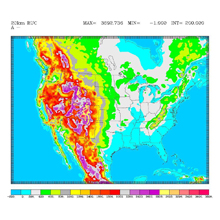
Rapid Update Cycle (RUC) is a numerical forecast model with an analysis/assimilation system that can frequently update short-range weather forecasts for users such as aviation and severe weather forecasters. This map, generated using RUC, is more detailed than maps created using earlier models. Click image for larger view.
However, understanding and measuring everything there is to know about the Earth and its environment is not a simple task. Even if NOAA researchers deployed a fleet of unmanned aerial vehicles, greatly improved observing instruments and platforms, and completed the global observing system, assembling an accurate, detailed picture of the Earth, scientists would still have more work to do to construct the model.
Advanced Data Simulation Techniques
The first step in constructing an Earth-system model is to develop advanced data simulation techniques to ensure maximum value is extracted from the data. To do this, developers will improve model analyses and the initializing, or testing and evaluating, of models. Also, models will be designed that do a better job of simulating clouds and the effects of varying terrain. And, models must be able to represent the processes that link the atmosphere, water, land, and space.
Developers know that new models will incorporate global-scale data from satellites and other collection points. They recognize the need to bring in an Earth-system framework and apply new physics to initially describe the system.
Community Model Approach
A "community model approach" will be used to improve forecasts. NOAA researchers will couple numerical modeling systems so that weather, air quality, water, climate, and other geophysical phenomena—and their interactions—are adequately represented.
To get a true handle on the uncertainty in models, researchers want to improve probabilistic prediction capability. To do so, they are working on "ensemble modeling techniques," running several models collectively and averaging the results to select the most likely eventuality. NOAA will be partnering with modeling centers around the world to achieve the most accuracy possible from these ensemble efforts.
NOAA wants to improve the accuracy of one- to 14-day weather forecasts, especially predictions of where and how much precipitation will occur and more advanced notice of winter storms and their intensity. To do this, NOAA is collaborating with the meteorological research community to develop test beds that marry research and operational forecasting capabilities, focusing the efforts on particular regions and types of weather events.
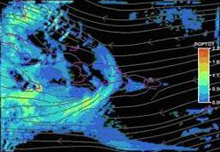
Pictured is a 12-hour rain forecast produced by the Weather Research and Forecasting (WRF) model. The WRF model increases accuracy and specificity of weather forecasts by incorporating more data points and more detail.
To improve the models and forecasts of where and when hurricanes will surge ashore, NOAA researchers are working to improve the hurricane forecast system. The future will see higher-resolution hurricane models to study the fundamental dynamics of hurricane genesis, structure, and motion. NOAA researchers are also investigating hurricane sensitivity to climate change.
Global weather models are crucial to improving all of these medium-range predictions. These models will also help evaluate the value of observations by simulating subsystems of the global observing system.
Faster Warnings, More Accurate Tracking, Improved Forecasts
Ultimately, if more observations and better models are to lead to faster warnings, more accurate tracking, and better forecasts, we need a better understanding of the whole Earth-system. In the next 20 years, NOAA researchers hope to answer questions such as:
- Why do some super cell thunderstorms spawn tornadoes, while others do not?
- How are hurricanes formed, and what causes rapid intensification at landfall?
- Where is a hurricane headed, and can we forecast its precise track three days ahead of time rather than 12 hours?
- How can precipitation location and amounts be pinpointed to forecast flooding events?
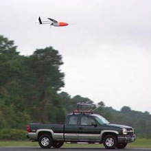
An aerosonde unmanned aerial vehicle is released from its transport vehicle on the runway at the National Aeronautics and Space Administration Wallops flight facility in Wallops Island, Virginia, on September 16, 2005. The aerosonde flew into Hurricane Ophelia to take measurements of pressure, wind speed, and other factors.
NOAA researchers are already hard at work determining the amount and type of data needed to address these gaps in our knowledge. They are designing cost-effective ways to observe the sun, space, atmosphere, land, water cycle, life, and oceans to improve their forecasts.
NOAA will also work to improve its future computing capability, to take in, digest, and use more and better data collected through global observations. NOAA is developing high-performance computing resources to support advances in environmental modeling capabilities.
Researchers will design and run models and migrate these as quickly
and efficiently as possible to operational weather and climate
models, to improve the nation's weather forecasts, including
hurricane forecasts and severe weather forecasts, as well
as to improve seasonal drought forecasts and to reduce the
uncertainties in long-range climate predictions.
Contributed by Carol Knight, NOAA's Office of Oceanic and Atmospheric Research, and Keli Tarp, NOAA Office of Public Affairs
