
 Great Theodolite
 The Bache- Wurdemann Compensating Device
 Eimbeck Duplex Bars
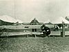 Iced Bar B 17
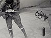 Steel Tape with Tape Stretcher
 Invar Tape
 AGA Geodimeter NASM-2A
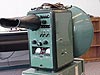 Tellurometer Model M/RA 1
 Laser Signal and Prismatic Mirror Reflecting System
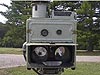 AGA Geodimeters, Models 4D and 4L
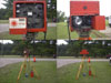 Big Red
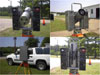 AGA Geodimeter Model 6
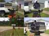 Hewlett-Packard Model 3800B Distance Meter
 Tellurometer Model MA-100
 Ranger III and Rangemaster III
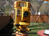 Topcon ET-1 Total Station
 Trimble GPS Antenna
Topcon ET-1 Total Station
The Topcon ET-1 Total Station combined an instrument for measuring distances with an instrument for measuring angles, so that both measurements could be taken by the same instrument. Prior to the advent of total stations, separate instruments were needed to measure distances and angles.

Photo courtesy of Bujor Tanasescu.
Among the refinements for electronic distance measure instruments (EDMI) were electronic data recording devices that accepted data directly from the instrument and allowed for downloading to a variety of devices. Eventually, the need for separate instruments for measuring angles and distances was ended with the introduction of the total station, which combines a theodolite and an EDMI.
The National Geodetic Survey Aeronautical Survey Program obtained its first total station, a Topcon ET-1, in 1985. When the distance range on the total station models improved sufficiently, use of stand-alone EDMI for airport surveys ended.
Currently, a total station, which allows for distance measurements of up to 3,900 feet (1,200 meters) without a reflector, is being tested and evaluated. A hand-held, reflector-less laser made by Riegl is also used by the Aeronautical Survey Program to measure distances to airport obstructions such as tops of trees.
Distance Measurement Instrument Shown: Topcon ET-1 Total Station- Location: British Columbia, Canada
- Manufacture Date: 1985
- Dates of Use: 1980s
- Photo Date: 2006?
Works Consulted
UNSW Virtual Surveying Instrument Collection (2000). lectronic Tacheometer. Retrieved June, 2006, from: http://www.gmat.unsw.edu.au/currentstudents/ug/projects/f_pall/html/e19.html.
Related West Sites
Smithsonian Virtual Surveying Instrument Collection