
 Great Theodolite
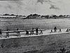 The Bache- Wurdemann Compensating Device
 Eimbeck Duplex Bars
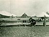 Iced Bar B 17
 Steel Tape with Tape Stretcher
 Invar Tape
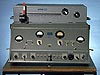 AGA Geodimeter NASM-2A
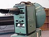 Tellurometer Model M/RA 1
 Laser Signal and Prismatic Mirror Reflecting System
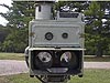 AGA Geodimeters, Models 4D and 4L
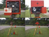 Big Red
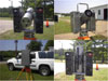 AGA Geodimeter Model 6
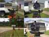 Hewlett-Packard Model 3800B Distance Meter
 Tellurometer Model MA-100
 Ranger III and Rangemaster III
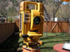 Topcon ET-1 Total Station
 Trimble GPS Antenna
Trimble Global Positioning System Antenna
The Trimble global positioning system (GPS) antenna shown in the photo is one example of the type of antenna used by the National Geodetic Survey to receive satellite signals that are used to determine locations on the Earth’s surface. When used according to standardized procedures, GPS receivers can determine positional coordinates to centimeter-level accuracy anywhere on the surface of the Earth.

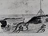
Early morning GPS observations at the water gap at Harpers Ferry, West Virginia. Photo courtesy of Roy Anderson.
The National Geodetic Survey (NGS) performed its first global positioning system (GPS) survey in 1983. An outgrowth of the Navy's Doppler satellite program, GPS determines station location by signals sent from a constellation of satellites to receivers, such as the Trimble GPS antenna, at survey stations rather than by angles and distances measured on the ground. It has largely, although not entirely, replaced total stations, electronic distance measurement instruments (EDMI), and theodolites for the agency's geodetic work.
Historical Reference
Just as it once tested and calibrated bars, tapes, and EDMI in the past, NGS now tests and calibrates GPS equipment. The Corbin, Virginia, office maintains a GPS antenna testing facility, providing the antenna calibration results online to users. NGS’ work with the GPS-based Continuously Operating Reference System (CORS) has made it a leader in the GPS community.
But how does the accuracy of surveys from 150 years ago compare to those made using GPS? In 1992, a three-man crew from the South Carolina Geodetic Survey used GPS to measure a length of 10,721.362 meters for the Edisto Base, originally measured by Superintendent Alexander Bache using the Bache-Wurdman device. The length obtained in 1850 was only 0.061 meters different from the GPS value. The 1850 observations required a month to clear and grade the base line, 13 days of observations, and a crew of 10 people. The 1992 observations took three people about an hour to complete.
- Distance Measurement Instrument Shown: Trimble Global Positioning System Antenna
- Location: Harper’s Ferry National Historic Park, West Virginia
Dates of Use: Present - Photo Date: 2003
Works Consulted
Defense Mapping Agency (1984). Geodesy for the Layman [Electronic Version]. Washington, DC: Defense Mapping Agency.
Miller, S. Edisto’s Marvelous Line. Unpublished.
Related Web Sites
National Geodetic Survey GPS Antenna Calibration
National Geodetic Survey Continuously Operating Reference Station