
 Great Theodolite
 The Bache- Wurdemann Compensating Device
 Eimbeck Duplex Bars
 Iced Bar B 17
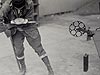 Steel Tape with Tape Stretcher
 Invar Tape
 AGA Geodimeter NASM-2A
 Tellurometer Model M/RA 1
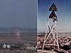 Laser Signal and Prismatic Mirror Reflecting System
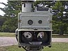 AGA Geodimeters, Models 4D and 4L
 Big Red
 AGA Geodimeter Model 6
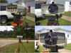 Hewlett-Packard Model 3800B Distance Meter
 Tellurometer Model MA-100
 Ranger III and Rangemaster III
 Topcon ET-1 Total Station
 Trimble GPS Antenna
Steel Tape with Tape Stretcher
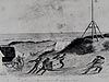
This photograph shows a surveyor using a tape stretcher. In the early 1900s, tapes eventually replaced the bar apparatus as the practical means for measuring distances.
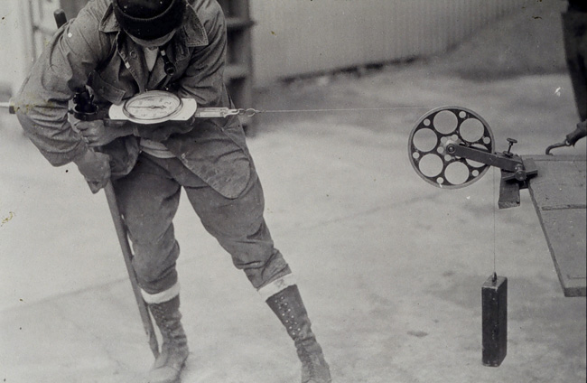
The tape stretcher assembly and its scale provided a means for maintaining consistent, known tension on tapes during measurements. The first tape stretcher built weighed 45 pounds.
Investigation of the use of long steel tapes for the measurement of distances began in 1890. While the tapes themselves were lighter and less bulky than the rod assemblages that were used earlier to measure distances, use of a tape measure was not simply a matter of pulling a tape out and making a measurement. The tapes had to be stretched and aligned consistently. This required the building of an apparatus that included a tape stretcher, to enable the crew to pull the tape with a known amount of force, a breaking link just in case too much pull was accidentally applied, and suspended thermometers to measure temperature and allow accounting for any heat-related expansion to the metal tape.
The tapes were supported by stakes placed at equal intervals and aligned by a theodolite - a survey instrument used for measuring angles. Measurements were made at zinc-capped marking stakes marked by a sharp awl. Because heat from sunlight caused steel tapes to expand, measurements had to be made at night, with the crew communicating its movements by a defined set of whistles.
This system was thoroughly tested in 1891 and 1892, and was used, along with Eimbeck duplex bars, in 1900 at base lines along the 98th meridian. The 1900 work showed that the use of tapes was considerably cheaper and faster than the bar apparatus.
- Distance Measurement Instrument Shown: Steel tape with tape stretcher
- Location: Unknown
- Manufacture Date: 1890s
- Dates of Use: Late 1800s - Early 1900s
- Photo Date: Unknown
Works Consulted
Baldwin, A. L. (1902). On the Measurement of Nine Bases along the Ninety-Eighth Meridian [Electronic version]. Report of the Superintendent of the Coast and Geodetic Survey Showing the Progress of the Work from July 1, 1900, to June 30, 1901, p. 229-302.
Mosman, A. T. (1892). On the Measurement of the Holton Base, Holton, Ripley County, Indiana, and the St. Albans Base, Kanawha County, West Virginia [Electronic Version]. Report of the Superintendent of the Coast and Geodetic Survey for the Fiscal Year Ending June 30,1892, Part II, p 329-503.
Related Web Sites