
 Great Theodolite
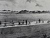 The Bache- Wurdemann Compensating Device
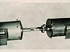 Eimbeck Duplex Bars
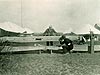 Iced Bar B 17
 Steel Tape with Tape Stretcher
 Invar Tape
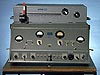 AGA Geodimeter NASM-2A
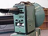 Tellurometer Model M/RA 1
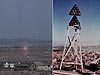 Laser Signal and Prismatic Mirror Reflecting System
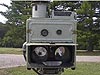 AGA Geodimeters, Models 4D and 4L
 Big Red
 AGA Geodimeter Model 6
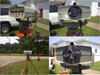 Hewlett-Packard Model 3800B Distance Meter
 Tellurometer Model MA-100
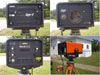 Ranger III and Rangemaster III
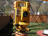 Topcon ET-1 Total Station
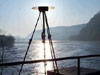 Trimble GPS Antenna
Tellurometer Model MA-100
The Tellurometer Model MA-100, shown in the photo, is a surveying instrument specifically designed for measuring short distances with high accuracies. The MA-100 used infrared light as its signal source and was the first electronic distance measurement instrument used on the National Geodetic Survey calibration base lines program.

The MA-100 shown is missing its top-mounted sighting telescope and its control panel cannot be seen. Photos courtesy of the University of New South Wales School of Surveying and Spatial Information Systems Virtual Surveying Instrument Collection.
The Tellurometer Model MA-100, which used infrared light as its signal source, was the first model produced by Tellurometer that did not use microwaves as the signal source. The MA-100 was used for a range of purposes, from precise traversing, to mining and constructional surveys, to control for aerial photography. It could measure distances of up to 1.9 miles (3.0 kilometers) with an accuracy of a few millimeters.
Historical Reference
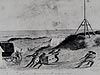
Measurements made using electronic distance measurement instruments (EDMI) were affected by a variety of meteorological conditions as well as reductions in the efficiency of the electronic and mechanical components of instruments over time. As EDMI gained in popularity and availability, the need for a method of checking and calibrating the instruments also grew. In 1963, the Coast and Geodetic Survey used high-precision taping techniques to measure a multi-monumented line in Beltsville, Maryland, for use in EDMI calibration. Although open to all surveyors, the line was mostly used by federal agencies.
In 1974, the National Geodetic Survey (NGS) began a program of establishing calibration base lines (CBL) for standardizing instruments throughout the U.S., in cooperation with various government agencies, universities, and professional societies. Even today, NGS provides instructions and assistance in establishing the base lines, provides software for use in determining scale and constant corrections through CBL measurements, and makes the base line data available online.
After four CBLs were established solely by tape, this time-consuming procedure was replaced by one that required the taping of one section and the use of high accuracy, short-range EDMI throughout. The MA-100 was the first EDMI used on the CBL program. Later, an HP 3800B was used, as was a Geodimeter 122.
The present day CBL program uses a Leica DI2002. The MA-100 had a leather carrying handle, but weighed over 38 pounds (17.2 kilograms) compared to the DI2002, which weighs a mere 2.6 pounds (1.3 kilograms)!
- Distance Measurement Instrument Shown: Tellurometer Model MA-100
- Location: Collection of the University of New South Wales School of Surveying and Spatial Information Systems, Scotland
- Manufacture Date: 1963
- Dates of Use: 1960s – 1970s
- Photo Date: MA-100: 2000?
Works Consulted
Dracup, J. F, Fronczek, C. J., Tomlinson, R. W. (1994). Establishment of Calibration Base Lines [Electronic Version]. Silver Spring, MD: U.S. Dept. of Commerce, National Oceanic and Atmospheric Administration, National Ocean Service, National Geodetic Survey.
Fronczek, C. J. (1980). Use of Calibration Base Lines. Rockville, MD: U.S. Dept. of Commerce, National Oceanic and Atmospheric Administration, National Ocean Survey.
National Geodetic Survey. (2003). NGS EDMI Calibration Base Lines. Retrieved June, 2006, from: http://www.ngs.noaa.gov/CBLINES/calibration.shtml.
UNSW Virtual Surveying Instrument Collection (2000). Precision Distance Meter. Retrieved June, 2006, from: http://www.gmat.unsw.edu.au/currentstudents/ug/projects/f_pall/html/e8.html.
Related Web Sites