
 Great Theodolite
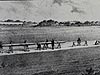 The Bache- Wurdemann Compensating Device
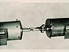 Eimbeck Duplex Bars
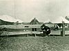 Iced Bar B 17
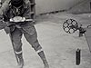 Steel Tape with Tape Stretcher
 Invar Tape
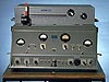 AGA Geodimeter NASM-2A
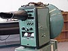 Tellurometer Model M/RA 1
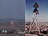 Laser Signal and Prismatic Mirror Reflecting System
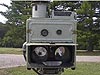 AGA Geodimeters, Models 4D and 4L
 Big Red
 AGA Geodimeter Model 6
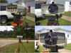 Hewlett-Packard Model 3800B Distance Meter
 Tellurometer Model MA-100
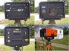 Ranger III and Rangemaster III
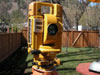 Topcon ET-1 Total Station
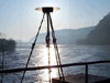 Trimble GPS Antenna
AGA Geodimeter NASM-2A
This photo shows a circa 1959 AGA Geodimeter NASM-2A. This instrument sent out a beam of light to a reflector and compared the wavelength of the outgoing signal to the wavelength of the returning signal, measuring the difference between the two (called the "phase shift"). Using multiple frequences of light, the instrument computed a distance based on the known lengths and measured phase shifts of returning light waves. In this way, the exact distance between measurement points was determined.
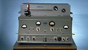
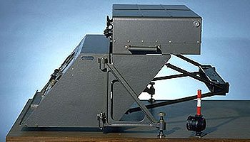
Top: A circa 1959 AGA 2A assembled and showing the front control pane. Bottom: The AGA 2A from the side showing the separate measuring and optical units. Photos courtesy of the University of New South Wales School of Surveying and Spatial Information Systems Virtual Surveying Instrument Collection.
First produced in Sweden in 1953, the Geodimeter was based on the principle that a beam of light could be used to measure the distance from one point to another. The Geodimeter could be used to measure base lines with greater precision than previously possible and accomplish in hours what had previously taken weeks. The instrument worked by sending a light signal of known wavelength to a reflector. The wavelength of the returning signal was compared to the outgoing one, and the difference (called the "phase shift") was measured. Using multiple frequences of light, the instrument computed a distance based on the known lengths and measured phase shifts of returning light waves. The Geodimeter was the first electronic distance measurement instrument to use visible light to measure distance.
The Coast and Geodetic Survey (C&GS) tested the various versions of Geodimeters rigorously as they became available. The Model 1, produced in 1953, was followed by Models 2 and 2A. Models 2 and 2A were similar to the Model 1, but had features that increased the Geodimeter's measuring range. The "2A" model, shown here, included a measuring unit containing electrical systems and an optical unit containing a light conductor and two large mirrors.
Historic Reference
People have always been fascinated with the starry sky, developing astronomy from myths into science. The evolution of telescopes and more detailed observation of planets and stars led to attempts to determine the speed of light as well as increasingly refined instruments to measure this speed.
It was in pursuit of the value of the speed of light that a Swedish physicist named Erik Bergstrand began experimenting with a system that bounced known, carefully modulated wavelengths of light off of a reflector at a precisely measured distance. Since the time between the outgoing and return of the signal was so infinitesimally short that it could not be measured directly, a special instrument called an oscilloscope was used to measure light travel time.
Having used distances to determine the speed of light to his satisfaction, Bergstrand then proposed to reverse the process. In the late 1940s, he asked the company Svenska Aktiebolaget Gasaccumulator (AGA) to develop the first commercial geodetic distance meter, and thus development of the Geodimeter began.
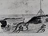
The skeleton towers built in order to see over obstructions during a survey had evolved over the years from wood to a standard steel Bilby tower, named after its designer, Jasper Bilby. During observations, equipment plus crew perched on a small platform on top of the tower, sometimes over 100 feet high. Monroe Rivers, Geodetic Advisor for Kansas and veteran of CG&S Geodimeter surveys, said that when using the 2A, "not much room [was] left on [the] Bilby Tower for observer and recorder."
In 1960, the Air Force asked the C&GS to determine the positions of missile tracking cameras around Cape Canaveral, Florida, with extremely high accuracy. A 2A was used to obtain results that far surpassed both the requirements and any accuracy ever obtained in an extensive geodetic network. The camera surveys were extended to other camera stations in Florida and Georgia, and then evolved into the Transcontinental Traverse, a continent-spanning, high-precision network of surveys that was completed in 1976.
- Distance Measurement Instrument Shown: AGA Geodimeter NASM-2A
- Location: Collection of the University of New South Wales School of Surveying and Spatial Information Systems, Scotland
- Manufacture Date: 1950s
- Dates of Use: 1950s - 1960s
- Photo Date: 2000?
Works Consulted
Cheves, M. (1999). Geodimeter-The First Name in EDM. [Electronic version]. Professional Surveyor, Vol. 19, No. 6.
Smithsonian Virtual Surveying Instrument Collection. (2006). EDM (Geodimeter Model 2A). Retrieved June, 2006, from: http://americanhistory.si.edu/collections/surveying/object.cfm?recordnumber=748815.
UNSW Virtual Surveying Instrument Collection (2000). Medium Range Distance Meter. Retrieved June, 2006, from: http://www.gmat.unsw.edu.au/currentstudents/ug/projects/f_pall/html/e11.html.
Related Web Sites