GPS: Nouvelle Survey
NOAA's National Geodetic Survey defines and maintains the National Spatial Reference System. Initially, this task was accomplished by line-of-sight surveys to measure longitude and latitude of survey marks. Since the introduction of the Global Positioning System, horizontal positioning is done faster, cheaper, and more accurately with greater flexibility and accessibility to remote areas.
High above the Earth, a constellation of satellites orbits our planet, transmitting radio signals that allow us to determine where we are on the Earth's surface. This Global Positioning System (GPS), when used according to specified procedures, can determine positional coordinates to centimeter-level accuracy anywhere on the surface of the Earth.
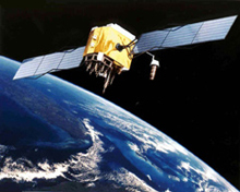
Global Positioning System satellite used for precise positioning and navigation.
GPS has revolutionized surveying, providing latitude, longitude, and height information more quickly, inexpensively, and accurately than was possible by traditional surveying methods. Integrating GPS data into the National Spatial Reference System (NSRS) is enhancing the reliability of transportation and communication systems, boundary and property surveys, land record systems, mapping and charting, and many scientific and engineering applications.
This article compares the techniques of traditional surveying with surveying using GPS and looks at how GPS has transformed the way that the National Geodetic Survey (NGS) maintains the NSRS.
Traditional Surveying
There are three types of "traditional" surveys: triangulation, traverse, and leveling. Prior to the advent of GPS surveying in the early 1980s, these surveys provided the basis for information contained within the NSRS.
Triangulation Surveys
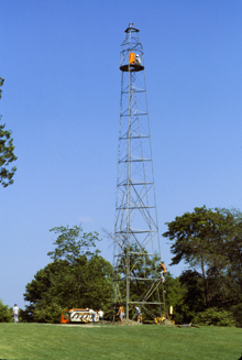
Used for surveying by the Coast and Geodetic Survey (and later by NGS) for almost 60 years, the Bilby Tower raised surveying equipment to a sufficient height to clear obstructions and provide the necessary clear line-of-sight between adjacent survey marks. Click image for larger view.
A triangulation survey determines the position of a point by measuring vertical and horizontal angles to control points using an instrument called a theodolite. Because this method required clear lines-of-sight, control points were generally placed at the greatest available elevations. In flat or obstructed areas, large towers, often 100-feet or more tall, were sometimes constructed to help assure line-of-sight. Also, distances were measured at intervals to provide scale to the survey. It often took days to acquire the observations and longer to process them.
Traverse Surveys
A traverse survey determines the position of a point relative to an out-of-sight control point by creating a cumulative series of distance and angular measurements from the control point to the point to be positioned. Originally, distances were measured with chains, bars, or tapes. Electronic distance measurement instruments (EDMI) were introduced in the 1950s and used microwave, light, and laser ranging to determine distances. These instruments provide positions good to about four inches (10 centimeters) to a normal range of about 30 miles (50 kilometers).
A clear line-of-sight is still required in traverse surveying, meaning that a high number of measurements are needed to complete a survey. Thus, the cost and complexity of the survey is often very large, and errors accumulate as more distances and angle measurements are necessary to connect to the new control point.
Leveling Surveys
A leveling survey determines the heights of locations above or below a model of the Earth known as the "geoid." There are three different types of leveling surveys: differential, trigonometric, and barometric.
The most accurate method of leveling is differential leveling. In this method, the height of one location is measured relative to the known height of another location. Readings are made on graduated rods held in an upright position ahead of and behind a carefully leveled instrument. The difference between the readings is the difference in elevation between the points.
Trigonometric leveling involves measuring a vertical angle from a known distance with a theodolite and computing the elevation for the point using trigonometry. This method permits the surveyor to do both triangulation and leveling at the same time, which is efficient, but less accurate, than differential leveling.
Barometric leveling involves measuring the differences in atmospheric pressure between points in the survey. While barometric leveling is the least accurate of the leveling techniques, it does rapidly provide relative heights.
Differential and trigonometric leveling require clear lines-of-sight, thus increasing the number of measurements needed and the cost and complexity of the survey.
GPS Surveying
Since 1983, GPS has revolutionized surveying. GPS offers an alternative to traditional surveying and can eliminate several of the limitations imposed by traditional surveys. Using GPS, it is now possible to perform surveys much more easily over long ranges and in areas where clear lines-of-sight between points are not available.
The use of GPS does have limitations. In environments where the view of the sky is limited, such as urban areas, the traditional survey techniques must still be used. This is because while GPS surveying does not require a line-of-sight between points within a survey, it does require unobstructed lines-of-sight to at least four satellites.
GPS observing sessions of only a few hours can yield three-dimensional positions with accuracies of a few centimeters. GPS antennae can be set up on tripods and connected to separate receivers, or antennae and receivers can even be carried in a backpack arrangement.
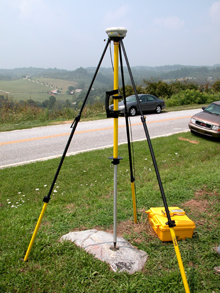
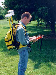
A GPS antenna mounted on a tripod over a geodetic mark (left); this setup is very portable. A backpack mounted GPS antenna and receiver (right); this is an extremely portable arrangement.
NGS actively supports GPS post-mission static positioning, post-mission kinematic positioning (aircraft, boat, or land vehicle), crustal motion, meteorology, and space weather and sea level studies. Static positioning refers to missions in which the GPS receivers are stationary during data collection. Kinematic missions are those in which the receivers are moving while collecting data.
The CORS Network
NGS helps surveyors who use GPS achieve more accurate results by operating the Continuously Operating Reference Station (CORS) network. The network is composed of over 1,000 permanently installed, survey-grade GPS receivers at sites in the United States, its territories, Canada, Mexico, Central and South America, and Iraq.
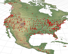
The Continuously Operating Reference Stations system is a network that continually collects GPS signals and provides these data to GPS users via the Internet for precise positioning activities. Click image for larger view.
CORS is a cooperative effort involving 175 organizations who own and maintain all but a few of these receivers. NGS collects the data from all of these GPS receivers and makes the data available to GPS surveyors so that they can correct for some of the errors that are in the GPS signals. In addition, the CORS network provides GPS surveyors with a direct link to the NSRS. By using data from CORS sites, people can get positioning accuracies at the centimeter level.
One way for surveyors to make use of the CORS network is through NGS's On-line Positioning User Service, also known as "OPUS." OPUS is an on-line software package that provides GPS users with an easy way to determine positions with respect to the CORS network. Through OPUS, users can submit their GPS data files to NGS for processing and receive (via email) a very accurate position computed for each data file with respect to the positions of three CORS sites.
Error Reduction
One of the other sources of error for GPS surveying is inexact knowledge of the locations of the satellites as they orbit the Earth. To help minimize this error, NGS computes improved GPS satellite orbits that tell us where a satellite is to within two to three centimeters at any given time. The orbital data are distributed as a "rapid" product which is available within 17 hours. A more accurate "final" product is available about 13 days after data collection. Other products which stem from these calculations are improved Earth orientation parameters, which give the position of the Earth's spin axis with respect to its crust and the length of the day.
The exact point on a GPS antenna where the position is calculated is called the "phase center." Knowing where this center is makes a big difference when you are trying to calculate positions at the centimeter level. The location of the phase center can change with the direction of the satellite by up to several centimeters. NGS calibrates this change for many different GPS antennae to achieve high levels of accuracy for GPS surveying (about two centimeters horizontally and vertically).
Conclusion
The evolution of surveying from chains, bars, tapes, theodolites, and levels through the EDMI of the 1950s to the GPS antennae and receivers of today has produced a dramatic increase in the speed and accuracy with which positioning can be accomplished. At the same time, the cost and complexity of surveying has decreased. NGS is working to enable the positioning community to use the latest technology to its fullest extent.
Contributed by Jim Rohde, NOAA's National Ocean Service
