Height Modernization—Leveling the Nation
Height Modernization is a program within NOAA's National Geodetic Survey that provides accurate height information by integrating Global Positioning System (GPS) technology with existing survey techniques. For years, GPS has been used to determine accurate positions (latitude and longitude). Now, by following Height Modernization standards, specifications, and techniques, GPS can efficiently establish accurate elevations for a wide variety of positioning and navigational needs.

Spirit leveling in front of "El Morro" in San Juan, Puerto Rico. Click image for larger view.
Like most people, scientists and engineers are constantly looking for faster and more accurate ways of doing things. Enter the use of the Global Positioning System (GPS) for surveying in the late 1980s.
While GPS has revolutionized surveying, the vertical accuracy of GPS measurements (elevations) has not been as good as the horizontal accuracy (latitude and longitude). Knowledge of elevations is critical to surveyors, engineers, coastal managers, developers, and those who make resource or land-use management decisions.
Because forces such as sea level rise, subsidence (i.e., land sinking), and geological events constantly change the surface of the Earth, it is necessary to periodically resurvey areas to correct for changes. State and local governments spend tens of millions of dollars each year adjusting engineering projects that are continually affected by changing land surfaces, so a fast, yet accurate, method for determining elevations is needed. Height Modernization, which uses GPS in conjunction with other new and existing technologies to increase the accuracy of elevation measurements, is one such method.
This article looks at the evolution of the Height Modernization (HtMod) Program within NOAA's National Geodetic Survey (NGS) and how the program is contributing to a state-of-the-art National Spatial Reference System.
Spirit Leveling: A Traditional Technique
Prior to GPS, the primary procedure for determining elevations involved instruments called "levels." The level, which is essentially a combination of a telescope and a spirit vial, is used to read values from a set of specially constructed and marked rods that look like long yardsticks. Leveling involves determining differences in elevation between survey points following a "leap frog" approach. Building off of known elevations and carrying elevations forward from point to point with a level and rods, surveyors construct a "level line."
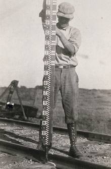
Traditional leveling involved using a level to read numbers marked on a rod, such as the one shown here. Click image for larger view.
Along the way, survey crews occasionally set a "benchmark" in the ground, as a reference point for future elevation surveys. NGS has established hundreds of thousands of these benchmarks across the United States. These marks make up a fundamental part of the National Spatial Reference System (NSRS), which is a consistent national reference framework that specifies latitude, longitude, height (elevation), scale, gravity, and orientation throughout the United States.
While leveling results in extremely accurate elevation measurements, it is a slow process that involves a lot of time and a lot of walking. Surveying an area using traditional leveling techniques is quite expensive, meaning that prospects for resurveying an area using these techniques are low, even if changes in the land surface deem resurveying necessary.
Height Modernization: Meeting a Need
Elevation data are a critical component of the NSRS. Data provided by the NSRS is used in the design, construction, and safe operation of roads and buildings; the transportation of goods and people by car, ship, or plane; and the monitoring and protection of our environment. Although accurate horizontal positions are available for much of the NSRS, vertical information in the NSRS is sometimes not as accurate due to oil and water extraction, tectonic plate movement (gradual movement of the Earth’s crust), earthquakes, erosion, etc. In addition, many vertical survey marks have been destroyed over time by cultural development and by natural forces.
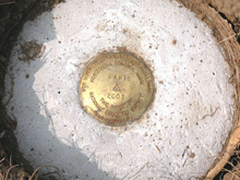
A National Geodetic Survey brass disk set in concrete. Click image for larger view.
Given the need to upgrade the vertical component of the NSRS, but considering the large amounts of time and money associated with traditional leveling techniques, in 1994, NGS began looking at using GPS, together with traditional leveling, gravity, and other technologies such as remote sensing to determine elevations. This process, now known as HtMod, uses special survey procedures that allow users to increase the accuracy of the vertical component of GPS measurements and achieve accurate heights.
HtMod Implementation
HtMod is designed to work all across the country. The process of height modernization, while faster than leveling, still takes planning and funding. Individual states must decide of their own accord to push the process forward. Since the late 1990s, the HtMod Program has been gradually gaining momentum.
Initial State Progress
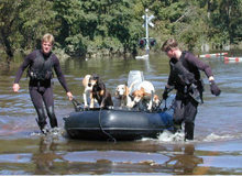
These animals were rescued in North Carolina after Hurricane Floyd. The HtMod Program is helping North Carolina maintain updated flood risk information. Image courtesy of the Federal Emergency Management Agency.
California and North Carolina were the first states to proceed with the HtMod update. Both of these states were in dire need of the new technology.
California has tectonic plates shifting and frequent earthquakes that affect benchmark accuracy. The state now has the California Spatial Reference Center, which helps manage surveys to monitor changes in coordinates as well as to update and supplement the vertical reference frame.
North Carolina needs height modernization to determine flood patterns and monitor the effects of subsidence. In 2000, North Carolina emerged as the first Federal Emergency Management Agency Cooperating Technical State. This title includes the responsibility to rigorously update Flood Insurance Rate Maps (FIRM) and to monitor changes in elevation and flood plain levels. HtMod is one tool helping the state meet these goals.
Congressional Direction
At the direction of the U.S. Congress, NGS conducted a Height Modernization Study in 1998. The purpose of the study was to determine the effectiveness of HtMod in California and North Carolina and its potential benefits to the nation. Prior to this study, there were indications that the use of GPS could substantially increase the speed of height surveys while decreasing overall costs, but no formal evaluation of the technique had been completed. The NGS study projected the use of GPS could result in cost savings of up to 90 percent over conventional surveying techniques.
Since 1998, Congress has appropriated over $38 million to the HtMod Program. The majority of this funding has supported specific state endeavors aimed at improving the accuracy of their vertical networks.
Implementation Today
Since the time when California and North Carolina started their programs, additional states have been stepping up and beginning the process of updating their elevations using HtMod. Today, California, North Carolina, Louisiana, Mississippi, Wisconsin, Alabama, Washington, Kentucky, Texas, Arizona, and South Carolina are all working toward improving the safety of their residents and the qualities of their lives through the HtMod Program.
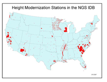
This map shows the locations of HtMod stations published and available in the NGS database as of March 1, 2007. Click image for larger view.
Implementation of HtMod is an evolving process. The HtMod techniques are not yet widely practiced by the surveying community. A major effort known as "technology transfer" is being undertaken to introduce these techniques and foster their widespread use. In addition, the existing geodetic reference framework that supports height measurements is outdated in many locations and must be modernized. NGS is meeting this challenge by enhancing the existing framework with a smaller network designed to support and utilize the technological advances of GPS. It is part of NGS’s continuing mission to make the substantial benefits of Height Modernization available to the nation and the world.
NGS HtMod Guidelines
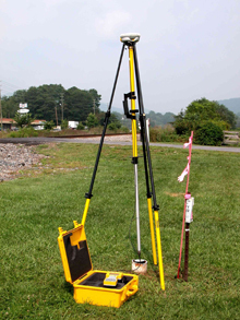
A GPS antenna on a tripod centered over a survey mark in North Carolina. Click image for larger view.
NGS, in cooperation with the GPS community, only recently developed standards, specifications, and techniques to enable GPS to attain the accuracy levels required for most applications using height information. These guidelines, which are available on the NGS Web site, provide detailed instructions for the amount of survey control required as a base from which to start the modernization of elevation data. NGS also provides instructions on how surveys must be carried out to ensure that results meet the requirements. Meeting these specifications is important to ensure that HtMod surveys can be tied to the NSRS.
A requirement of the NGS guidelines is that known horizontal and vertical survey control points must encircle the project area at certain maximum distances. Then, a survey network is planned with many interconnections, to tie old and new points together. High-quality GPS receivers, antennas, and tripods must be used and strict data collection and data processing procedures followed. This methodology replaces the old method of using spirit leveling alone to determine differences in elevation.
Conclusion

This photograph shows a neighborhood flooded after Hurricane Katrina. The HtMod Program could help in planning for and mitigating damages from floods.
There is an immense difference between how elevations are measured now versus how they were measured prior to the availability of GPS. The slow, labor-intensive spirit leveling of the past has been largely replaced by rapid GPS observations. There are only a few applications which will still require the advanced level of accuracy currently only achieved by leveling.
The HtMod Program will affect people’s lives in numerous, positive ways. Roads, bridges, and buildings can be built more efficiently; flood action plans can be rewritten and updated regularly; and earthquakes and tectonic plate movement can be monitored more effectively. Height Modernization will not only save lives, it will also save money. This program will give states every possible advantage to be better prepared for any natural disasters, changes, or problems that could arise. The benefits of HtMod far outweigh the initial cost and work needed to move the process forward.
Contributed by Aria Remondi and George Leigh, NOAA’s National Ocean Service
