Entering the Space Age: The Evolution of Satellite Geodesy at the Coast and Geodetic Survey
Geodesy is the field of science that is involved in the measurement of the size and shape of the Earth. Satellite geodesy is, quite simply, using satellite techniques to take these measurements. NOAA's National Geodetic Survey entered the field of satellite geodesy in the 1960s and since that time, satellites have played a key role in the development and maintenance of a national geodetic data system that is used for navigation, communication systems, and mapping and charting.
Today, many of us own hand-held global positioning system (GPS) devices or have cars that tell us where to go by using advanced positioning technology. While accurately knowing our position on the Earth’s surface is certainly a personal bonus, it is essential to building roads and bridges; ensuring safe and efficient transportation; or laying out infrastructure such as utility, energy, or communication systems. The science behind this positioning is called geodesy.

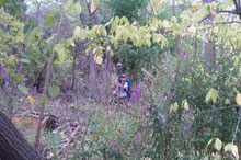
The use of GPS has revolutionized surveying. Click image for larger view.
Geodesy is the science of measuring and monitoring the size and shape of the Earth and the location of points on its surface. For nearly 200 years, NOAA’s National Geodetic Survey (NGS) has been in the business of developing and maintaining a national geodetic data system used for navigation, charting, and mapping. Manual instruments such as theodolites and distance measurement tools were the basis for determining vertical and horizontal positions for much of NGS’s history, that is, until the agency entered the space age…
This article looks at the historical evolution of satellite geodesy within NGS.
Getting Off the Ground
For the first 150 years of its history, the U.S. Coast and Geodetic Survey (the predecessor organization to NGS) carried out geodetic surveys only within the United States. During this time, most international cooperation involved the sharing of research results and the connection of the geodetic networks of the United States and Canada. Most employees of the agency were involved with acquiring and processing surveys and providing accurate coordinates to surveyors and cartographers within the U.S.
This changed quite quickly with the advent of the space age. Just days after the launch of Sputnik on October 4, 1957, scientists of The Johns Hopkins University Applied Physics Laboratory were able to determine Sputnik's orbit by analyzing the Doppler shift of its radio signals. Researchers soon realized that if a satellite's position was known and predictable, the Doppler shift could be used to locate a receiver on Earth.
The U.S. Navy developed this principle into the TRANSIT, a system of satellites and supporting ground activities that was intended primarily for the navigation of ships at sea. It was soon realized that this same concept could also be exploited for accurate geodetic positioning of stationary control points (fixed points on the Earth’s surface that are used for reference to other points).

Echo I was a balloon made of aluminum-coated Mylar that was launched by a rocket into space. When it reached orbit 1,000 miles (1,609 kilometers) above the Earth, it inflated from inside a 26.5-inch (67.3-centimeter) magnesium sphere to 100 feet (30.48 meters) in diameter.
The first U.S. balloon satellite, Echo I, was launched May 13, 1960. Scientists at the U.S. Army Aberdeen Proving Grounds quickly realized that the satellite could be photographed against a background of stars using cameras previously used for determining ballistic trajectories. Furthermore, photographs taken simultaneously at different locations could be used to determine the relative positions of those locations. This was the first use of artificial satellites for geodetic positioning. It offered an opportunity to determine the positions of survey stations separated by hundreds or thousands of miles.
C&GS Enters the Scene

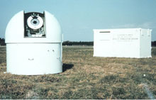
The BC-4 camera inside its observing dome. The dome was open only while observations were being acquired. The instrumentation shelter, containing timing, communications, and other electronic equipment, is shown in the background. The equipment was transported on a trailer and set in place with a crane. Click image for larger view and full caption.
The Coast and Geodetic Survey (C&GS) soon established an operational program to exploit the use of satellites to determine position on the Earth’s surface—a method known as “geometric satellite triangulation.” Operations began in August of 1963 with three observing stations that used photographs of the Echo I satellite against a background of stars taken with a Ballistic Camera-4 (BC-4).
This initial experiment of taking observations at three stations led to plans to establish a network of survey stations covering all of North America—the North American Satellite Triangulation Program.
The PAGEOS Satellite

The PAGEOS balloon satellite, built for the C&GS Worldwide Geometric Satellite Program, was a 30-meter-diameter sphere made from 0.0125-millimeter-thick Mylar externally coated with vapor-deposited aluminum. Click image for larger view and full caption.
While observations of the Echo I satellite were underway, it became apparent that with a higher satellite, it would be possible to establish relative positions of survey stations even further apart, even those on different continents. To support this concept, C&GS arranged with the National Aeronautics and Space Administration (NASA) for the design, constructions, and launch of the Passive Geodetic Satellite (PAGEOS).
With the launch of PAGEOS in 1966, C&GS set aside the North American program in favor of a worldwide program which became known as the Worldwide Geometric Satellite Triangulation Program.

The Worldwide Geometric Satellite Triangulation Program was based on the PAGEOS satellite. PAGEOS was placed in a higher orbit than the Echo satellites, allowing the establishment of even longer baselines. Click image for larger view and full caption.
Under this program, new BC-4 cameras were purchased and many new employees were hired to staff the observing stations and to handle the logistics of moving people and equipment to other countries. Also, the C&GS Photogrammetry Division was greatly expanded to take on the new task of measuring the photographic plates that showed the position of PAGEOS in the sky. These photos could be used to determine accurate locations of observing stations where the photos were taken.
The High Precision Transcontinental Traverse
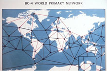
Like classical triangulation, satellite triangulation determines only the shape of the network of points; the distances between points must be provided by other information. If the distance between one pair of points was measured, then all the distances could be computed. Fortunately, the C&GS had already embarked on a program of high-precision traverses using laser-based distance measuring equipment. This program, called the “High Precision Transcontinental Traverse,” was extended to cover the entire U.S. The Transcontinental Traverse provided the length of the baseline connecting Moses Lake, Washington, and Beltsville Maryland, the two BC-4 stations in the U.S.
Other projects were undertaken in other parts of the world to establish and adjust high-precision traverses which could be used to provide the scale for the worldwide network. Some baselines, such as the line from Tromso, Norway, to Hohenpeissenberg, Germany, passed through several countries, and international cooperation was necessary to obtain the required information.
The End of the BC-4 Era
The worldwide BC-4 program came to an end in 1972. While the information it provided was one of the foundation datasets used in the Department of Defense World Geodetic System of 1972 (WGS-72), it became apparent that other satellite tracking technologies could provide geodetic position information faster and at lower costs.

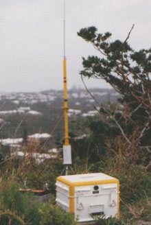
The Magnavox MX-1502 Geoceiver, 1979. All the components of this Doppler satellite tracking system are hand portable and can be taken on an airplane as excess baggage. The system uses all solid state electronics, and so is much less fragile than earlier systems.
Chief among these faster and less expensive technologies was the principle of tracking the Doppler shift of radio signals transmitted by a satellite, as had been pioneered by the Johns Hopkins University Applied Physics Laboratory. By 1972, Doppler tracking had become a mature technology. In operation, it was “all-weather,” meaning that, unlike using cameras that required a clear view of the sky, Doppler tracking could be used even when cloud cover was present. Furthermore, Doppler tracking used navigation satellites that already existed, thus avoiding a major cost element.
Like the BC-4 observing system, early Doppler observing systems required a trailer for transportation and a crane to put them in place. But, in 1971, the first miniaturized Doppler receiver was delivered, prices dropped, and it became feasible to perform surveys in many more isolated locations.
C&GS resisted the use of Doppler receivers for several years. There was an attempt to hold on to the BC-4 system by returning to the North American network project (now called the North American Densification Network). However, by 1974, this position was no longer tenable; the agency closed up the BC-4 project completely and bought a number of portable Doppler receivers.
Moving Forward: GPS
Over the next 10 years, NGS carried out a program of satellite Doppler surveys within the United States. By 1984, 242 of these positions had been established and positions had been computed in a coordinate system thought to be geocentric, meaning that its origin is at the center of mass of the Earth. Such systems are necessary for the computation of satellite orbits. These positions (as well as Doppler satellite positions in Greenland, Canada, and Mexico) were used as control in the adjustment of the North American Datum of 1983.
Although the satellite Doppler program was a great step beyond the BC-4 program, it too eventually came to an end. By 1984, the first launches of GPS satellites had occurred and it became clear that Doppler tracking had to yield to GPS tracking. NGS moved quickly into this technology, investing in some early tracking equipment and performing valuable early research. GPS continues as the sole surviving operational method of geodetic satellite surveying to this day.
The Coast and Geodetic Survey played an early and significant role in the development of the new field of satellite geodesy. Not only did the organization perform significant research, but it also completed a worldwide observational program. The optical BC-4 program eventually gave way to Doppler and GPS methods, based on the tracking of radio signals. Today, optical methods have been set aside and NOAA is a major developer of geodetic applications of GPS.
When used according to standardized procedures, GPS receivers can determine positional coordinates to centimeter-level accuracy anywhere on the surface of the Earth. GPS is a foundational component of the National Spatial Reference System (NSRS), which is maintained by NGS. The NSRS provides information essential for ensuring the reliability of transportation and communication systems, boundary and property surveys, mapping and charting, and many more scientific and engineering applications.
