Arts and Crafts: A Photo Collection Relating Past and Present at the National Geodetic Survey
This collection of six composite images explains the source and significance of some of the historic sketches found in the NOAA Library's rare book collection and relates them to the history and present work of an agency that began in 1807 as the Survey of the Coast and continues today within NOAA as the National Geodetic Survey. By comparing the past and present side-by-side, the collection illustrates how significantly technology has evolved over time.
The science of surveying is at least as old as the ancient Egyptians, who found it necessary to keep track of property boundary changes caused by cyclical flooding of the Nile River. A magnificent record has been left to us in the brightly painted imagery found in the tombs of the nobles responsible for these surveys. At least one memorial tablet left by an ancient Roman surveyor shows the component parts of a basic surveying tool of the time – the groma. As one would expect, the advent of books and the printing press have left us an even more complete record of surveying instruments and techniques used over the centuries. As times have changed, surveying instruments and techniques—and the means for recording these techniques and collected data—have also changed.
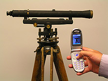
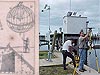
Coast Survey crews once communicated by means of Morse Code instead of the now ubiquitous camera-equipped cell phone. The Dietzen level shown in the photo is located at NGS headquarters in Silver Spring, Maryland. Click image for larger view and credit.
Believe it or not, there was once a time when cameras did not exist and information could not be provided digitally. Geographic information systems did not create eye-catching maps on computers and there was no National Geodetic Survey (NGS) Web site with a "Publications Available On Line" link. But even without these high-tech methods for record-keeping, we do still have a record of "the good old days."
In the world of science, information was once relayed via words and sketches crafted by hand and on paper—not an 8 x 10 glossy photo or pixels on a computer screen.
For several years, NGS has had copies of antique drawings of various survey-related instruments and scenes hanging throughout its office in Silver Spring, Maryland. This year's celebration of the 200th anniversary of the founding of the Coast Survey has led to a new awareness of NGS's heritage and to a curiosity about the images that, while technically scientific in nature, also serve as decorative works of art.About this Collection
They say a picture is worth a thousand words…this collection of images compares the surveying tools and techniques of days gone by to those used in much more recent times, spinning two marvelous tales. One tale explores the changing methods for recording information—from intricate, hand-drawn sketches in a surveyor's notebook to pixel-driven photographs captured on a digital camera and posted on a Web site. The second story lies not in how the image was produced, but rather in the information depicted in the image. This is a tale of how the craft of surveying—an art to which NGS has been dedicated for 200 years—has evolved.
This collection of six composite images explains the source and significance of some of the historic sketches held by NGS and relates them to the history and present work of an agency that began in 1807 as the Survey of the Coast and continues today within NOAA as the National Geodetic Survey. By comparing, side-by-side, the past and the present, the collection illustrates how significantly technology has evolved over time. One thing, however, that has not changed is the organization's commitment to high standards and accuracy. The tools, hairstyles, and clothing styles may have changed, but the value, importance, and integrity of the collected information has never wavered.
You can browse through the images in the collection by clicking on the links to the right or click here to view the items in the Arts and Crafts Photo Collection.A Brief History of Keeping Track
Those who remember their high school geometry course will find the core of geodetic surveying familiar: given a certain amount of information about the angles and lengths of the sides of a triangle, it is possible to calculate the remaining unknown lengths and angles of the triangle. Given that information and a beginning point whose coordinates are already known ("X,Y" on the high school pop quiz and "latitude and longitude" at NGS), it is possible to build a framework to determine the location of new points by the measurement of new angles and distances.
Classical (pre-global positioning) geodetic surveyors measured angles and distances with highly accurate equipment and techniques and performed calculations based on the reality that the measurements were performed on the curved surface of the Earth. In classical surveying, a line of sight is necessary between stations since it is necessary to carefully sight on, or align with, a target during measurements. Until the 1950s, it was also necessary to measure the distances on a line, called a "base line," which had been carefully cleared, graded, and leveled. The distances were then measured by carefully moving metal bars or tapes, usually 15 to 150 feet in length, end-to-end along the complete distance of the base line. Precise measurements of base lines that were typically 6 to 12 miles in length would often take several weeks to complete.
Works Consulted
Knops Boekrestauratie. (1998). Time-table (Chronological). Retrieved September 2006, from http://www.xs4all.nl/~knops/timetab.html.
The Metropolitan Museum of Art. Chauvet Cave, ca. 30,000 B.C. Retrieved
September 2006, from
http://www.metmuseum.org/toah/hd/chav/hd_chav.htm.
University of California, San Diego, Department of Communication. (2000).
Manuscripts, Books, and Maps: The Printing Press and a Changing World. Retrieved
September 2006, from
http://communication.ucsd.edu/bjones/Books/booktext.html.