Oceans, Coasts & Great Lakes Research: Modeling the Future
NOAA, in cooperation with its research partners, explores and investigates ocean and coastal habitats and resources. NOAA provides scientific results to help manage and understand fisheries, conserve and protect our coasts, and build a stronger economy through marine products and businesses.
- Introduction
- Ecological Forecasting: GLERL
- Environmental Change: AOML
- The Future of Fish: PMEL
- Conclusion
Imagine being able to glimpse into the future, to see the effects of pollution, natural disasters such as hurricanes, and human-induced disasters such as oil spills. Scientists can do just that, not using a crystal ball, but instead by using models.
Models are computer simulations that allow scientists to manipulate variables, such as wind speed in a hurricane, to determine how a scenario will pan out. Models that incorporate all aspects of the Earth environment are becoming increasingly important as scientists, environmental managers, economists, and average citizens want to predict how specific actions or events will affect the environment.

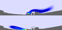
NOAA's Great Lakes Environmental Research Laboratory is currently developing models that will rely on recent and real-time physical, chemical, and biological data to predict location and movement of pathogen concentrations in the water and along beaches in nearshore regions. Click image for larger view and full caption.
Models are one tool that NOAA scientists will use to increase understanding of how ecosystems work. Understanding coastal ecosystems is a daunting but approachable challenge that will require scientists to have broad academic bases, be able to work with diverse international groups, and have access to expanded observing systems needed to monitor a greater amount of our ocean.
Over the next 20 years, the nation's population will increase and demand on resources will grow. This article considers how ocean and coastal research at some of NOAA's labs will help us respond to these changes, allowing us to understand and predict changes in the Earth's environment and to conserve and manage resources to meet our nation's economic, social, and environmental needs.
From an Ecosystem Focus to an Ecological Forecasting Capability: NOAA's Great Lakes Environmental Research Laboratory
NOAA's Great Lakes Environmental Research Laboratory (GLERL) is the only NOAA research laboratory that has a breadth of scientific expertise to fully address complex issues in the Great Lakes ecosystem. The laboratory predicts impacts of stresses placed on the ecosystem, to provide information needed to make adaptive management decisions. Understanding the future direction of the laboratory requires an understanding of its past.
The Roots of GLERL

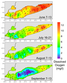
Seasonal changes in near-bottom dissolved oxygen concentrations collected during 2005 by the GLERL-led International Field Years on Lake Erie indicate severe depletion (hypoxia) of oxygen in Lake Erie's Central Basin. Note: do not cite or publish this figure or data depicted in it without the express permission of IFYLE scientists Stuart Ludsin or Tom Johengen. Click image for larger view and complete caption.
In the early 1970s, the health of the Great Lakes was on the decline, culminating with the declaration of Lake Erie as a "dead" lake. Rising concerns over the condition of the Great Lakes resulted in NOAA's International Field Year for the Great Lakes (IFYGL). The IFYGL was an effort by U.S. and Canadian scientists to apply an "ecosystem approach" to studying Lake Ontario. This broad approach involved looking at all aspects of the Great Lakes ecosystem, to understand declining water quality and habitat degradation.
Borne out of the activities of the IFYGL, NOAA's Great Lakes Environmental Research Laboratory was founded in 1974. GLERL carried on the ecosystem approach instituted by IFYGL. Emerging GLERL science relied heavily on the design and testing of mathematical, computer-based models and simulations. These models and simulations allowed GLERL researchers to better explain and understand the often subtle and complex interplay of physical, chemical, and biological factors affecting the ecosystem.
Over the years, some of these models and simulations were refined to allow forecasting of how elements such as ice cover, water quality, temperature, or water current movement might change over time. These efforts resulted in a model that covers all of the Great Lakes and, in 2005, the model was operationally turned over to the National Weather Service as the Great Lakes Coastal Forecasting System.
Future Directions

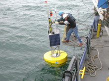
Early test buoy deployment during development of GLERL's Real-Time Environmental Coastal Observation Network (RECON). Observations collected from RECON buoys are incorporated into GLERL models. Click image for larger view.
As GLERL looks ahead, the laboratory will continue to build upon past successes. GLERL will produce a mix of forecasts for a suite of ecological conditions such as the presence and distribution of harmful algal blooms; distribution, size, and condition of fish species; and appearance and spread of new non-native species. Information from these forecasts will help coastal managers make decisions about issues such as water resources, water quality, human health, fish recruitment and productivity, and invasive species.
Models will allow managers to make decisions using an approach that is adaptive, geographically specific, and takes into account ecosystem knowledge and uncertainties. The focus on ecosystem forecasting ensures that GLERL science is working to protect, restore, and manage the use of coastal and ocean resources.
Scoping Environmental Change: NOAA's Atlantic Oceanographic and Meteorological Laboratory
Our coastal environments are continuously changing-shorelines erode, new beaches are created, organisms come and go. Some of these changes are the result of natural, on-going processes while others are caused by human activities. Understanding these changes and how best to manage change are areas of future focus for NOAA research.
NOAA's Atlantic Oceanographic and Meteorological Laboratory (AOML), in Miami, Florida, is already working to characterize environmental changes in Florida's coastal waters and the Gulf of Mexico. AOML is developing innovative monitoring techniques, including increasing the number of automated, in situ measurements that deliver real-time data directly to the laboratory. This type of data delivery reduces the need for scientists to spend days on ships collecting observations. Rather, scientists can be in the lab, analyzing information almost immediately after it is collected.

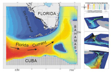
This image depicts a basic model grid/domain for the South Florida Hybrid Coordinate System Model that illustrates the movement of bottom water into the model. Click image for larger view.
Researchers are making observations now that can help in forecasting future changes. These observations range from physical measurements of the environment, such as temperature readings, to the growth of cities. These observations help us to understand how the coastal environment responds to stresses such as development, agriculture, and increased population density. Observations also allow scientists to create a present-day image, or baseline, for forecasting future impacts. Using this baseline as a starting point, scientists can predict environmental responses to specific changes. These efforts are all geared towards building a better understanding of the factors that affect environmental quality and how to manage these factors to balance human use and needs with ecological health and protection.
Many of AOML modeling efforts are already in use for a variety of applications. Models are allowing NOAA to evaluate the impact of management decisions, determine areas that should be protected to allow fish reproduction, or understand the downstream impacts of hurricanes on a local region. Often times, these models are produced with partners such as the Rosenstiel School of Marine and Atmospheric Sciences at the University of Miami, Florida State University, and the Naval Research Laboratory.
The Future of Fish: The Pacific Marine Environmental Laboratory
Many of us enjoy fresh seafood. Ensuring that this seafood continues to be available in healthy abundances requires careful management. This management in turn requires tools for understanding how and why populations of fish change over time.
At NOAA's Pacific Marine Environmental Laboratory and Alaska Fisheries Science Center physical and biological scientists join together to use modeling to forecast how fish populations are likely to change over time. Thanks to years of study and data collection, researchers are able to make these predictions about a particular fish species. This forecasting is immensely valuable to scientists, economists, government agencies, and conservationists. Industry must prepare for changing abundance and distribution of commercial species to optimize economic return and maintain a sustainable resource. Managers must make meaningful and effective decisions based on assumptions of the future state of fishery resources.
As the human population continues to grow and global ecosystems are perturbed by effects of that growth, society is challenged to steward the exploitation of marine resources for the health of the planet. As result of the forecasting, fishery populations can be managed more efficiently and effectively because managers and policy makers have more information available to them to make better decisions.
One example of a program that has been successful in forecasting fish populations is the Ecosystems and Fisheries-Oceanography Coordinated Investigations (EcoFOCI). Through EcoFOCI, NOAA is developing indices of ecosystem status and designing forecast models to predict future states of the North Pacific Ocean's ecosystems and individual populations of living marine resources. These tools will allow decision makers to manage the marine resources so that they can be used in a sustainable way.
In present-day management, predicting the population of a single species of fish falls short of ecosystem management requirements. Fragmented, single-species approaches do not take into account the complexity of the many ecosystem interactions that produce population changes. For instance, an increase in the amount of food might lead to the conclusion that more pollock would survive to an age where they can be harvested. However, the increase in food may support other fish that are competitors of pollock or even consumers of pollock.
Interdisciplinary, multi-species approaches hold the most promise for improving understanding and forecasting of these complex systems. They consider the interconnectedness and, sometimes, delicate balance of marine life and can present information in forms that are immediately useful to resource managers. NOAA will continue to improve forecast models as more information becomes available through the observations of researchers. The increasing amounts of data help scientists refine their knowledge of how ecosystems work and provide a greater base of information for models, ultimately leading to smarter and more accurate environmental predictions.
Conclusion
Over the course of the next 20 years, we can only imagine how technology will increase the computing power available to NOAA or enhance the methods used to gather coastal and ocean observations. However, as NOAA glimpses into its own future, it is clear that models will play an integral role in researching our oceans, coasts, and Great Lakes. Information generated from these models will help us to protect and conserve our marine resources, while ensuring that we are able to enjoy and prosper from these resources.
Contributed by Erica Rule and Cassandra Lopez, NOAA's Office of Oceanic and Atmospheric Research
