Checking the Forecast for Coastal Environments
Ecological forecasts predict the impacts of chemical, biological, and physical changes on ecosystems, ecosystem components, and people. NOAA has initiated a suite of ecological forecasts to support more effective ecosystem management. Ecological forecasts bring together wide-ranging research and observation programs to allow coastal resource managers to answer the "what if" questions about factors that affect coastal resources.
- Introduction
- Short-term Ecological Forecasting
- Long-term Ecological Forecasting
- Conclusion
- Works Consulted
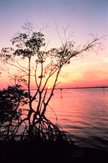
Ecological forecasts can help predict the effects of multiple types of stress on coastal areas, such as this mangrove ecosystem.
Every morning, many Americans wake up and consult their televisions, radios, newspapers, or the Internet for the weather forecast. Forecasts help them plan their activities for the day, and are one of the most recognizable products provided by NOAA. Imagine how useful it would be to predict the future state of coastal ecosystems, given the number of factors that can influence them. It would help people to plan and prepare for environmental changes and to manage coastal resources. NOAA now provides some coastal and ocean forecasts and has embraced a vision to provide more of them in the next 20 years.
America's ocean and coastal environments provide habitats for a range of estuarine and marine life and opportunities for business and recreation. These environments provide a broad range of services, both ecological and economic. Marine environments also play a significant role in supporting the economy through tourism, recreation, transportation, natural gas and oil deposits, fishing, and many other water-dependent functions. Many of these uses, however, can conflict or compete with one another. In addition, marine and coastal habitats are also threatened by pollution, climate change, storm damage, and increasing development pressures. Society needs to understand the impacts of human activities and natural processes and to forecast changes, so that plans can be made to address them.
Forecasts are a part of our everyday lives. Besides weather forecasts, climate forecasts help agricultural, energy, and other businesses make plans. Economic forecasts help individuals and businesses navigate the uncertainties of the financial world. Similarly, ecological forecasts allow people to answer the "what if" questions in coastal management.
Currently, management of oceans and coasts is often based on reacting to events as they occur, such as a severe storm or an oil spill. Ecological forecasts can and will allow managers to be more proactive in their decisions and planning.
NOAA has identified development of its ecological forecasting capabilities as one of its highest priorities. This article looks at some specific aspects of successful ecological forecasts and considers what else lies ahead for this initiative.
Local, Short-term Ecological Forecasting
Local, short-term ecological forecasts are like weather forecasts, with predictions of what is likely to happen at particular locations in the short term. NOAA has produced several examples of these types of forecasts, including those described below.
Sea Nettles in the Chesapeake Bay
Sea nettles, a type of jellyfish, seasonally infest the Chesapeake Bay and affect many activities. Vacationers frequently shun Chesapeake Bay beaches to avoid painful stings. Also, sea nettles are voracious predators, devouring copepods (tiny crustaceans), fish eggs, larvae, and comb jellies, thereby affecting the food web and possibly the abundance of fish in the bay.
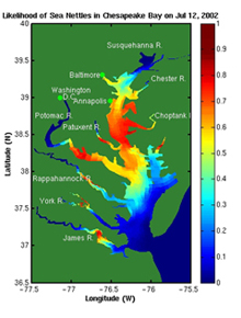
This image illustrates the chances of encountering sea nettles in the Chesapeake Bay. Parts of the map shown in red are those areas where the chance for a sea nettle encounter is greatest.
Knowing where and when to expect this nuisance may help people better plan their activities and reduce the problems they experience.
The environmental conditions, including salinity and temperature, associated with the presence of sea nettles in the Chesapeake Bay are relatively well established. NOAA's National Ocean Service, NOAA's National Environmental Satellite, Data, and Information Service, and other partners developed an experimental procedure which produces maps illustrating probable distribution patterns of sea nettles based on salinity and temperature models and NOAA satellite imagery.
NOAA and partners now produce forecasts of probable sea nettle presence every Friday, identifying locations where current environmental conditions are favorable to sea nettles. This framework is also being adapted to help predict harmful algal blooms (HABs) in the Chesapeake Bay.
Development and Movement of Harmful Algal Blooms

When an algal bloom severely depletes the oxygen in coastal waters, massive die-offs of fish species (known as "fish kills") can occur.
HABs, often called "red tides," occur in every coastal state and have caused a cumulative economic loss exceeding $1 billion over the last two decades. Movement of HABs from the ocean to shore can cause illness and death in humans, fish, and marine mammals. Florida red tides, for example, release neurotoxins that have killed fish and marine mammals and caused respiratory impairments for people along the shore.
NOAA's National Centers for Coastal Ocean Science, Center for Operational Oceanographic Products
and Services, Coastal Services Center, and the National Environmental Satellite, Data, and
Information Service work together to produce red tide forecasts in the Gulf of Mexico. The
forecasts are based on satellite imagery, data from research vessels, and models. Combining
this information allows NOAA to alert local, state, and federal officials of
the location and movement of blooms. The forecast system also provides public condition reports daily.
Improved understanding of how physical and biological processes interact to promote
bloom development enables scientists to develop reliable forecast models. Their
forecasts can then support rapid response by monitoring agencies and health departments
to safeguard public health, local economies, and fisheries.
Oil and Chemical Spill Modeling
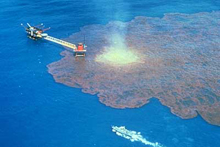
The IXTOC I exploratory well blew out on June 3, 1979, in the Bay of Campeche off Ciudad del Carmen, Mexico. An estimated 140 million gallons of oil spilled, which puts this spill as #2 on the all-time list of largest oil spills, eclipsed only by the deliberate release of oil during the 1991 Gulf War.
The NOAA Office of Response and Restoration's Emergency Response Division (ERD) responds to oil and chemical spills in coastal U.S. waters.
Using information about the amount and type of oil spilled, as well as information about winds and currents in the region of the spill, scientists forecast the movement and behavior of spilled oil or chemicals, evaluate the risks to resources, and recommend protection priorities and appropriate cleanup actions. The forecasts are a critical part of the nation's response to both minor and major spill events. The ERD team develops and uses a range of models that predict the movements of the spills, including potential for coming ashore and damage to sensitive environments.
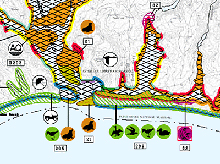
An Environmental Sensitivity Index map, showing part of the Point Reyes National Seashore. Click image for larger view and full caption.
By including ecological information such as the effects of oil and its breakdown products on aquatic vegetation and animal species in trajectory forecasts in the future, NOAA can provide better predictions of the effects of oil and chemical spills on surrounding habitats.
Long-term Ecological Forecasting
Some ecological forecasts focus on longer term or more broad issues (such as year-to-year variations in fish stocks). Several examples highlighting NOAA efforts to develop longer-term forecasts are described below.
Sea Grass Restoration Suitability and Recovery Rates
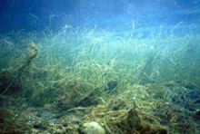
NOAA's National Centers for Coastal Ocean Science conduct research on sea grass habitat-assessing its health, defining its ecosystem function, and determining methods of restoration.
Sea grass beds are valuable ecosystems that provide refuge and food for wildlife, fish, shellfish, and the food webs that support them.
NOAA's National Centers for Coastal Ocean Science has developed forecast models that identify the best areas for sea grass restoration based on the probabilities that beds will not be lost in severe storms. Other models forecast rates of sea grass recovery so planners can set realistic restoration milestones. NOAA's work to identify suitable sites and to forecast recovery rates increases restoration project success. These methods also provide a basis for habitat damage assessments.
Eutrophication and Hypoxia Reduction
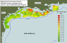
This map shows bottom dissolved oxygen contours in the Gulf of Mexico taken July 14-16, 2006. Click image for larger view.
The National Academy of Sciences recently concluded that nutrient pollution is the most serious coastal pollution problem. The most dramatic example of this impact is the area commonly called the "Dead Zone" in the northern Gulf of Mexico. This massive region of very low water oxygen levels (hypoxia) stretches from the Mississippi River to Texas coastal waters. In 2002, the zone covered an area larger than the state of Massachusetts. The Gulf contains almost half of the nation's coastal wetlands and supports approximately 20 percent of the dollar value of its commercial fishery landings.
Two sets of forecasts developed through the National Centers for Coastal Ocean Science have shown that reducing the current annual nitrogen load of 1.6 million metric tons from the Mississippi River system by 30 to 40 percent would dramatically reduce the hypoxic area and move toward the goal set in the Federal-State-Tribal Action Plan for reducing hypoxia in the Gulf. The forecasts are based on nitrate loads from the Mississippi and Atchafalaya rivers and incorporate the previous year's load to the system.
Conclusion
The ecological forecasts highlighted in this article help society and the economy. For example, a HAB forecast can reduce monitoring costs and may have public health benefits. However, forecasts may have undesirable results if they are imprecise, incorrect, or inappropriately distributed. Therefore, it is critical that any ecological forecast includes the uncertainty associated with it, so that managers can appropriately adjust their decisions.
NOAA's goal for the future is to build a collection of ecological forecasts which scientists and resource managers can use to conserve and manage our nation's coastal resources. This will require a better understanding of ecosystem processes, including the influences of the communities and economies that affect them. It will depend upon timely data from observations, such as could be provided by the Integrated Ocean Observation System, and timely and clear communication of forecasts. NOAA's vision is to use ecological forecasting to help sustain healthy and productive oceans for future generations.
Works Consulted
NOAA. (2002). Ecological forecasting: A new outlook for NOAA. Retrieved August, 2006, from http://www.magazine.noaa.gov/stories/mag65.htm.
NOAA. (2005). Research in NOAA: Toward Understanding and Predicting Earth's Environment. Retrieved August, 2006, from http://nrc.noaa.gov/Docs/research_cover.pdf.
