Hurricane Katrina
The Magnitude of Destruction
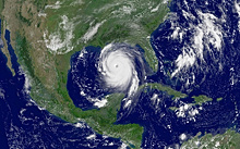
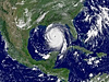
NOAA satellite image of Hurricane Katrina, taken on August 28, 2005, at 11:45 a.m. EDT, a day before the storm made landfall on the U.S. Gulf Coast. While in the Gulf of Mexico, Katrina’s winds peaked near 175 miles per hour. Click image for larger view.
On August 29, 2005, Hurricane Katrina devastated coastal areas of the Gulf Coast states of Alabama, Louisiana, and Mississippi, including the city of New Orleans. It was among the greatest of natural disasters to ever strike the United States. The vicious storm killed over 1,500 people, disrupted thousands of lives over tens of thousands of square miles, and damaged or destroyed 275,000 homes. Damage estimates exceeded $100,000,000,000. This unparalleled disaster brought together all of NOAA’s capabilities and assets on an unprecedented scale to save life and property prior to and during the hurricane and to help in response and recovery efforts in the storm’s aftermath.
The Forecast

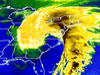
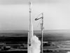
NOAA hurricane hunter aircraft made ten flights into and around the eye of Hurricane Katrina. Click image for larger view.
Over 1,100 NOAA staff members were directly involved with the federal government’s forecast and response to Katrina:
- Satellites from the National Environmental Satellite, Data, and Information Service tracked Katrina from its inception to its end.
- Hurricane hunter aircraft from the Office of Marine and Aviation Operations penetrated and flew above the storm to monitor both intensity and location and to improve forecast tracks.
- Models developed by the Geophysical Fluid Dynamics Laboratory predicted the final track and landfall within narrow limits.
- The National Weather Service forecast office personnel at Slidell, Louisiana, heroically stood by their post and issued an unprecedented, doomsday warning beseeching citizens to evacuate.
Disaster experts credit NOAA’s dire forecast and warning with saving untold lives. NOAA’s National Hurricane Center was extraordinary in helping prepare the citizens of the Gulf Coast for the onslaught of Katrina. The timeliness and accuracy of the forecasts warnings issued by the Center were well above average and contributed significantly to a near 80 percent evacuation rate of New Orleans, about double the usual rate. Lead times on hurricane watches and warnings for Louisiana, Mississippi, Alabama, and the Florida panhandle were eight hours above average.
The evacuation rate during Hurricane Katrina is an impressive public response to an approaching threat and is due in large part to the partnership between NOAA, the local emergency management community and the media. Despite the significant evacuation rates, the large loss of life reminded the nation of the importance to educate people at risk.
The Response
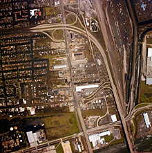
NOAA aerial image of Hurricane Katrina’s devastation in New Orleans. Note the roadway cut off by flood waters in upper left. Evacuated residents relied on these photos, posted on the Web after the storm, to determine if their homes were flooded. Click image for larger view.
Following Katrina’s passage, NOAA mobilized rapidly to evaluate the extent of damage, to direct resources to those most in need, and to help minimize further damage to the environment. NOAA’s responded immediately to the disaster by:
- Flying photogrammetric missions to document the nature and extent of coastal damage. The National Geodetic Survey took 8,300 images, covering almost 1,600 miles of mile-wide flight lines. These images appeared immediately on the Internet to help those most affected by the hurricane determine if their homes, businesses, and properties had been damaged or destroyed. Nearly five million photos were downloaded daily from NOAA Web sites in a one-week period.
- Deploying its largest contingent of navigation response teams in history to survey devastated Gulf Coast waterways. These survey teams from the Office of Coast Survey labored tirelessly to insure safe navigation channels and allow movement of response equipment and supplies as well as open up major ports to cargo operations.
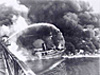
- Evaluating nearly 400 reported pollution releases, numerous sunken vessels, and an unknown number of unreported hazardous material releases. NOAA’s Office of Response and Restoration focused on 16 significant spills, which experts estimate released seven million gallons of oil in and around the Mississippi River Delta.
- Operating NOAA ships for navigation response teams and providing helicopter support for hazardous materials response teams to find and evaluate oil and chemical spills.
- Measuring contaminant concentrations in water, sediments, fish, and shellfish in marshes, estuaries, and offshore areas. The National Centers for Coastal Ocean Science sampled scores of sites for pesticides, herbicides, nutrients, metals, flame retardant chemicals, hydrocarbons, biphenyls, and human pathogens that may have been released to the environment during the storm.
- Assessing damage suffered to the region’s fisheries facilities.
- Staffing state agencies to assist the states’ plan for recovery.
- Removing debris and obstructions from watersways months after the storm in an ongoing effort to improve safety for navigation.
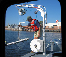
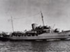
After Katrina, navigation response teams surveyed several miles of the Mississippi River, the Gulf Intracoastal Waterway near New Orleans, Port Fourchon, Biloxi, and Pensacola, and the area around Gulfport, Mississippi. Sonar equipment (shown here) helps identify submerged obstructions. Click image for larger view.
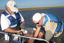
Marine scientists sampled scores of sites in the region, testing for pesticides, herbicides, nutrients, metals, flame retardant chemicals, hydrocarbons, biphenyls, and human pathogens. Click image for larger view.
This was all done under difficult circumstances as Katrina damaged or destroyed numerous NOAA facilities including National Marine Fisheries Service facilities, facilities at the Stennis Space Center, and National Weather Service forecast offices. NOAA personnel stationed in the area suffered along with their fellow citizens as their homes were also destroyed or damaged by the fury of Katrina.
Readiness for Future Disasters
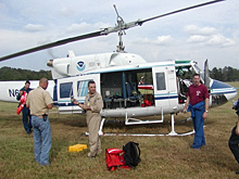
Over 1,100 NOAA staff were directly involved in the forecast and response to Hurricane Katrina. Helicopters were widely used to evaluate nearly 400 reported pollution releases attributed to the storm. Click image for larger view.
NOAA’s response to Hurricane Katrina clearly demonstrated its commitment to the safety and welfare of the people of the United States. The response highlighted its science capabilities in hurricane monitoring, prediction, and modeling, data acquisition, and contaminant sampling; its stewardship in assisting both economic and environmental recovery; and its service commitment to issue timely warnings for evacuation, to open ports after the storm, and to assist other government agencies and the people of the Gulf Coast through such activities as aerial photography to determine extent of damage and areas requiring immediate assistance.
NOAA was well prepared to forecast and respond to this, the nation’s greatest natural disaster. Its greatest test in the wake of Katrina was in the magnitude of the devastation and the sheer volume of work required to meet the needs of the citizens of Alabama, Louisiana, and Mississippi within the scope of NOAA’s responsibilities.
The NOAA response to Hurricane Katrina also demonstrated beyond a doubt the capabilities of all elements of NOAA acting in concert to serve our nation. The focused efforts of NOAA in response to this unprecedented disaster saved hundreds if not thousands of lives, helped disaster response teams marshal resources to those points most needed, and helped mitigate further environmental damage.