The Launch of TIROS I Weather Satellite
Early Dreams and Visions
For many years, weather prognosticators dreamed of observing weather systems from afar so they could view and predict storms moving over the surface of the earth. As early as 1939 George Mindling, a visionary and poetic Weather Bureau official, predicted:
Television is coming, it is not far away;
We'll be using that too in a not distant day.
Photographs will be made by the infra red light
That will show us the clouds both by day and by night.
From an altitude high in the clear stratosphere
Will come pictures of storms raging far if not near
Revealing in detail across many States
The conditions of weather affecting our fates....
In the coming perpetual visiontone show
We shall see the full action of storms as they go.
We shall watch them develop on far away seas,
And we'll plot out their courses with much greater ease.

The first image taken from TIROS I on April 1, 1960. When stations on Earth received data from TIROS, technicians recorded it on 35 millimeter film for making prints and large projections of the image. Forecasters dreams of watching weather from space had finally come true. Click image for larger view.
During the 1950s weather scientists gave serious thought to capturing images of meteorological phenomena from satellites launched into space by powerful rockets. Dr. Harry Wexler, chief scientist of the Weather Bureau during that period, strongly advocated meteorological satellites. In March 1958, the President's Science Advisory Committee stated "The satellite that will turn its attention downward holds great promise for meteorology and the eventual improvement of weather forecasting." Two months later, Project TIROS (Television and Infra-Red Observation Satellite) was born when the U.S. Committee on Meteorological Satellites began its initial planning sessions.
The First Meteorological Satellite

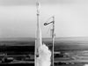
TIROS I, the world's first meteorological satellite blasts off aboard a Thor-Able rocket on April 1, 1960, from Cape Canaveral, Florida. The day marked the first time it was possible to observe the Earth's weather on a regular basis from space.
Not quite two years later, George Mindling's vision came true when NASA launched the world's first meteorological satellite, TIROS I, on April 1, 1960, aboard a aboard a Thor-Able rocket. This ushered in a new era of weather observations from space and an era when human beings could see their planet from above and better comprehend its beauty and fragility.
TIROS I demonstrated the ability to acquire images of the Earth's cloud cover over much of the planet. The spacecraft contained two compact television cameras (one wide angle and one narrow angle), two video recorders, a command and control electronics system, a communication system, solid rockets for spin control, power supply with rechargeable batteries, and a cylindrical solar array. It weighed 122kg (268 pounds), was 1.1 meter (43 inches) in diameter, and stood 0.6 (23 inches) meter high, not including antennas on the top and bottom of the spacecraft.

The TIROS I satellite. The blue panels show the solar sensors.
The satellite survived 1,302 orbits before it ceased operating in mid-June 1960 due to an electrical failure. It generated nearly 23,000 pictures of the Earth. During its 78-day lifespan TIROS I cameras captured a tropical storm, the cloud system of a large extra-tropical cyclone in the Gulf of Alaska, and pack ice conditions in the Gulf of St. Lawrence. Although the television technology and techniques for processing the images sent back to Earth were crude by today's standards, the launch of TIROS I not only led the way to new understandings in meteorology, but also broadened humanity's view of our Earth, its natural wonders, and its place in the universe.
Pioneering Success Leads to More Weather Satellites

This diagram shows the structure of the TIROS I. One wide-angle camera provided a view of about 750 miles straight down and a narrow angle camera provided a view of about 80 miles. The satellite could be commanded to take a picture every 10 or 30 seconds when it was within range of a ground station. A clock-controlled tape recorder could store up to 32 images when the satellite was out of range. Click image for larger view.
The success of TIROS I encouraged the Weather Bureau, along with colleagues in the military, NASA, and the private sector to begin developing and operating a global weather satellite observing system in 1961. They launched other polar-orbiting TIROS research satellites over the next several years to test new camera lenses and transmission techniques. TIROS VIII, launched in late 1963, successfully tested an automatic picture transmission system which continually relayed imagery to ground receiving stations anywhere in the world along the satellite's track.
The TIROS IX satellite, launched into sun-synchronous, near polar-orbit in 1965, gave the first complete daily coverage of the entire sun-illuminated portion of the earth. Launched just a few months earlier, the NIMBUS I satellite carried an infrared sensor which permitted the first-ever nighttime pictures from space. TIROS X, the first wholly operational meteorological satellite was launched in 1965, only five years after the pioneering TIROS I proved the feasibility of an operational system of weather-watching satellites.