Forecasting the "Storm of the Century"
A Storm for the Ages

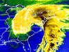
A colorized infrared image of the storm indicates its reach. Image taken March 13, 1993. Click image for larger view.
One of the greatest winter storms in United States’ history, a nor’easter blizzard, struck the eastern third of the nation between March 12 and 14, 1993. The blizzard dumped moderate to heavy snow from Alabama to Maine, accumulating over four feet in some places. Along the track of the storm, residents experienced record low temperatures, record low barometer readings, and heavy winds, sometimes exceeding 100 miles per hour. Eleven tornadoes battered Florida. More than 250 people died. Aviation officials grounded a quarter of commercial flights for a two-day period. And the nation incurred over $3 billion in damage.
Damage and deaths would have been significantly greater if not for newly developed forecast capabilities in NOAA’s National Weather Service. This storm marked the first time all the components of the modernized NWS came together to usher in a new era where numerical weather prediction models would provide great advancements in weather forecasting.
Firsts in Forecasting

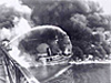
A downed tree and snow-covered automobile attest to the magnitude of snowfall in the Asheville, North Carolina area. Photo taken March 14, 1993. Some of the snowfall totals were: Mt. Mitchell, North Carolina, 50 inches; Grantsville, Maryland, 47 inches; Syracuse, New York, 43 inches. Click image for larger view.
For the first time, National Weather Service forecasters were able to forecast a storm of this magnitude five days in advance and provide storm and blizzard warnings two days in advance. This was unprecedented. The five-day lead time allowed the entire NWS to begin preparations well in advance of the storm and warn the 100,000,000 people in the eastern third of the United States of this impending natural disaster. Prior to the “Storm of the Century,” the technology was not available to warn not only of a storm this far in advance, but also of its expected impacts.
With a level of confidence they had never experienced, NWS forecasters began using terms like “of historic proportions” to describe the impending storm. In turn, this allowed, for the first time, officials such as the governors of New York and the New England states to declare states of emergency prior to the first snow flake falling on their states and take actions to mitigate potential disaster. To accomplish this was a triumph of science, technology, communications and media relations. According to Dr. Louis Uccellini, present head of NOAA’s National Centers for Environmental Prediction, “It was a defining moment in our forecast process, a process that has evolved over the past forty years.”
Models as Bases of the Forecast

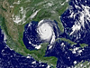
This image is a false color composite of the storm showing the massive sweep of the storm up the eastern portion of the United States. The storm affected nearly one-half the U.S. population and 26 states. Click image for larger view.
Long before the storm formed, NWS forecasters watched as all the necessary atmospheric conditions came together. They did so by peering days into the future using computer forecast models to guide them. Although these models existed since the 1950s, recent advances in the global analyses, numerical modeling, and computing power had increased their resolution and accuracy enough to allow them to play a much greater role in forecasting. Because of the improved models, NWS forecasters were able to make difficult decisions based on the model guidance. This was the first time forecasters were able to do so with such a major weather event.
NWS forecasters issued warnings and advised the public well in advance of the approaching storm. As the storm continued to build, forecasters watched nervously as each model run confirmed their fears. In the end, the storm materialized just as they had predicted.
Pride and Confidence in NOAA Forecasts

Night time satellite image of the Storm of the Century. The cold front from the storm reached down into Mexico's Yucatan Peninsula (lower left). The very narrow, bright line to the west of Florida's Gulf Coast is lightning. In addition to the 270 deaths attributed to the storm, 48 others were missing at sea.
Although the storm inflicted great loss of life and a large economic impact, without the warnings the toll would have been significantly higher. By making this forecast five days in advance and having the confidence to make the forecast known to the public, the National Weather Service raised public confidence in its products and services. By doing so, it distinguished itself as one of the great meteorological organizations of the world.
This storm brought about a fundamental change in the meteorological forecast process. The “Storm of the Century” will long be remembered by the public for a multitude of reasons, but within NOAA’s National Weather Service, it will long be remembered as a major first-time accomplishment. This storm was a watershed event in both NOAA’s science and service to the nation.