
 Surveying—Past and Present
 Instrument Diagrams
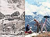 Outdoor Life
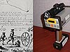 Measuring Distances
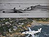 Getting There…
 Surveying Equipment
Outdoor Life
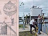
One thing that has not changed about surveying is that you cant do it from the indoors! These two images depict surveyors at work in the field. In the left-hand image, two 18th century surveyors lay out a garden at a rural estate using a plane table. The right-hand photograph, taken in 1980, shows two surveyors from the National Geodetic Survey mapping the wilderness of Alaska using a theodolite.

Surveying produces maps that serve a multitude of purposes, from representing boundaries, to providing information about crustal motion, to allowing safe navigation through coastal waters. Left-hand image courtesy of Treasures of the NOAA Library Collection, archival photographer Sean Linehan. Right-hand image courtesy of Captain Budd Christman, NOAA Corps.
One of the advantages of the profession of surveying is that you get to spend the day outdoors. One of the disadvantages of the profession of surveying can be that you get to spend the day outdoors... it all depends on Mother Nature's mood! But surveying is definitely a craft that can be appreciated by those who love the outdoors, as shown in both these images.
That Was Then…
This frontispiece is from Dupain de Montesson's 1775 manual, "La Science de l'arpenteur: dans toute son etendue," which roughly translates to "The Science of the Surveyor In All Its Extent." The image shows surveyors laying out a garden at a rural estate. A blank map is fastened to the plane table the surveyors are using. In the background, a distance is being measured across the garden. The surveyors will transfer their measurements to the map to produce an accurate plan of the estate.
Dupain de Montesson, who lived from about 1720 to 1790, was a mathematician who specialized in geometry and military tactics. He also published a teaching course on the art of shadows for artists and draughtsmen, together with a short course on drawing for home and field for both civil engineering and military purposes.
…This Is Now
The original mandate to perform a Survey of the Coast has expanded across the United States over the past 200 years and into lands of which little was known in 1807. The great expanse of Alaska, shown in the a 1980s photo, with its lengthy coasts and tremendous natural beauty and resources, now requires surveys of many types to assist in mapping and exploring coastlines and natural resources as well as harbors, airports, and roads and to monitor tectonic activity caused by the state's location on the Ring of Fire.
The crew in the photograph is most likely using classical techniques and equipment to establish horizontal control in support of hydrographic or coastal surveys. Twenty years after the photograph was taken, Global Positioning System technology fills many of Alaska's surveying needs.
About the Images
Past Image
- Date: 1775
- Material: Pen and ink drawing transferred to engraving for publication
- Source: La Science de l'arpenteur: dans toute son etendue, by Dupain de Montesson
- Instrument/technique shown: Measurements of an estate field for mapping purposes
Present Image
- Date: 1980
- Material: Photograph
- Source: Captain Budd Christman, NOAA Corps
- Instrument/technique shown: Theodolite used to position mountain peaks
Works Consulted
Antiquariaat Forum. (2006). "Short Title List With Recent Acquisitions and a Selection from our Stock." Retrieved on September 26, 2006, from http://www.forum-hes.nl/forum/docs/la2006.pdf
Related Web Sites
NOAA's National Geodetic Survey