Going the Distance: A Photo Collection Illustrating the History of Distance Measurement Tools at the National Geodetic Survey
This collection of images traces the evolution of tools used to make extremely accurate distance measurements, from steel bars used in the 1800s to modern global positioning system equipment used today. Underlying this series of images are tales reflecting the brilliance, inventiveness, and determination of the men who created and used each instrument.
- Introduction
- About this Collection
- Measuring Distances: Introduction
- A Brief History of Surveying
- Works Consulted
Ever wonder who marks where one property line stops and another starts? These boundaries were probably designated by a surveyor. Surveying is the science of measuring and mapping relative positions on or above the ground. Surveying has been a part of the human environment since the beginning of recorded history and even today we rely on surveying in transportation, building and construction, communications, and the definition of legal boundaries for land ownership.
The need and desire to measure and map the land for various reasons is an ancient one, and so too is the art and science of surveying. Classical geodetic surveying is based on the geometry of triangles computed on the curved surface of the Earth. Essential to that geometry is knowledge of scale, which is provided by measuring distances of strategically located sides of triangles.
About this Collection
This is a collection of 17 images that illustrate the history and development of the instruments and techniques used to make extremely accurate distance measurements by the U. S. Coast and Geodetic Survey (C&GS), the surveying arm of which was renamed the National Geodetic Survey (NGS) in 1970.
The collection traces the evolution of tools used to measure distances, from steel bars used in the 1800s to modern global positioning system (GPS) equipment used today. As the equipment evolved and became more sophisticated over time, the decrease in cost and increase in ease of taking distance measurements made the measurements more feasible. However, throughout its history, NGS and its predecessor organizations have always maintained the same accuracy and precision required by the first Survey of the Coast Superintendent Ferdinand Hassler in the early 1800s.
All of the instruments shown in the collection are the types and models used by the agency at one time or another. It would be a mistake to think, however, that this is simply a series of pictures of pieces of equipment. Every surveying instrument reflects the brilliance, inventiveness, and sometimes pure determination, of the men who created and used them.
You can browse through the instruments in the collection by clicking on the links to the right or click here to view the items in the Distance Measurement Tools Collection.
Measuring Distances: Introduction

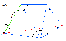
This sketch illlustrates Point A to Point B by way of angles and a measured distance. Distances measured for scale are referred to as "base lines." Click image for larger view.
Those who remember their high school geometry course will find the core of geodetic surveying familiar: given a certain amount of information about the angles and lengths of the sides of a triangle, it is possible to calculate the remaining unknown lengths and angles of the triangle. Given that information and a beginning point whose coordinates are already known ("X,Y" on the high school pop quiz and "latitude and longitude" at NGS), it is possible to build a framework to determine the location of new points by the measurement of new angles and distances.
Classical (pre-GPS) geodetic surveyors measured angles and distances with highly accurate equipment and techniques and performed calculations based on the reality that the measurements were performed on the curved surface of the Earth. In classical surveying, a line of sight is necessary between stations since it is necessary to carefully sight on, or align with, a target during measurements. Until the 1950s, it was also necessary to measure the distances on a line, called a "base line," which had been carefully cleared, graded, and leveled. The distances were then measured by carefully moving metal bars or tapes, usually 15 to 150 feet in length, end-to-end along the complete distance of the base line. Precise measurements of base lines that were typically 6 to 12 miles in length would often take several weeks to complete.
Background: A Brief History of Surveying

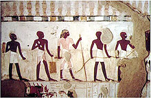
Rope-stretchers carrying out a crop survey under the supervision of the scribe Djerserkereseneb. From the scribe's tomb, dated 1400-1390 B.C. Click image for larger view and image credit.
The Greek historian Herodotus, who lived in the fifth century B.C., relates that around 1400 B.C., the pharaoh Sesostris "distributed the land to all the Egyptians, giving an equal square portion to each man, and from this he made his revenue… and if the river should take away any man's portion… the king used to send men to examine and to find out by measurement how much less the piece of land had become, in order that for the future the man might pay less…" Thus, it appears that the first known reference to the science of surveying shows how it was used to measure property boundaries in order to ensure the collection of taxes or rent at the proper rate.
The measurements that Herodotus referred to were made with ropes in which knots had been tied at pre-determined intervals. To these graduated ropes, Egyptian "harpedonaptae," or rope-stretchers, added plumb bobs and sighting instruments. With these seemingly primitive tools and standardized distances, the rope-stretchers performed surveys of astonishing accuracy.
The Greeks developed the principles of triangulation and instruments to measure angles. The Romans developed a manual of surveying and discarded knotted ropes in favor of more accurate 10-foot-long wooden rods with metal ends, placing them carefully end-to-end along the length of the survey. In 1620, Edmund Gunter invented the surveyor's "chain," which was made up of 100 iron or steel links and was 66 feet long.

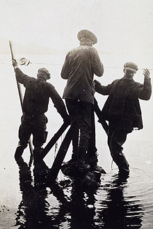
Time and tide wait for no man - or base line measurement. Taping in southeast Alaska as the tide comes in, 1916. Click image for larger view.
By the time Ferdinand Hassler was appointed head of the newly created Survey of the Coast, glass tubes laid end-to-end were being used to measure distances in surveys. The adverse affects of temperature, humidity, and everyday wear and tear on measuring equipment were well known. Hassler, who was passionate about accuracy, cut and standardized four iron bars to exactly two meters in length. He clamped the bars end-to-end to form a rod exactly eight meters in length. This rod was used to measure base lines in the first official survey of the coast of the United States in 1816.
Bars and rods were used by the Coast Survey (originally called Survey of the Coast) for precise measurements for nearly a century after Hassler constructed his iron apparatus. However, bars and rods were cumbersome and slow, so it was undoubtedly a relief when the thermal expansion problem of steel tapes was largely resolved with the discovery of a nickel-steel alloy called "invar."

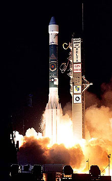
A Boeing Delta 2 rocket carries a global positioning system satellite into orbit. Click image for larger view and image credit.
Distance measurement technology evolved rapidly. Around 1948, the ability to use light to measure distances sparked an explosion in a distance measuring technology. Instruments that measured distances using light were followed by electronic instruments that used microwaves to the same end. This new electronic technology was expensive, but it paid for itself rapidly by eliminating the time and labor needed to locate and prepare specific base line sites. The technology also radically decreased the amount of time needed to measure a distance. Electronic distance measurement instruments (EDMI) were extremely popular and thus rapidly evolved into the highly accurate, fully automatic survey instruments used today. In the 1970s, Doppler satellite signals were used occasionally to add scale and orientation to large survey projects, but the accuracy needed for geodetic surveying was virtually impossible to obtain with Doppler.
The next leap forward in distance measurement technology occurred in 1983, when NGS completed its first survey using GPS technology. This marked the beginning of the days of satellite surveying for the agency, leaving behind nearly 200 years of metal bars, steel tapes, and electronic distance measurements.
Contributed by Cindy Craig, NOAA's National Ocean Service
Works Consulted
Barr, G. W. (2004). History of Surveying. Retrieved May, 2006, from:
http://www.digistar.mb.ca/minsci/surveying/
surv1/unit2/surv2-1.htm.
Brock, J. (2005). Who Were the First Surveyors? FIG, March 2005, Retrieved May, 2006, from:
http://www.fig.net/pub/monthly_articles/
march_2005/brock_march_2005.htm.
Dracup, J. F. (1940). Geodetic Surveys in the United States 1807-1940. Retrieved May, 2006, from:
http://www.ngs.noaa.gov/PUBS_LIB/geodetic_survey_1807.html.
Gill, N. S. (2005). Herodotus History translated
into English. Retrieved May, 2006, from: http://ancienthistory.about.com/library
/bl/bl_text_herodotus_2.htm.
Paulson, J. Surveying in Ancient Egypt. (2005). Proceedings of FIG
Working Week April 2005. Retrieved May, 2006, from:
http://www.fig.net/pub/cairo/papers/
wshs_02/wshs02_02_paulson.pdf.
Root, M. M. Egyptian Surveying Tools. Retrieved May, 2006, from: http://www.surveyhistory.org/egyptian_surveying_tools1.htm.
Topographic Surveys, Inc. What is Land Surveying? Retrieved
May, 2006, from:
http://www.vermessungsseiten.de/englisch/
vermtech/introduction.htm.


