
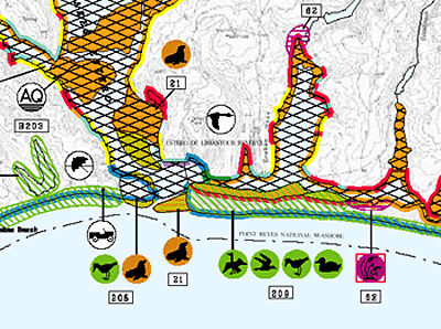
An Environmental Sensitivity Index map, showing part of the Point Reyes National Seashore. Shorelines are color-coded to show their sensitivity to oiling. For example, shorelines shown in red are salt marshes that are especially vulnerable to oil. Symbols mark locations important to spill responders, such as areas where seals or sea lions congregate or breed (marked with a sea lion symbol), areas where different kinds of birds (such as shorebirds, waterfowl, or raptors) concentrate for feeding or nesting, and areas used by people (such as an aquaculture facility, indicated on this map by an "AQ" symbol and a recreational beach, marked by a sun umbrella).