
 New York Bay and Harbor and the Environs
 Hell Gate and Its Approaches
 Pot Rock and Way's Reef, Hell Gate
 New York Bay and Harbor
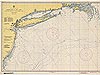 Approaches to New York
 New York Harbor, Upper Bay and Narrows
 Harlem River Nautical
 New York Harbor Nautical
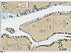 Hudson and East Rivers
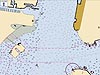 New York City Electronic Navigational Chart
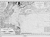
Approaches to New York
This nautical chart depicts Long Island and approaches to New York City. The chart was published in 1944, at the height of World War II and the same year that the battleship USS Missouri was launched from the New York Naval Shipyard.
You may need to download the Flash Player. View the non-Flash version of Approaches to New York (TIF 8.4MB).
The United States was a nation at war when this nautical chart was published. In response to the times, the chart bears an interesting warning to mariners: "Aids to navigation may be altered, interrupted, or removed without notice. In general, temporary changes due to war conditions are not incorporated on the chart."
Other features of note on this chart include abbreviations for the location of lights, buoys, radio towers, and shipwrecks. The chart also includes a table that lists the names of stations with radio beacon signals and descriptions of how the signals might sound. The location of such signals would have been useful to mariners in navigating the waters around New York City, particularly when weather conditions, such as fog, storms, and low-visibility days, made navigating particularly tricky.Historic Reference
The USS Missouri was a 45,000-ton battleship built and launched at the New York Naval Shipyard (also known as the Brooklyn Navy Yard) in January, 1944—the year this nautical chart was published. The Missouri played a prominent role for the remainder of World War II. Arriving in the Pacific war zone in January of 1945, the Missouri supported the Battles of Iwo Jima and Okinawa and raids on Japan's home islands. On September 2, 1945, the Japanese surrendered abroad the Missouri, as she was anchored in Tokyo Bay, marking the end of World War II.
- Chart title: Approaches to New York
- Author: U.S. Coast and Geodetic Survey
- Year published: 1944
- Scale: N/A
- Material: Paper
- Printing technology: Photolithography
- Hydrographic survey technology: Single-beam ecosounder
Related Web Sites
Office of Coast Survey: Historical
Map and Chart Collection
Works Consulted
U.S. Navy, Naval Historical Center. (2000). USS Missouri (BB-63), 1944-1998, Selected Views. Retrieved June 20, 2006, from: http://www.history.navy.mil/photos/sh-usn/usnsh-m/bb63.htm.
(top)