
 New York Bay and Harbor and the Environs
 Hell Gate and Its Approaches
 Pot Rock and Way's Reef, Hell Gate
 New York Bay and Harbor
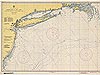 Approaches to New York
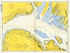 New York Harbor, Upper Bay and Narrows
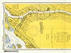 Harlem River Nautical
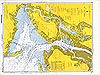 New York Harbor Nautical
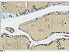 Hudson and East Rivers
 New York City Electronic Navigational Chart
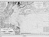
New York Harbor, Upper Bay and Narrows
This nautical chart from 1957 depicts the upper approaches of New York Harbor, including the narrows between Brooklyn and Staten Island. The chart is the first to reflect the renaming of the island that houses the Statue of Liberty from Bedloes's Island to Liberty Island.
You may need to download the Flash Player. View the non-Flash version of New York Harbor, Upper Bay and Narrows (TIF 197MB).
Like all nautical charts, this chart includes information about tides, water levels, and the shape of the coastline. Larger land features, such as buildings, docks, roads, and railways, are prevalent on the chart. Look closely and you'll also see that smaller land features such as flagpoles, elevators, and gas tanks are identified. Even the torch of the Statue of Liberty is identified! The Statue of Liberty is located on Liberty Island, which can be found near the top center of the chart (located at approximately 40°41'N, 74°02'W).
Historic Reference
France gave the Statue of Liberty to the United States in recognition of the friendship established between the two countries during the American Revolution. The statue was constructed in France, dismantled for shipping, and re-assembled on top of an American-built pedestal located on Bedloe's Island. The statue was dedicated on October 28, 1886, by U.S. President Grover Cleveland.
Standing at the mouth of the Hudson River in New York Harbor, slightly over 1.5 miles southwest of Manhattan, the Statue of Liberty has become a symbol of freedom and welcomes all visitors, immigrants, and returning Americans to the United States. Though the Statue of Liberty was accepted by the United States in 1886, the island was known as Bedloe's Island until it was officially renamed Liberty Island in 1956. This nautical chart is the first chart to bear the island's new official name.
- Chart title: New York Harbor, Upper Bay and Narrows
- Author: U.S. Coast and Geodetic Survey
- Contributors: U.S. Army Corps of Engineers and Department of the Navy (revisions and additions)
- Year published: 1957
- Scale: 1:10,000
- Material: Paper
- Printing technology: Photolithography
- Hydrographic survey technology: Single-beam ecosounder
Related Web Sites
Office of Coast Survey: Historical
Map and Chart Collection
Works Consulted
National Park Service. (2006). Statue of Liberty. Retrieved June 20, 2006, from: http://www.nps.gov/stli/prod02.htm.
(top)