
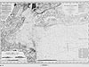
 New York Bay and Harbor and the Environs
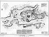 Hell Gate and Its Approaches
 Pot Rock and Way's Reef, Hell Gate
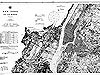 New York Bay and Harbor
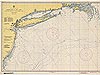 Approaches to New York
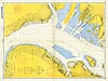 New York Harbor, Upper Bay and Narrows
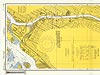 Harlem River Nautical
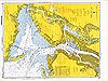 New York Harbor Nautical
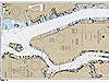 Hudson and East Rivers
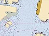 New York City Electronic Navigational Chart
New York City Electronic Navigational Chart
This 2006 electronic navigational chart of the waters around New York City reflects new advances in technology that increase safe navigation.
You may need to download the Flash Player. View the non-Flash version of New York City Electronic Navigational Chart (JPG 564kb).
An electronic navigational chart (ENC) is a digital representation of the paper charts presented in this collection. An ENC is a digital file that contains all the chart information necessary for safe navigation, as well as supplementary information required to plan voyages and avoid groundings. NOAA is the official producer of ENCs for the United States, and supplies these data to mariners, who in turn use the data in electronic charting systems that are installed on the bridges of ships. ENCs are often used by mariners to supplement paper nautical charts.
This chart, as with all ENCs, boasts electronic features that paper charts lack. For instance, a mariner can integrate global positioning system data—which tells a mariner his or her precise latitude and longitude—with ENC data. The mariner can also integrate data from geographic information systems, real-time tide and current data, and wind data to enhance the capabilities of the ENC. Incorporating these features can create a fuller, more accurate picture of the marine environment. A vessel using NOAA ENCs can detect an obstruction in advance and check planned travel routes to avoid crossing hazardous areas. The electronic charting systems used to view ENCs can display warnings and regulations that pertain to areas in which a vessel transits, and can sound an alarm if the vessel's projected course veers too close to a dangerous feature.
- Chart title: New York City Electronic Navigational Chart
- Author: NOAA, National Ocean Service, Office of Coast Survey
- Year published: 2006
- Material: Vector nautical chart
- Hydrographic survey technology: Multi-beam ecosounder
Related Web Sites
Office of Coast Survey, NOAA Electronic Navigational Charts
Works Consulted
National Ocean Service. (2003). NOS electronic navigational charts improve safety at sea. Retrieved June 20, 2006, from: http://oceanservice.noaa.gov/news/features/supp_jul03.html.
Office of Coast Survey. (2005). NOAA Electronic Navigational Charts (NOAA ENCs). Retrieved June 20, 2006, from: http://nauticalcharts.noaa.gov/mcd/enc/index.htm.
(top)