
How NOAA Got Its Feet Wet: The Origin of NOAA's Wet Labs
NOAA's Office of Oceanic and Atmospheric Research operates three research laboratories that focus on oceanic, coastal, and Great Lakes studies. Research conducted at these laboratories provides scientific results to help manage and understand fisheries, conserve and protect our coasts, and build a stronger economy through marine products and businesses such as biotechnology and sustainable aquaculture. NOAA also looks for changes in the oceans due to natural and human activities.
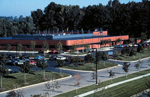
Color aerial photo of the GLERL facility at 2205 Commonwealth Boulevard, Ann Arbor, Michigan, in 1987. Click image for larger view.
Our oceans comprise an astonishing 70 percent of the Earth’s surface, lending our planet its vibrant blue hue from space. More than a century of oceanographic research has revealed that oceans play a critical role in regulating Earth's weather and climate, house extraordinarily diverse plants and animals, provide food and medicines, and significantly influence the creation and ever-changing appearance of our coastlines. Despite these discoveries, we are only beginning to understand how unique our oceans are.
This article traces the history of three of NOAA’s “wet labs,” including the Great Lakes Environmental Research Laboratory in Ann Arbor, Michigan; the Atlantic Oceanographic and Meteorological Laboratory in Miami, Florida; and the Pacific Marine Environmental Laboratory in Seattle, Washington.
The story of these “wet labs” is a twisting tale which crisscrosses the nation and a variety of scientific disciplines. The evolution of each lab’s mission mirrors society’s growing need for more sophisticated environmental information. Today, despite their disparate origins and focuses, scientists at each of these labs work together as part of NOAA’s Office of Oceanic and Atmospheric Research to improve our understanding of the Earth’s complex ocean and coastal systems.
The history of these labs is rich and diverse, beginning in 1807 with founding of the Survey of the Coast by President Thomas Jefferson.
The Great Lakes
The story of the Great Lakes Environmental Research Laboratory (GLERL) begins in the early 1800s, with the boom in commercial transportation on the Great Lakes, driven by the nation’s push westward.
The Lake Survey
In 1841, Congress created the Lake Survey within the U.S. Army Topographical Engineers, which later became part of the U.S. Army Corps of Engineers. The Survey, based in Detroit, Michigan, was charged with conducting a hydrographical survey of the Northern and Northwestern Lakes and preparing and publishing nautical charts and other navigation aids. The Lake Survey published its first charts in 1852. In 1882, after producing 76 charts and completing its Congressional mandate, the Survey was disbanded.
As technology evolved and deeper-draft vessels were created, Congress reconstituted the Lake Survey in 1901, to produce revised charts with deeper depths to allow the new deeper-draft vessels to safely navigate waters. At the same time, the Survey’s mission expanded to include the lakes and navigable waters of the New York State Barge Canal System, Lake Champlain, and the Minnesota-Ontario Border Lakes.
The Lake Survey also carried out support activities such as studies on lake levels and river flows. Survey water level and precipitation gauges allowed engineers to forecast lake levels six months in advance.
In 1962, the Great Lakes Research Center was established to expand these monitoring efforts. The Research Center conducted scientific investigations in limnology (fresh water processes), coastal engineering (currents, tides, waves, and shore processes such as sedimentation), and water resources (water quality and quantity and ice and snow conditions). This work was supported by a suite of facilities including the Great Lakes Regional Data Center, a Technical Library and Instrument Office, an Ice and Snow Laboratory, a Chemical Laboratory, and a Sedimentation Laboratory.
The Great Lakes Environmental Research Laboratory
Following the formation of NOAA in 1970, the Lake Survey became part of the new agency and was renamed the Lake Survey Center. The Great Lakes Environmental Research Laboratory (GLERL) took over Lake Survey limnological and research operations in 1974. This laboratory was formed from the combination of staff from the International Field Year for the Great Lakes and the Limnology and Computer Divisions of the Lake Survey Center. Dr. Eugene Aubert served as the Center’s first Director.

R/V Huron Explorer at the Lake Michigan Field Station, Muskegon, Michigan.
Today, the GLERL focuses on conducting high-quality research and providing scientific leadership on issues that are important both to the Great Lakes and marine coastal environments. This research has led to new knowledge, tools, approaches, awareness, and services.
“From lake levels to invasive species to ice cover, NOAA scientists in Ann Arbor conduct research on practically every drop of water in the Great Lakes,” said Tim Keeney, deputy assistant secretary for oceans and atmosphere. “Their efforts have helped us better understand these natural resources that are enjoyed by millions of people for their beauty and economic opportunities.”
From the Atlantic to the Pacific…
As with GLERL, the Atlantic Oceanographic and Meteorological Laboratory and the Pacific Marine Environmental Laboratory grew out of a survey organization.
After World War II, returning officers in the Coast and Geodetic Survey (C&GS) who had served overseas during the war were tasked with surveying and defense projects, including sailing on oceanographic cruises for the Navy. By 1959, the connection between the U.S. environment and the world environment was clear, and worldwide oceanographic studies became part of the C&GS mandate. Subsequently, the C&GS research and development division was created.
The Western Oceanographic Research Laboratory was created in 1963 to process data, perform direct current measurements, and conduct geophysical observations. A year later, the name of the lab was changed to the Marine Science Center and its research was divided into two theme areas: physical oceanography and marine geophysics. Early projects included preparing a data report on the International Indian Ocean Expedition and studies of sediment cores from the Gulf of Alaska and the Indian Ocean Expedition.
The Institute of Oceanography
In 1966, the Institute of Oceanography was created within the Environmental Science Services Administration (ESSA), NOAA’s immediate predecessor organization. ESSA was formed in part to provide a single focus for the nation’s efforts to describe, understand, and predict the state of the oceans. Dr. Harris B. Stewart, an oceanographer in the Coast and Geodetic Survey’s Division of Tides and Currents, was appointed as the Institute’s director and his staff was drawn largely from the research and development division of the C&GS.

Dr. Harris B. Stewart, Chief Oceanographer of the Coast and Geodetic Survey, explains the operation of the Nansen Bottle to Ceylonese scientists visiting the C&GS ship Pioneer during the International Indian Ocean Expedition.
The Institute’s principle laboratories focused on the role of oceans in climate and regional ecosystem issues. These labs included the Marine Geology and Geophysics Laboratory, the Physical Oceanography Laboratory, and the Sea-Air Interaction and Land and Sea Interaction facilities.
Under ESSA and the Institute of Oceanography, various new research groups were formed, including the Pacific Oceanographic Laboratory, the Joint Oceanographic Research Group at the University of Washington, and the Joint Tsunami Research Effort at the University of Hawaii. The formation of these groups reflected a growing desire to study and understand our oceans.
The Atlantic Oceanographic and Meteorological Laboratory
To coordinate research efforts, the Institute labs merged into the “Atlantic Oceanographic Laboratories” in 1967. Following this merger, more than 100 marine researchers relocated to new offices in Miami, Florida. Just a year later, in 1968, two meteorological groups were added and the labs became known as Atlantic Oceanographic and Meteorological Laboratory (AOML). This name is still used today.

Aerial view of NOAA AOML facilities on Virginia Key. The city of Miami can be seen in the background. Click image for larger view.
In the early years, AOML research focused on subtropical and tropical atmospheric and oceanic interaction. For example, the Barbados Oceanographic and Meteorological Experiment of 1969 focused on the interaction between the atmosphere and ocean in the subtropics and tropics.
Today, AOML scientists use basic and applied research to understand the physical, chemical, and biological characteristics and processes of the ocean and atmosphere, both separately and as a system. This focus is designed to strengthen ocean and weather services by improving severe storm predictions, use and management of marine resources, and understanding of factors contributing to environmental and climate quality.
The Pacific Marine Environmental Laboratory
Following the formation of NOAA, the Pacific Oceanographic Laboratory was reorganized into the Pacific Marine Environmental Laboratory (PMEL) with the staff from the original lab and personnel from the Marine Minerals Technology Center.
PMEL carries out interdisciplinary scientific investigations in oceanography. Current programs focus on open ocean observations in support of long-term monitoring and prediction of the ocean environment. PMEL scientists conduct studies to understand the world’s oceans; define the processes driving the global climate system; and improve environmental forecasting capabilities for public safety, marine commerce, and fisheries.
Conclusion
The creation of NOAA in 1970 served to unite the scientists of the Great Lakes Environmental Research Laboratory, Atlantic Oceanographic and Meteorological Laboratory, and the Pacific Marine Environmental Lab—sparking a new era of collaboration. Today, NOAA research on the major bodies of water that affect the United States helps increase understanding of these complex systems and improve NOAA’s ability to issue more accurate and timely environmental predictions.
Contributed by Erica Rule and Cassandra Lopez, NOAA's Office of Oceanic and Atmospheric Research
Works Consulted
NOAA. (2004). NOAA Great Lakes Laboratory Celebrates 30 Years of Research, April 22, 2004 NOAA Press Release. Retrieved July 2006, from: http://www.publicaffairs.noaa.gov/releases2004/
apr04/noaa04-r516.html.
Office of Public Information, U.S. Department of Commerce, Environmental Science Services Administration. (1970). ESSA, Volume 5, Number 4. October 1970. Rockville, Maryland.
Woodford, A. M. (1991). Charting the Inland Seas: A History of the U.S. Lake Survey. Detroit District: U.S. Army Corps of Engineers. Retrieved July 2006, from: http://www.glerl.noaa.gov/about/history.