 Great Theodolite
 The Bache- Wurdemann Compensating Device
 Eimbeck Duplex Bars
 Iced Bar B 17
 Steel Tape with Tape Stretcher
 Invar Tape
 AGA Geodimeter NASM-2A
 Tellurometer Model M/RA 1
 Laser Signal and Prismatic Mirror Reflecting System
 AGA Geodimeters, Models 4D and 4L
 Big Red
 AGA Geodimeter Model 6
 Hewlett-Packard Model 3800B Distance Meter
 Tellurometer Model MA-100
 Ranger III and Rangemaster III
 Topcon ET-1 Total Station
 Trimble GPS Antenna
Great Theodolite
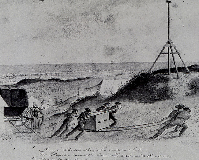
This black and white illustration, included to give an idea of some of the challenges of the equipment of the era, shows Survey of the Coast Superintendent Ferdinand Hassler directing the placement of his specially designed "Great Theodolite" while surveying on Fire Island, New York. The theodolite was used for precise and accurate angle measurements. He also designed and built an apparatus consisting of four two-meter bars that could be laid end-to-end to determine distance.

No sketch of the base line apparatus is available, but this sketch, probably by Assistant John Farley, shows how cumbersome Hassler's equipment was. On the left is a carriage that Hassler had specially built to carry equipment.
The measurements conducted at Fire Island, New York in 1834 by Ferdinand Hassler resulted in Hassler's longest and most accurate base line. It was also the last base line that Hassler measured in his career. For this line, Hassler, who was passionate about accuracy, used a standardized eight-meter iron rod apparatus that he created. This rod consisted of four two-meter bars, clamped end-to-end to form a rod exactly eight meters in length.
The bar was supported in a wooden trough constructed specifically for the measurements at Fire Island. To measure distances, the bar was moved forward in a straight line, with the beginning of one rod lined up with the end of the other rod. Since the length of the rod was known, it was possible to determine distance covered by counting the number of times the bar was moved.
To ensure an accurate distance reading as the apparatus was moved forward, a strand of spider cocoon silk was stretched across a semicircular opening at the front end of the bar. This silk strand was lined up with the image of two intersecting lines drawn on a plate of ivory. The ivory plate was in turn attached to a microscope, which was fixed on a stand separate from the trough and rod. To measure a distance, the rod was carried forward to a new position and the silk strand at the end of the apparatus was lined up with the same point on the ivory plate.
To measure the Fire Island base line, this operation was repeated some 1,800 times, over 45 days, for a final total of 8.73 miles!
No sketch of the base line apparatus is available, but this sketch, probably by Assistant John Farley, shows how cumbersome Hassler's equipment was. His carriage, which was specially built to carry delicate equipment, is visible on the left.
Historical Reference
Swiss geodesist Ferdinand Hassler brought brilliance and a drive for accuracy and precision to the office when he was appointed head of the Survey of the Coast. He ordered the best instruments crafted to his specifications from England and had a special carriage and boxes built to protect the delicate equipment during transportation.
Hassler's first two distances were measured in 1816 and 1817, at Gravesend Bay, near present-day Coney Island, New York and Englewood, New Jersey. These base lines were measured with iron chains, each link one meter in length. The measured distances were 4.7 miles and 5.8 miles, respectively.
- Distance Measurement Instrument Shown: No picture available
- Location: Fire Island, New York
- Manufacture Date: Approx. 1816
- Dates of Use: 1834-1844
- Photo Date: 1836?, sketch, probably by Assistant John Farley
Works Consulted
Dracup, J. F. Geodetic Surveys in the United States 1807-1940. Retrieved May 2006, from: http://www.ngs.noaa.gov/PUBS_LIB/geodetic_survey_1807.html.
Lienhard, J. H. (2006). Measuring America. Retrieved May 2006, from: http://www.uh.edu/engines/epi365.htm.
Theberge, Capt. A. E. (NOAA CORPS, Retired) (2001?) The Coast Survey 1807-1867. Retrieved May 2006, from: http://www.lib.noaa.gov/edocs/CONTENTS.htm#CONTENTS.
Related Web Sites
