 Lewis and Clark Corps of Discovery Bicentennial
 2002 Winter Olympics – Salt Lake City
 U.S. Center of Population: 2000
 NOAA Heritage Trail: The Calais Observatory
 Ocean in View! The Nation's Newest Nickel
 100th Anniversary of the First Flight
 50th Anniversary of the Fredericksburg Geomagnetic Center
 Fagatele Bay National Marine Sanctuary, American Samoa
 Pago Pago Harbor, American Samoa
 Kilauea Point National Wildlife Refuge, Hawaii
 Hassler Park
 100th Anniversary of the U.S. Forest Service
 National Estuarine Research Reserve System
 Hawaiian Islands Humpback Whale National Marine Sanctuary
50th Anniversary of the Fredericksburg Geomagnetic Center
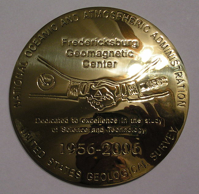
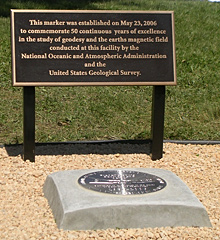
This commemorative disk was set at the Fredericksburg Geomagnetic Center in Corbin, Virginia, on May 23, 2006, at a special ceremony to celebrate 50 years of service by NOAA and the U.S. Geological Survey.

On May 23, 2006, NOAA and the U.S. Geological Survey, who jointly run the site, celebrated 50 years of the study of geodesy and the Earth's magnetic field at the Fredericksburg Geomagnetic Center (FGC) in Corbin, Virginia.
The research center and observatory were established in 1956 to continuously monitor the Earth's magnetic field. The Center was charged by Congress "to enhance geomagnetic field studies and monitoring programs in support of scientific, general public, basic and national security needs of the United States."
Significant milestones for the Center over the past 50 years have included:
- establishing U.S. and international magnetic standards;
- calibrating National Aeronautic and Space Administration (NASA) satellite magnetometers and magnetometers for the U.S. and agencies worldwide;
- developing electronic distance measurement instruments; and
- establishing the Global Positioning Antenna Phase Center that calibrates global positioning system (GPS) antennas.

The marker set at the Fredericksburg Geomagnetic Center was established on May 23, 2006, to commemorate 50 continuous years of excellence in the study of geodesy and the Earth's magnetic field conducted at this facility by the NOAA and the U.S. Geological Survey.
In 1973, NOAA's earthquake research and engineering seismology programs, including personnel, real property, equipment, and other program assets, were incorporated into the U.S. Geological Survey. Since then, NOAA has leased office space from the U.S. Geological Survey to continue its geodesy-related operations at the facility. However, during the dedication of the commemorative mark in 2006, the U.S. Geological Survey transferred 144 of 187 acres of the facility back to NOAA.
Currently, the FGC houses some of NOAA's geodetic infrastructure, including the Instrumentation and Methodologies Branch. The Center serves as a site for GPS antenna calibration, geodetic leveling support, and base line calibration, among other activities. In addition, NOAA will establish the National Ocean Service National Geodetic Survey Calibration and Training Center on the site to serve its state geodetic advisory program. This program supports the official National Spatial Reference System from which official land boundary surveys are made.
Historic Reference
The Center is part of a network of 14 U.S. Geological Survey magnetic observatories in the U.S.—seven in the contiguous U.S.; four in Alaska; and one each in Hawaii, Puerto Rico, and Guam. About 200 stations worldwide are operated by partner agencies to observe variations in the Earth's magnetic field in time and space; to precisely calibrate instruments; and to monitor hazards to communication, navigation, and power grids from "space weather."
The first magnetic observatories were established in the early 1800s as a part of Thomas Jefferson's vision of surveying the new nation. Today, they are found in places like Barrow, Alaska; Midway Island in the Pacific Ocean; and Thule in northern Greenland.
The science of geomagnetism and these observatories serve many customers, including government agencies such as NOAA's Space Environment Center in Boulder, Colorado; the U.S. Air Force Weather Agency; laboratories in the U.S. and abroad; and a wide array of academic, government, and private scientists engaged in both applied and pure research science. The products resulting from this science are part of our everyday lives, important for anyone navigating anything. From hikers trying not to get lost, to airline pilots or ship captions, to aircraft carriers seeking their destination, the science of accurate positioning is critical.
- Designation: Not yet in database
- PID: Not yet in database
- Year: 2006
- Location: Fredericksburg Geomagnetic Center, Corbin, Virginia
- Latitude/Longitude: Not yet in database
- Event Commemorated: 50th anniversary of the Fredericksburg Geomagnetic Center
Related Web Sites:
USGS, NOAA Mark 50 Years of Geomagnetic Research
U.S. Geological Survey Geomagnetism Program
