The National Status and Trends Program: America's Barometer for Coastal Contamination
NOAA's National Status and Trends Program was initiated to determine the health of the waters found along our coastlines and in our estuaries. By sampling sediments and bivalves, researchers can measure the extent of chemical contamination and determine whether efforts to improve waters are having any effect. The results of this program provide information needed to improve coastal health.
- Introduction
- Integrating Knowledge
- Science of Contaminant Monitoring
- Information Sharing
- Looking to the Future
- Works Consulted
Blue mussels and sea weed at an Alaska Mussel Watch site. Click image for larger view.
NOAA's responsibility to the environment is vast and includes checking our coastlines for pollution (contaminants) introduced by human activity. One way NOAA does this is through the National Status and Trends (NS&T) Program. The NS&T program regularly reports the trends in levels of contaminants in the coastal environment and in certain organisms, like mussels and oysters, over distances and over time.
Started in 1984, NS&T is the only long-term coastal and estuarine contaminant monitoring effort in the U.S. One component of the NS&T Program, the Mussel Watch Project, started in 1986, is the longest continuous contaminant monitoring effort ever conducted in the country. This article traces the evolution of this program, which provides information vital to evaluating the health of the nation's coastal waters, and the progress being made towards improving overall environmental quality.
Integrating Old Knowledge with the New
Documenting the contamination of the waters along our nation's coast is a daunting task. Literally thousands of contaminants enter our coastal ecosystems every day through urban and suburban storm drains, run-off from fields and farms, and directly from industrial and municipal waste discharges. The challenge is to identify those chemical contaminants of greatest concern and their concentration in the environment, and if possible, determine if contaminant levels are increasing or decreasing over time.
In 1984, there was no national program for documenting contaminants in coastal waters. The U.S. Mussel Watch Program, sponsored by the U.S. Environmental Protection Agency (EPA), ended in 1979. Although some states such as California had started their own Mussel Watch, the end of the EPA's effort meant there was no national effort.
Filling a Gap
To fill the monitoring gap, in 1984, NOAA initiated the National Status and Trends (NS&T) Program. The program was established to determine the current status of, and trends in, the environmental quality of our nation's estuarine and coastal waters.
The NS&T Mussel Watch Project was patterned after the EPA's Mussel Watch Program, the California State Mussel Watch Program, and the monitoring program developed by the Bureau of Commercial Fisheries. NOAA used some of the same sites established by these earlier projects and expanded to other coastal states to provide a more comprehensive national assessment. Using existing sites resulted in a longer record of environmental contamination-some areas now have a contaminant record of over 40 years' duration.
The Mussel Watch Project began taking samples of oysters and mussels in 1986, at carefully chosen sites across the United States. Oysters and mussels are used because they stay in one place over long periods of time and tend to accumulate chemical contaminants in a consistent way. Researchers can thus determine the source of contaminants entering animals and compare samples taken thousands of miles apart. Scientists also collect sediment samples, which can be used to show current and historic levels of contamination.
Once analyzed, these samples can help determine if major legislation, such as the Clean Air Act, the Clean Water Act, and the Organotin Antifoulant Paint Control Act, are having their intended effect of reducing pollution in the environment.
Expanding and Enhancing the Science of Contaminant Monitoring
Since the start of NOAA's Mussel Watch Project, a series of tools and techniques have been refined, allowing researchers to better document coastal contamination.
Contaminant Analysis
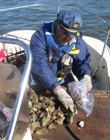
Scientists in the field packaging oysters for shipment back to the laboratory where they are analyzed for contaminants. Click image for larger view.
During the first year of sample collection for NOAA's Mussel Watch Project, mussels, oysters, and sediments were collected from 145 sites. The samples were analyzed for both organic contaminants, such as those that come from petroleum products, and inorganic contaminants, such as mercury. Scientists analyzed samples for approximately 80 chemical contaminants in 1986.
Today, the number of contaminants routinely analyzed in the Mussel Watch Project has grown to around 170 and improved technology enables detection of even lower concentrations. Samples are collected from over 280 sites across all 50 states and Puerto Rico.
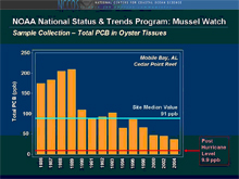
Mussel Watch trends data for the site located in Cedar Point Reef in Mobile Bay, Alabama. Data are provided for all years that samples were collected, including data from post-Hurricane Katrina sampling. Click image for larger view.
The Mussel Watch Project has been invaluable for documenting the decrease of regulated contaminants in estuarine and coastal waters, such as the pesticide dichloro- diphenyl-trichloroethane (DDT), polychlorinated biphenyls (PCBs), and the anti-foulant paint additive tributyltin, which was used to prevent the growth of algae and barnacles on the hulls of boats. Samples continue to be analyzed for oil-related compounds, important for determining background levels in the event of an oil spill.
Expanded Data Applications
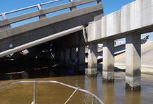
Sampling oysters at the Mussel Watch site in Biloxi Bay, Mississippi, under a collapsed highway after the passage of Hurricanes Katrina and Rita. Click image for larger view.
The versatility of the Mussel Watch data became even more apparent when they were used to help determine the extent of environmental degradation in the aquatic environment following the September 11, 2001 collapse of the World Trade Center. Mussel Watch data were also used to help determine the environmental impacts of Hurricanes Katrina and Rita in 2005. Currently, a major concern from a human health perspective is the extent to which the U.S. population is exposed to the flame retardants known as polybrominated diphenyl ethers, or PBDEs, which are now being actively assessed by the Mussel Watch Project.
Laboratory Coordination
In order to compare the data generated by the Mussel Watch Project with those of other programs, and to have confidence in the information generated by different Mussel Watch Project contractors over the years, it is essential that the data generated are of the highest quality. One of the best ways of ensuring this is to conduct what have become known as "interlaboratory calibration exercises." In 1984, there was no coordinated effort to conduct these exercises. In 1985, the NS&T Program organized and then began running these calibration exercises, to verify that laboratories (e.g., Mussel Watch Project laboratories and others) analyzing samples using a variety of analytical methods could achieve comparable results. These annual inter-laboratory exercises are still run today to ensure that monitoring data are comparable across laboratories and across the decades of environmental monitoring.
Sharing this Valuable Information with the World
Today, NS&T data are available to national and regional environmental managers throughout the U.S. and abroad. The most popular way to access this data is through the NS&T Web site. The Web site not only provides access to the data, but also offers the user a series of online analytical tools.
The Mussel Watch Project database alone currently contains over 750,000 records. The dataset and the sample archive that have resulted from the monitoring effort provide a powerful tool to determine both current and past contaminant impacts on the environment.
With resulting information, managers can take appropriate corrective steps when environmental problems are identified or take steps to minimize future environmental harm. The data have also helped define the environmental health of marine protected areas, including nearly all of the National Estuarine Research Reserves and a number of National Marine Sanctuaries. Because of the national coastal coverage of the project, additional local applications of the data have been found as well.
Building on a Robust Past as We Look to the Future
Overall, NOAA's NS&T Program has been instrumental in advancing the science of environmental contaminant monitoring. In particular, it has led the environmental field in:
- fostering the development of standard reference materials specific to marine matrices, which allow for environmental data to be compared across different contaminant monitoring programs;
- establishing, with the National Research Council of Canada and with the National Institute of Standards and Technology, national and international interlaboratory calibration exercises;
- promoting performance-driven quality assurance methods, rather than remaining tied to static-defined methods;
- determining the extent of antifouling paint and flame retardants (PBDEs) contamination in the nation's estuaries; and
- establishing and maintaining the nation's longest continuous coastal and estuarine contaminant dataset.
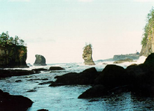
Mussel Watch site at Cape Flattery, Washington. Click image for larger view.
At the end of 2006, we were proud to say that the NS&T Mussel Watch Project had completed its 21st year of sampling and begun work for 2007. The analysis of the samples taken from the over 280 sites across all 50 states and Puerto Rico has begun to yield information about coastal pollution over vast spaces and time. This information, in turn, is helping coastal managers make the very best choices possible when it comes to developing new policies and approaches to manage their resources. The wise management of these resources, in the end, benefits us all.
Contributed by John Christensen, Gunnar Lauenstein, and Tony Pait, NOAA's National Ocean Service
Works Consulted
NOAA, (1998). NS&T Program: National Status and Trends Program for Marine Environmental Quality. NOAA/NOS/NCCOS. Silver Spring, MD. 32pp.
O'Connor, T., & Lauenstein, G.G. (2006). Trends in chemical concentrations in mussels and oysters collected along the US coast: Update to 2003. Marine Environmental Research, vol 26, pp. 261-285.
