
History of Tornado Forecasting
Forecasting of tornadoes and other severe storms by NOAA scientists has had varying levels of success throughout the years. NOAA's National Weather Service and its predecessors have predicted and warned communities of these severe weather threats with ever-increasing accuracy, saving countless lives and billions of dollars.
- Introduction
- Early Advances
- Expanding Knowledge
- Continued Research
- Tornado Forecasting Today
- Works Consulted
Tornadoes are one of nature's most violent storms. In an average year, about 1,200 tornadoes are reported across the United States, resulting in 80 deaths and more than 1,500 injuries. Click image for larger view.
Thunderstorms can be majestic, picturesque figures in the sky, inspiring awe in those who view them. Tornadoes can instill the same feelings, yet can also invoke fear and fright.
Imagine early explorers of the New World, traveling westward across America and encountering many new sights and experiences. These explorers would see and hear thunderstorms and experience hail, strong hurricane-force winds, and tornadoes for the very first time. Did they think these acts of nature were works of the devil or acts of God?
The first possible tornado report in the United States occurred in July 1643 in Lynn, Newbury, and Hampton, Massachusetts, documented by author David Ludlam. The report was recorded by Massachusetts Governor and weather enthusiast John Winthrop, who observed a sudden gust that whipped up dust, lifted his meeting house, and killed a nearby observer with a fallen tree.
This article looks at how, over the years, our understanding of and ability to forecast tornadoes has dramatically increased.
Early Advances
In 1882, after nearly 300 years of numerous observations and stories of whirlwinds, cyclones, and tornadoes, U.S. Army Signal Corps Sergeant John P. Finley was placed in charge of the investigation of tornadoes and the development of forecasting methods. During a tornado outbreak that occurred on February 19, 1884, Finley established 15 rules for early tornado forecasting. In 1888, Finley published these rules, which identified signs that the formation of a tornado was likely.
Unfortunately, as Finley was developing his techniques, the tornado prediction program encountered a huge road block. The word "tornado" was banned from official forecasts by the U.S. Army Signal Corps due to limitations with the observing network and concerns over causing mass panic among the general public.
The Tri-State Tornado
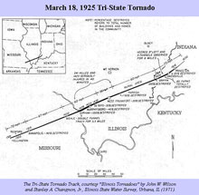
This image shows the path of the Tri-State Tornado, which continues to be the most single-damaging, most fatal, and longest-tracking tornado on record. The tornado was on the ground for 3.5 hours, completely destroying four towns. Click image for larger view.
The ban on the use of the word "tornado" continued for four decades, into the early 20th century. During that time, one of the biggest, longest-tracking tornadoes occurred. Known as the Tri-State Tornado, this tornado touched down on March 18, 1925, beginning southwest of Ellington, Missouri. The tornado tracked for 219 miles across southern Illinois into southwest Indiana, killing 695 and injuring 2,000 people.
Alfred J. Henry, Editor of the Monthly Weather Review, described the conditions that occurred with the Tri-State Tornado. Nine of the fifteen rules listed by Finley appeared in Henry's analysis. Finley's work did thus enable forecasters at the time to recognize the possibility for tornadoes, although they were not able to predict the twister in advance.
Expanding Knowledge
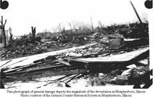
This photograph depicts the magnitude of devastation in Murphysboro, Illinois, following the 1925 Tri-State Tornado. Click image for larger view and credit.
Even after the Tri-State Tornado, the word "tornado" continued to be ill-advised, thus deterring tornado research. In 1942, the central areas of the country experienced a large number of tornadoes. Reports indicate that 132 tornadoes killed 223 people and caused just over seven million dollars in damage. This destruction pointed to the need to warn the public on the possibility for tornadoes.
In the spring of 1943, the Weather Bureau formed experimental tornado warning systems in Wichita, Kansas; Kansas City, Missouri; and St. Louis, Missouri. In June 1944, reporting by local weather observers was expanded to include tornadoes, thunderstorms, hailstorms, lightning, and high winds. Forecasters could make advanced weather forecasts indicating that conditions were favorable for severe storms over a general area, but they could not give, in advance, an exact time or place where severe weather might occur.
Fawbush and Miller
Research into tornado forecasting continued, building greater understanding into tornado formation. A major breakthrough occurred in the late 1940s, when Major Ernest J. Fawbush and Captain Robert C. Miller of the U.S. Air Force worked on observational and experimental techniques for predicting severe storms and tornadoes. On March 20, 1948, a tornado struck Tinker Air Force Base in Oklahoma City, destroying 32 military aircraft and causing $10 million in damage.
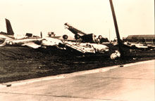
Airplanes thrown about like toys by the tornado that, onMarch 20, 1948, struck Tinker Air Force Base, Oklahoma. Click image for larger view.
Five days later, Fawbush and Miller recognized a similar weather pattern establishing itself over the southern half of the Plains states. Based on their observations, the first tornado forecast was issued and a Tornado Safety Plan for Tinker Air Force Base was put into effect. A tornado ended up striking the base again just after 6:00 p.m. This time, the tornado caused six million dollars in damage, but nobody was killed and the forecast and the safety plan were considered successful.
While the successes of Fawbush and Miller brought attention from the public and local media, forecasts were only available to Air Force weather offices. New ideas like those presented by Fawbush and Miller were met with skepticism, being challenged and experimented on by other forecasters in the Air Force and Weather Bureau.
The Tornado Project
Developments and advancement in the application of radar were made during World War II to detect enemy warships and aircraft. Sometimes the radar images would be obscured by rain, which introduced the possibility of using radar in weather forecasting.
In 1950, the Tornado Project was conducted across Kansas and Oklahoma and included an observational network of 134 stations and 34 cooperative stations. Radar coverage for the project was provided by the Weather Bureau in Wichita, Kansas, and Norfolk, Nebraska, and by the Air Weather Service at Offutt Air Force Base near Omaha, Nebraska; Sherman Air Force Base near Fort Leavenworth, Kansas; and Vance Air Force Base in Enid, Oklahoma.
Sounding analysis of data from radiosondes and rawinsondes that started with the Tornado Project became a principal forecasting tool.Continued Research
Tornado outbreaks in Missouri, Arkansas, and Tennessee on March 21,1952, killed over 150 people and led to public outcry and Congressional pressure for the issuance of tornado forecasts. As a result, the Severe Local Storms (SELS) Center was established within the Weather Bureau in June 1953. SELS developed a checklist for forecasting tornadoes that included the basic parameters founded by Fawbush and Miller. This checklist, known as the Lifted Index, became the basis for evaluating potential instability for many decades to come.
Continued research shed new light on the conditions present when tornadoes form. The results of various individual research projects were combined in 1955 to produce a manual for SELS Forecasting Procedures, the first known publication in forecasting severe thunderstorms. This manual would be expanded and its contents debated and argued to produce the first publicly issued document: Forecasting Guide No. 1: Forecasting Tornadoes and Severe Thunderstorms.
The Palm Sunday Outbreak
The famous Palm Sunday Outbreak occurred on April 11-12, 1965, beginning over parts of Iowa, Minnesota, and southern Wisconsin, and spreading through northern Illinois and Indiana into northern Ohio. At the time of the outbreak, the Weather Bureau had WSR-57 radars and the TIROS VIII satellite images available for forecasting.
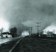
The 1965 Palm Sunday tornado outbreak was a turning point for the National Weather Service. A massive double-funnel tornado near Dunlap, Indiana, between Goshen and Elkhart, tore up everything in its path. Click image for larger view and credit.
Despite these technologies, the Palm Sunday Outbreak killed 271 people and caused $200 million in damage. While SELS was issuing tornado watches for areas where tornadoes could occur, it was difficult for Weather Bureau offices to communicate with each other and to deliver timely information to media outlets to warn of approaching storms. Checklists developed by Fawbush and Miller, techniques to evaluate air masses, and advances in research and theories were all helpful in understanding where severe weather and tornadoes could occur, but jammed telephone lines made it difficult to deliver advanced warning and information to the public.
Work continued at the Techniques Development Unit of the National Severe Storms Forecast Center in Kansas City, Missouri, as well as the National Severe Storms Laboratory in Norman, Oklahoma. Forecasts were gradually improving with studies of the Palm Sunday Outbreak and discussions on concepts of storm structure.
In 1972, the U.S. Air Force published a series of guidelines known as "Miller's Rules." Written by Captain Robert Miller, this publication became the main reference for severe weather forecasting in all corners of meteorology, laying down guidelines for weather analysis as well as the use of different symbology for marking severe storm and tornado conditions. The publication also explained forecasting parameters for tornadoes, large hail, and convective wind gusts.
Future work and case studies stemmed from this document. Miller's Rules propelled severe weather and tornado forecasting forward, allowing the expertise shared by Fawbush and Miller to be shared and expanded by aspiring severe weather forecasters and enthusiasts.
The F-Scale
Around the time that Miller's Rules were published, Dr. T. Theodore Fujita introduced the F-Scale that uses the damage caused by a tornado to estimate its wind speed. Fujita's scale included six levels of tornado intensity, from F0 to F5, and connected tornado damage with the wind scale of the Beaufort scale, developed by Admiral Beaufort of the British Navy in the early 19th century.
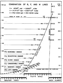
Fujita's logarithmic chart for classifying tornadoes. Click image for larger view.
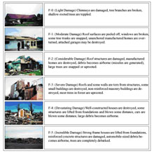
The Enhanced Fujita Scale, implemented in February 2007, is used by meteorologists to rate tornado damage on a scale from EF0 to EF5. The EF Scale incorporates more damage indicators and degrees of damage than the original Fujita Scale, allowing more detailed analysis and better correlation between damage and wind speed. Click image for larger view.
The Super Outbreak on April 3-4, 1974, set present-day records with 148 tornadoes occurring in 13 states in a matter of 16 hours. The tornadoes from this outbreak caused 315 deaths and nearly 6,000 injuries. Damage was estimated at $600 million. Fujita and his staff surveyed the damage by land and air, rating every tornado path found using the F-Scale.
When NOAA published "Natural Disaster Survey Report 74-1, The Widespread Tornado Outbreak of April 3-4, 1974," the F-Scale became the foundation on which all past and future tornadoes would be evaluated. The Techniques Development Unit of the National Severe Storms Forecast Center hired students to read publications and newspaper articles on tornadoes since 1950 and to assign F-scale damage ratings to these twisters.
Today, tornado damage is assigned a rating based on the worst damage along the tornado's path. However, the original Fujita Scale was replaced in February 2007 with the refined and improved Enhanced Fujita Scale (EF Scale). The EF Scale continues to rate tornadoes on a scale from zero to five, but ranges in wind speed on the scale are more accurate. The EF Scale still estimates wind speeds, but more precisely takes into account the materials affected and the construction of the structures damaged by the tornado. This rating becomes significant as many of today's forecast techniques are compared to the potential of tornadoes producing EF2 damage or worse.
Tornado Forecasting Today
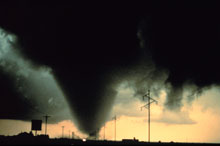
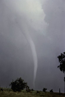
A tornado is a violently rotating column of air extending from a thunderstorm to the ground. The most violent tornadoes are capable of tremendous destruction with wind speeds of 250 miles per hour or more. Damage paths can be in excess of one mile wide and 50 miles long. Click image for larger view.
Continued research and advancements in computer technology from the 1960s through the 1990s improved severe weather and tornado forecasting. Meteorologists were soon able to develop numerical weather prediction models and technology. Projects at organizations like the National Severe Storms Laboratory and National Center for Atmospheric Research in Boulder, Colorado, would assist forecasters in analyzing conditions favorable for severe storms as well as training forecasters to recognize signatures on radar and satellite for improved warnings.
The development, training, and deployment of Doppler radar from the research world into the operational areas of meteorology proved to be the next boost in severe storm and tornado forecasting. Doppler radar enabled meteorologists to not only detect areas of precipitation, but also to detect wind circulations that may develop prior to a storm producing a tornado. Doppler radar enabled the National Weather Service to modernize its operation to provide as complete coverage as possible and serve the public with improved warnings. Today, the National Weather Service has improved warning lead time to an average of 15 minutes before a tornado is reported.
Today, severe weather forecasters use a combination of Doppler radar, enhanced satellite imagery, and sophisticated analysis programs to rapidly make essential life-saving decisions. Forecasters and researchers have at their disposal, in fractions of a second, a varying array of data that were hand-plotted just 40 to 50 years ago. During the Super Outbreak of 1974, average warning lead time was just a few minutes. During the central Oklahoma tornado of May 3, 1999, tornado warnings were available up to a half-hour in advance, and with advancements in broadcast technology, a play-by-play description of developing severe weather was available for hours in advance. Compare the nearly 700 people killed in the Tri-State Tornado in 1925 to the tornado of May 3, 1999, when 44 people were killed, even though the tornado destroyed nearly 9,000 structures and caused $1 billion in damage.
The first EF-5 tornado in the United States since 1999 destroyed the town of Greensburg in southwest Kansas on May 4, 2007. With a 39-minute warning lead time and extra "tornado emergency" messages issued by National Weather Service Forecasters 10-12 minutes before the storm hit, most residents were able to seek shelter and 11 people died.
The hard work, dedication, and knowledge of many scientists all played key roles in advancing severe storm and tornado prediction through 70 years of research and observation. On the horizon is the development of the Phased Array Radar. This new technology will allow researchers and forecasters to analyze storms with much-faster electronic scans, leading to improved knowledge of thunderstorm and tornado development and ultimately, even better warnings in the future.
Works Consulted
Anthony, R.A. (1982). The Centralized Storm Information System at NOAA Kansas City Complex, Preprints of 9th Conference on Weather Analysis and Forecasting, Seattle, WA.
Byers, H.R. (1974). General Meteorology, McGraw-Hill, 461 pp.
Galway, J.G. (1992). Early Severe Thunderstorm Forecasting and Research by the United States Weather Bureau, Wea. Forecasting, 7, p. 564-587.
Grazulis, T.P. (1993). Significant Tornadoes 1680-1991, the Tornado Project of Environmental Films, 1326 pp. Retrieved online August 2007, from http://www.tornadoproject.com
Grazulis, T.P. (2001). The Tornado: Nature's Ultimate Windstorm, Univ. of Oklahoma Press, 324 pp.
Ludlam, D.L. (1970). Early American Tornadoes 1586-1870, Amer. Met. Society, 219 pp.
Miller, R.C. (1972). Notes on Analysis and Severe-Storm Forecasting Procedures of the Global Weather Central, AWS-USAF, 63 pp.
Schaefer, J.T. (1986). Severe Thunderstorm Forecasting: A Historical Perspective, Wea. Forecasting, 1, p. 164-189.