Working Cooperatively to Achieve Habitat Restoration of Coastal Areas
NOAA’s mission to protect, restore, and manage the use of coastal and ocean resources through an ecosystem approach has evolved significantly over the last 20 years. NOAA’s Damage Assessment, Remediation, and Response Program activities contribute to this mission by protecting and restoring healthy and productive coastal ecosystems that benefit society.
- Introduction
- Early Evolution of the Process
- Taking a Cooperative Approach
- Streamlined Tools
- What Have We Accomplished
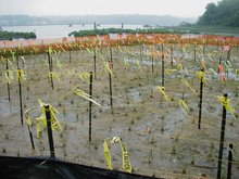
Saltmarsh restoration at Bar Beach Lagoon, Long Island Sound, New York. These efforts are the result of a comprehensive settlement for cleanup and natural resource damages at a Superfund site and conducted through the collaborative efforts of many agencies, potentially responsible parties, and community partners. Low marsh and high marsh species were planted by volunteers in an east coast saltmarsh following removing of fill (e.g, peagravel, concrete, asphalt) and phragmites.
Occasionally, fuels or toxic chemicals are released into the environment through accidental spills or as a result of historic waste disposal practices. Government agencies and responsible parties work together to stop ongoing releases and mitigate the effects through cleanup activities. However, these releases also have adverse effects on natural resources. The Comprehensive Environmental Response, Compensation, and Liability Act of 1980 (CERCLA or Superfund) and Oil Pollution Act provide legal frameworks that assure risks to public health, welfare, and the environment are addressed, and that the public is compensated for losses of natural resources.
As a federal trustee for coastal and marine natural resources, NOAA works with lead cleanup agencies, co-trustees, responsible parties, and the public to address natural resource injuries caused by the release of oil and hazardous substances. Under CERCLA, trustees can release potentially responsible parties from natural resource damages liability if appropriate measures are taken to protect and restore injured natural resources.
The process of resolving natural resource liability and achieving protection of natural resources has evolved over the years to a more cooperative and integrated approach in most cases. Cooperation with the responsible parties and integration of trustees into the site characterization, risk assessment, and cleanup and restoration planning process ensures that natural resources are efficiently and cost effectively protected from future harm, recovery is accelerated, and coastal habitats are restored for the benefit of coastal communities.
Early Evolution of the Damage Assessment Process
Early Natural Resource Damage Assessment (NRDA) efforts tended to be lengthy, costly, and antagonistic as parties on all sides struggled to understand how to best evaluate and scale injury to resources and how to determine appropriate compensation for the injury. Following the Department of the Interior’s CERCLA NRDA regulations (1986), trustees sought to estimate the monetary value of lost and injured natural resources and resource services. Trustees would then seek these losses from responsible parties. These damages were used to fund restoration projects or other activities intended to benefit the affected resources or public.
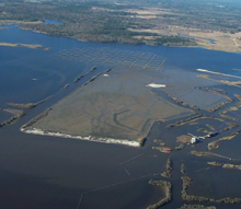
Aerial oblique photograph (December 2003) of the 80-acre Bessie Heights/Bailey National Priorities List salt marsh restoration project. The terrace field in the northwest corner was used during hydraulic placement of dredged material to drop total suspended solids to permit levels.
The parties worked side-by-side, but not cooperatively. In fact, redundant data were often collected to assure that each side had information to support their position. The adversarial nature of this approach and its reliance on cash as the measure of settlement, as well as numerous other inefficiencies, led some parties to conclude that it might be better to fight than cooperate. Litigation and lack of cooperation can create high costs, drag out the NRDA and cleanup processes, and delay the planning and implementation of restoration projects.
During early Superfund site cleanup activities in the 1980s, remedial investigations (including ecological risk assessments and development of protective remedies) were often not coordinated with damage assessment activities. This lack of coordination can create duplication of effort since risk assessment conducted for cleanup decision making and injury assessment conducted for NRDA often evaluate the same resources.
Increasing Coordination
Beginning in 1985, to assure protection of our trust resources, NOAA co-located environmental scientists as part of the Coastal Resource Coordination program in response-agency offices around the coastal United States. This created the opportunity to practically integrate response and restoration planning, simultaneously resolving cleanup and liability for injury to natural resources. Additionally, by working with all parties during the cleanup process, it was possible for potentially responsible parties to incorporate restoration features into remediation, such as designing a contaminated sediment cap with its tidal elevation suitable for establishing marsh or a functional mud flat habitat. Even if this degree of integration of remedy and restoration was not possible, a potentially responsible party could plan to coordinate these activities to minimize mobilization and other costs.
Coordination by lead cleanup agencies and co-trustees during the remedial process resulted in negotiated global settlements of all CERCLA cleanup and NRDA liability at many small sites around the country. These sites frequently included additional measures to conduct restoration projects coordinated with protective remediation to compensate for injury and achieve natural resource recovery more quickly. Larger, more complex sites were referred to another NOAA program to conduct more formal damage assessments and prepare for possible litigation.
Taking a Cooperative Approach
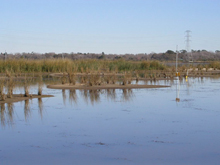
These little islands are a "proof of concept" test of an innovative construction technique that deposits a heavy mud/sand slurry to maximize a created marsh edge and reduce material handling and shaping costs. Click image for larger view and full caption.
As a result of lessons learned from years of working within the framework of the CERCLA NRDA regulations, NOAA developed regulations for the Oil Pollution Act (OPA) focused on restoration planning, where trustees are encouraged to invite potentially responsible parties to participate very early following a discharge of oil. Under the CERCLA NRDA regulations, NOAA is required to notify potentially responsible parties and invite them to participate in the assessment. Under OPA regulations, the emphasis was shifted away from calculating monetary damages; now, trustees and potentially responsible parties cooperatively determine the type and size of restoration actions needed to compensate for injuries to natural resources and services to form the basis of settlements.
The OPA regulations resulted in a number of streamlined and efficient settlements for oil spills, where restoration was obtained quickly and cooperatively. Focusing on restoration and encouraging active participation of potentially responsible parties in the assessment process has proven to significantly improve the NRDA process for oil spills, making it more efficient time- and money-wise. Trustees and potentially responsible parties began to use the OPA NRDA restoration-focused assessment paradigm for many CERCLA sites, including large complex ones.
Lavaca Bay: A Case Study
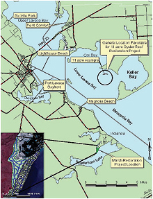
The Lavaca Bay site was an active bauxite refinery and aluminum smelter located on the Texas coast, halfway between Houston and Corpus Christi. Mercury was released from plant operations and wastewater discharged to Lavaca Bay. As a result of cooperative assessment by government agencies and industry and universal settlement for Superfund liability, Alcoa, Inc., created over 11 acres of oyster reef and 70 acres of salt marsh, preserved 730 acres of habitat at the Aransas National Wildlife Refuge, and built several lighted fishing piers currently in use.
Beginning in 1993, NOAA led a successful effort to integrate response and restoration activities at a large mercury Superfund site in Texas. The efforts at Lavaca Bay applied a cooperative approach based on success of previous integrated efforts at smaller sites and OPA regulations. NOAA was in "on the ground floor" during the response and was able to assure that the cleanup would be adequate to protect resources held in trust for the public.
Over time, activities of the teams at this site, composed of response representatives, potentially responsible parties, and trustee representatives, evolved from completely adversarial interactions to cooperative investigations. The old "throw the report over the transom" approach that had prevailed in the old Superfund process relied on formal exchange of large draft reports and many rounds of comment, response, and redraft. The teams learned that working more interactively through work plan development, field and lab work, and data interpretation was a better way to reach agreements.
The team simultaneously planned the cleanup and restoration actions that made a universal settlement possible. The restoration projects that were agreed upon are now completed. Fish, crabs, shrimp, birds, clean water, flood protection—all of the natural resources and resource services that a functioning restored habitat provides—are beginning to flow. Monitoring to assure that the restoration projects remain "successful" is also ongoing. The agreements reached at Lavaca Bay are far more durable and the results achieved far better than those reached using the old approach.
Streamlined Tools
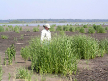
Texas Parks and Wildlife Department biologist Mike Rezsutek examines a clump of “volunteer” Spartina alterniflora that has colonized the dredged material at Bessie Heights.
As the process of cooperative assessment evolved, NOAA developed tools to streamline and improve the scaling process for injury and restoration. For example, Habitat Equivalency Analysis uses economic and ecological principles to evaluate service losses associated with contaminant concentrations causing injury to natural resources at a site. These evaluations are balanced against the services gained from implementing restoration projects. The tool creates a framework to clarify and document assumptions that must be made in scaling injury and restoration.
Most recently, NOAA’s Damage Assessment, Remediation, and Response Program has expanded to integrate staff working on remedial and damage assessment activities into one group. This cooperative and integrated approach is characterized by early integration of remediation and restoration; streamlined data assembly to support both remedial and restoration planning; development of protective cleanup strategies to minimize residual injury and promote coastal recovery; injury assessment, restoration planning, and scaling; negotiated release of natural resource damage liability and restoration-based settlements; and monitoring of restored habitats.
The process of scaling injuries and identifying appropriate restoration is tailored to the conditions and/or circumstances at individual sites, including such factors as the degree of contamination, the type and mixture of contaminants at the site, expected severity of toxicity and type of effects, the sensitivity of the natural resources present, and the willingness and ability of responsible parties and trustees to be flexible in their approach to restoration.
Working with our tribal, state, federal, and responsible industry partners, NOAA has completed reasonable assessments that get the most use possible out of existing data and employ "conservative" interpretation (in favor of the public’s interest). Over the years, a lot has been learned about getting to restoration "on the ground," a goal that responsible parties and trustees can mutually agree upon as the preferred outcome of a natural resource damage assessment.
What Have We Accomplished?
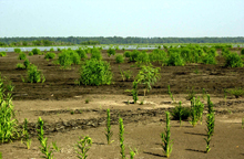
Luxuriant Spartina alterniflora growth on the rich dredged material at the 80-acre Bessie Heights/Bailey National Priority List salt marsh restoration project.
NOAA’s cooperative settlement approach is being used successfully at dozens of coastal sites nationwide. The approach allows parties to settle their natural resource damage liability cost effectively and to restore habitat as good citizens. The cooperating party saves time and money; the public receives compensation earlier for its losses; and fish and wildlife and coastal areas are protected and restored more quickly.
Thus far, the cooperative integrated remediation and restoration approach has accelerated the recovery of natural resources and restored/conserved over 4,000 acres of coastal habitat.
Contributed by Ron Gouguet, NOAA’s National Ocean Service
