Ongoing Restoration of Lavaca Bay, Texas
A Real-World Example: Texas Style
The Lavaca Bay Superfund Site, on Point Comfort, Texas, is an excellent example of the successful outcomes that can be achieved when a cooperative, integrated approach is used to address both the cleanup of contaminated areas and to plan the on-the-ground restoration needed to resolve natural resource damages liability.
In Lavaca Bay, Texas, 64 square miles of the estuary were contaminated by chronic mercury releases from several types of past manufacturing processes at Alcoa's Lavaca Bay facility. High levels of mercury released from the facility contaminated sediments and several species of fish and crabs. Eventually, the Texas Department of Health closed a portion of the bay to fishing in 1988.
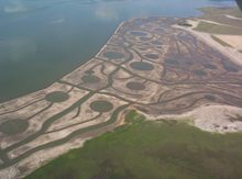
Seventy acres of salt marsh were created as a result of the cooperative Natural Resource Damages settlement with NOAA, co-trustees, and Alcoa, using the latest science from the NOAA Galveston Laboratory. As part of the Aransas National Wildlife Refuge, this new marsh adds to the foraging area of endangered whooping cranes. Click image for larger view.
By integrating a restoration-based damage assessment with the remedial process (environmental clean-up), the natural resource trustees (including NOAA) and the responsible party (Alcoa) were able to avoid litigation over damages to the natural resources. These parties were also able to use a more timely, cost-effective approach to restore Lavaca Bay's natural resources.
Preliminary Studies
In 1992, Alcoa and the natural resource trustees initiated preliminary studies focused on understanding the mercury distribution and associated resources injuries in Lavaca Bay. In 1994, the U.S. Environmental Protection Agency (EPA) placed Lavaca Bay on the National Priorities List and invited NOAA, a trustee agency, to participate in negotiating the terms of a consent order under which Alcoa would conduct a Remedial Investigation/Feasibility Study (RI/FS) for the site.
The EPA and the State of Texas developed a Cooperative Management Agreement defining the governments' approval process for oversight of Alcoa during the RI/FS. The EPA insisted that natural resource trustees, including NOAA, were involved in the RI/FS process.
A Plan for Remediation

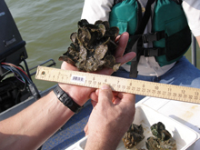
Monitoring for the oyster reef restoration “Alcoa Project” found these five-month-old oysters growing rapidly in the newly created 15-acre oyster reef in middle bay. Click image for larger view.
The trustees, EPA, and Alcoa began working together to resolve the site's problems. The parties soon came to two conclusions: 1) the science required for the remedial investigation was similar to what was required for the damage assessment and 2) the damage assessment should be conducted parallel to the RI/FS, rather than after the remedial process. In response, remedial investigations included thorough ecological risk assessments for protective cleanup decisions and, to the extent possible, trustee data needs. This limited the costs of additional data collection for the assessment.
Assessment of Injuries

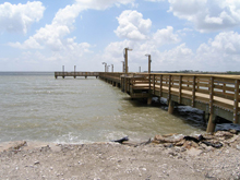
NOAA and our co-trustees, working with Alcoa and the City of Port Lavaca, built a 300-foot lighted fishing pier in the bay front park to restore access to the recreational fisheries. Click image for larger view.
The trustees and Alcoa agreed to assess injuries using the data collected during the RI/FS, rather than spend additional time and money on injury studies. In using this data, the parties also agreed to apply a reasonable worst-case (RWC) approach. The RWC approach yields more conservative, environmentally protective estimates of resource injuries and losses. This approach was used to estimate losses for birds, fish, terrestrial organisms, groundwater, and surface water and to identify acres of injured habitat to restore. Joint Technical Memoranda were developed to document the approach and are serving as roadmaps for future restoration efforts.
A Happy Ending
As a result of this process, over 11 acres of oyster reef and 70 acres of salt marsh have been built, over 700 acres of coastal prairie habitat is recovering from overuse by cattle and is being permanently preserved, and three lighted fishing piers and boat ramps are now in place to restore the fishing opportunities the public lost.
Contributed by Ron Gouguet, NOAA's National Ocean Service
