A History of Environmental Satellite Systems
Operating the country's environmental satellite systems is one of NOAA's major responsibilities. Cloud images collected from these satellites are seen daily on television weather forecasts and data collected are also used for applications such as climate research and prediction, volcanic eruption monitoring, forest fire detection, and search and rescue operations. NOAA's National Environmental Satellite, Data, and Information Service operates the satellites and manages the processing, distribution, and archiving of satellite data to ensure that these data are available to researchers, planners, weather forecasters, the general public, and all others who use valuable satellite data.
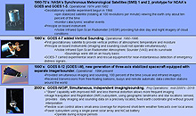
Historical overview of NOAA GOES satellites. Click image for larger view.
NOAA’s satellites have stood watch over the U.S. and other nations for over four decades. The agency’s satellite operations grew out of National Aeronautics and Space Administration (NASA) and Department of Defense early space programs and the desire to study our Earth from a vantage point high in the sky. Originally built and operated primarily to support the needs of the National Weather Service's global forecasting responsibility (the polar-orbiting satellite program) and their weather warning service (the geostationary satellite program), today data are used not only for weather forecasting, but also for a range of applications, from studying oceans and coastal regions to monitoring of the ozone hole over the South Pole and the space environment.
NOAA's operational environmental satellite system is a complement of polar-orbiting environmental satellites (POES) and geostationary operational environmental satellites (GOES). Both types of satellites are necessary for a complete global weather network.
While NOAA satellite functions have evolved over the years to provide data used in ocean, coastal, and agricultural research, the following text discusses the history and uses of NOAA satellites for weather research and forecasting.
The History of Polar Satellites
Polar satellites are spacecraft that follow a nearly polar orbit of the Earth. A satellite in a polar orbit passes above (or nearly above) both the North and South Poles on each revolution around Earth. Because of this orbit, these satellites are able to collect global data on a daily basis for a variety of land, ocean, and atmospheric applications.
Weather satellites date back to 1958 when the Department of Defense (DoD) began developing spacecraft specifically for meteorological purposes. This spacecraft was named TIROS, short for Television Infrared Observation Satellite. In 1959, the TIROS program was transferred to the National Aeronautics and Space Administration (NASA).
Television Infrared Observation Satellites (TIROS)
One of the most exciting moments in NOAA history was April 1, 1960, when the first weather satellite was launched from Cape Canaveral, Florida. The polar-orbiting TIROS-1 provided forecasters with the first view of cloud patterns as they developed and moved across the continent. TIROS spacecraft were developed by NASA and managed by NOAA’s predecessor organization, the Environmental Science Services Administration (ESSA).
Additional polar-orbiting TIROS research satellites were launched over the next several years, testing new optical lenses and transmission techniques. For example, TIROS-8 tested an Automatic Picture Transmission system that directly relayed imagery to stations on the ground. The TIROS-9 satellite, launched in 1965, gave the first complete daily coverage of the entire sun-illuminated portion of the Earth.
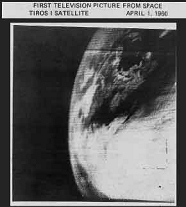
First television image from space, taken by TIROS-1 in 1960.
On July 1, 1965, TIROS-10, the first fully operational meteorological satellite, was launched. Also in 1965, the Nimbus-1 satellite carried an infrared (IR) sensor, capturing the first nighttime images from space. TIROS-10 and Nimbus-1 proved the feasibility of an operational system of weather-watching satellites with many instrument types and orbital paths around the Earth. These early systems led to the development of more sophisticated meteorological observation satellites.
Environmental Science Services Administration (ESSA) Satellites
The world’s first operational weather satellite system was achieved in 1966, with the launch of ESSA-1 and ESSA-2. The ESSA program, initiated as an extension of and a complement to the TIROS program, provided cloud-cover photography to the American National Meteorological Center. Over a period of almost four years, ESSA satellites transmitted thousands of images back to Earth, enabling predictions of weather patterns, including hurricanes.
Improved TIROS Operational System (ITOS)

Samples of initial polar imaging. Click image for larger view.
By 1972, TIROS research and development was completed, the ESSA series (which included nine satellites) were retired, and the first Improved TIROS Operational System (ITOS) was launched. NOAA's ITOS operations vastly improved ESSA operations. ITOS provided day and night viewing of Earth cloud coverage, simultaneous broadcasts of data, and data storage for later playback to a station on the ground. ITOS also measured snow, ice, and sea surfaces and gathered temperature and moisture profiles daily. On later satellites, additional instruments provided global daytime and nighttime real-time cloud cover data.
In 1973, NOAA was directed to use the DoD Air Force Defense Meteorological Satellite Program (DMSP) Block 5D development spacecraft design for the next generation polar-orbiting series. To achieve daily, day and night global atmospheric coverage, NOAA used two satellites flying at the same time. In 1978, the first of these polar satellites, TIROS-N, was successfully launched.
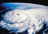
Polar satellite image of storm formation
To date, 42 polar weather/environmental satellites have been launched: 10 TIROS (1960-65), nine ESSA (1966-69), eight ITOS (1970-76) (two launch failures), and 15 TIROS-N/NOAA (1978 to present) (one launch failure).
The History of Geostationary Satellites
Geostationary satellites provide the kind of continuous monitoring necessary for intensive data analysis. They circle the Earth in a geosynchronous orbit, which means they orbit the equator at the same speed as the Earth's rotation—or make one orbit per day. Since the Earth rotates once a day, and the satellites move at the same speed as the Earth, the satellites “hover” continuously over one position on the Earth’s surface, collecting data specific to a single region or area.
The evolution of geostationary satellites began in the early 1970s, when, as a follow-up to successful experimental communications satellites of the early 1960s, NASA began the Applications Technology Satellite (ATS) experimental program. The purpose of this program was to demonstrate the use of satellites for activities such as weather observation and investigation of the space environment.
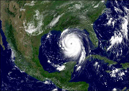
GOES satellite view of Hurricane Katrina, 2005
ATS orbited above the equator at a “medium” altitude of 22,235 miles. At lower altitudes, satellites orbit the Earth more than once per day and thus do not hover over the same area of the Earth's surface all the time. ATS demonstrated the value of a medium altitude orbit for maintaining a continuous watch over Western Hemisphere weather.
The success of ATS for weather research led NASA to develop a satellite specifically designed to make atmospheric observations in a geostationary orbit. NOAA began collaborating with NASA in this endeavor and NOAA’s Geostationary Operational Environmental Satellite (GOES) program was started during this cooperative period. In 1974 and 1975, NASA designed, built, and launched the first two geosynchronous weather satellites (Synchronous Meteorological Satellites [SMS-1] and SMS-2). These satellites were the development models for the early GOES. GOES-1 was launched in October 1975.
GOES-4, launched in 1980, continuously provided temperature and moisture data and allowed “frame-to-frame” cloud movement observation for wind speed, direction, and a better understanding of atmospheric circulation patterns.

GOES Water channel, IR channel, and Visible channel imaging showing areas of dense cloud formations. Click image for larger view.
GOES spacecraft operate as a two-satellite system, or constellation, above the equator. These satellites observe 60 percent of the Earth, measuring the Earth’s atmosphere, surface, cloud cover, and the solar and space environments. The eastern GOES satellite is positioned to provide the best view from near Western Africa to beyond the central part of the United States, and the western satellite provides coverage from the center of the United States to beyond Hawaii. Together, these satellites provide NOAA with a complete, continuous view of the United States.
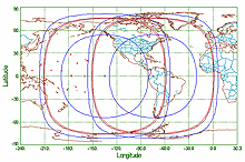
Two Geostationary satellite coverage areas. Click image for larger view.
The GOES system has continued to improve with new technological innovations and sensors. To date there have been 16 geostationary weather/environmental satellite launches: 2 SMS (1974-75), 14 GOES (1975-present) (1 launch failure).
Conclusion
The 1960s and early 1970s was a period of phenomenal discovery and development in remote sensing and data interpretation, due in large part to the collaborative relationships between NASA, DoD, and NOAA. NOAA inherited NASA’s and DoD’s environmental satellite technology development, while NASA and DoD received NOAA’s insight into daily satellite operations, data applications, timely data processing and distribution, and user community services.
Through partnerships with other federal organizations and international earth observation committees, the NOAA satellite evolution will continue to advance space-based observations, to expand beyond meteorology and help us understand all aspects of Earth and space environments. Both polar and geostationary satellite applications deliver a broad range of information that, when used with other data, benefit everything from agriculture and forestry services for yield predictions and harvest to helping emergency managers monitor hazards or provide disaster assessments in the wake of natural disasters such as hurricanes.
