Tornado Detection and Warnings
- A Life Saving Discovery
- Doppler Radar
- Detecting Tornadoes
- A Nationwide Network
- Dramatically Improved Warnings
- Other Uses
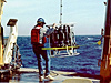
A Life Saving Discovery

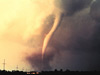
The 1973 Union City, Oklahoma tornado, shown here, was the first tornado captured by the National Severe Storms Laboratory Doppler radar and chase personnel. The tornado here is in its early stage of formation. Click image for larger view.
On May 24, 1973, a violent tornado produced fatalities and extensive damage as it passed through the heart of the small farming community of Union City, Oklahoma, just west of Oklahoma City. The newly commissioned Doppler radar at NOAA’s National Severe Storms Laboratory observed this tornado, and researchers from the laboratory’s Tornado Intercept Project photographed the tornado’s life cycle. The radar, coupled with the photographic evidence of the tornado’s development, revealed previously unknown information about motion inside thunderstorms with a persistent rotating updraft (known as supercell storms). This discovery led to dramatic improvements in accuracy and lead time in forecasting severe storms nationwide, and along with them, the ability to save lives and prevent serious storm-related injuries.
Doppler Radar

Doppler radar enables forecasters to create different types of images that allow them to track and forecast severe weather in real time. This base reflectivity image for a region along the Gulf of Mexico indicates that the most intense precipitation is falling in the small red areas within the larger yellow areas. Click image for larger view.
Doppler radar uses radio waves to create pictures showing the location and intensity of precipitation. Doppler radar allowed scientists to measure motion inside storms for the very first time, providing valuable clues into the development of severe weather. Using this radar, scientists also discovered that when a tornado begins to form, its winds blow raindrops in a way that appears as a distinguishing pattern or signature on the radar screen.
Detecting Tornadoes with Doppler Radar
Researchers discovered that the Union City tornado produced a unique Doppler radar velocity measurement called a tornadic vortex signature. They found that this signature formed within the storm’s rotating updraft (also known as a mesocyclone). Initially, the signature appeared at mid-altitudes in the updraft over 20 minutes before tornado touchdown—well before the tornado appeared. As the storm grew and intensified, the signature lengthened, both upward toward storm’s top and downward toward the ground. The radar signature reached the ground at the same time as the tornado. It was strongest and extended throughout most of the storm’s depth when the tornado was strongest and disappeared as the tornado died.
The knowledge gained from the Doppler radar measurements in the Union City storm, and in later supercell storms, led meteorologists to understand that the Doppler velocity signature of a mesocyclone is a necessary (but not the only) precursor for a tornado to form in supercell storms. When the Doppler velocity measurements reveal a developing tornadic vortex signature within a mesocyclone, forecasters are more confident that a tornado soon will appear.
A Nationwide Network of Doppler Radar

NOAA operates most of the 158 stations in the nation's Doppler radar network. Click image for larger view.
The National Weather Service was so impressed by the warning potential of these Doppler velocity signatures, that it joined with the Federal Aviation Administration, the Air Force’s Air Weather Service , and National Severe Storms Laboratory in the Joint Doppler Operational Project, 1977-1979, to test the radar's ability to improve tornado warnings. The test was so successful that these organizations immediately set up an office to acquire and establish a national network of Doppler weather radars. The program was called NEXRAD (NEXt generation weather RADar), and the radars were called WSR–88Ds (Weather Surveillance Radar–1988 Doppler).
Between 1990 and 1997, the U.S. government acquired and installed a network of 158 Doppler radars, most of which are operated by NOAA’s National Weather Service. The NEXRAD network enhanced public safety awareness and scientific research by establishing reliable and accurate real-time data across the entire nation for the first time.
Dramatically Improved Tornado Warnings

Domes like this protect Doppler radar equipment. Click image for larger view.
NEXRAD is a primary factor in dramatic improvements in the accuracy and lead time of tornado warnings in the 1990s. Tornado warning lead time increased from less than five minutes prior to NEXRAD to 13 minutes; tornado warning accuracy increased from 40 percent to 75 percent; and, remarkably, flash flood warning lead time increased from 14 minutes to 54 minutes. A 2005 study concluded that following NEXRAD installation, improved tornado warnings resulted in 45 percent fewer fatalities and 40 percent fewer injuries annually. NEXRAD has become the primary data acquisition cornerstone of the National Weather Service’s severe weather warning program.
Other Uses of Doppler Weather Radar
NEXRAD data are also the foundation of a number of other products and services. High-resolution data are distributed throughout government agencies, academia and the private sector both in real-time and from the archives of NOAA’s National Climatic Data Center. The Federal Aviation Administration displays real-time NEXRAD data on air traffic controller screens; the data are vital to managing the safety and efficiency of the nation’s airspace. Private businesses now market displays of NEXRAD data to TV stations and produce other products for a wide variety of commercial clients. Private sector innovations enabled displays of real-time NEXRAD data in cockpits of all categories of aircraft. These markets have grown in large part on the availability of real-time radar data. Nationwide estimates of precipitation based on NEXRAD algorithms improve management of fresh water resources, agriculture and forestry, and snow removal priorities. With radar products readily available in media outlets and on the Internet, citizens can make improved travel, business, leisure and resource protection decisions.
NEXRAD has led to better understanding of atmospheric processes, saved lives and property, and contributed to our national economy. It is a remarkable achievement and a prime example and of NOAA’s science, engineering, and dedication to public service coming together for the betterment of our nation.