Thirty Years of Hydrographic Automation
NOAA's Office of Coast Survey conducts hydrographic surveys to measure the depth and bottom configuration of water bodies, to produce the nation's nautical charts and ensure safe navigation of U.S. waters. The surveys also identify sea floor materials, dredging areas, cables, pipelines, wrecks and obstructions, and fish habitats. They support a variety of activities such as port and harbor maintenance, coastal engineering, coastal zone management, and offshore resource development.
- Introduction
- Pre- Automation Era
- Hydroplot Era: 1967 to 1987
- HDAPS Era: 1987 to 1997
- Modern Era: 1997 to present
- Conclusion
It is 1977. Jimmy Buffet's "Margaritaville" is playing in the background as NOAA Corps junior officers and survey technicians gather in the NOAA ship's plot room. Although it has already been a long day of collecting hydrographic survey data, the officers and technicians know that the day is far from over. They will be up all night editing and processing the collected data, so that it can be translated into the format needed to create nautical charts.
Hydrography is the science which deals with the measurement and description of the physical features of bodies of water and surrounding land areas. Special emphasis is usually placed on the elements that affect safe navigation and the publication of such information in a suitable form for use in navigation (e.g., nautical charts).
NOAA and its predecessor agencies have been collecting hydrographic data for nearly 200 years. Throughout this time, hydrographers have always been interested in three parameters: time, position, and depth. One thing that has changed over time is how hydrographers collect this information. This article looks at advances in NOAA hydrographic survey automation over the last 30 years.
The Pre-Automation Era: A Brief History of Hydrographic Surveying
For centuries, hydrographers used instruments such as chronometers, sextant fixes, and lead lines to determine time, position, and depth. Hydrographers collected depth data by dropping a hand-held lead line over the side of a vessel. Position was determined by three-point sextant fixes to mapped reference points. The time, sextant angles, and depth were recorded by hand. This process was labor-intensive and time-consuming, and while the data were accurate, the soundings were limited in number and did not cover the entire ocean floor in an area.
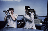
Here, two hydrographers shoot a sextant fix for hydrographic surveying. Click image for larger view.
Processing this data involved manually correcting the depth for tide and plotting the reduced depth and position on a boat sheet with a three-arm protractor to produce a piece of paper showing positions and depths of survey observations. This "hydrographic smooth sheet" was the foundation for the nautical chart.
The mid-20th century was marked by advancements in electronic positioning and depth finding instrumentation. In the 1930s, echo sounders, which used sound waves to determine depth, were introduced. Beginning in the 1950s, electronic positioning systems allowed surveyors to simultaneously record two ranges from known points ashore. While these advances were significant, data were still recorded manually and the final smooth sheet was an analog product.
In the early and mid-1960s, semi-automated techniques, like data logging to paper punch tape, were developed. These semi-automated systems were the preamble to the digital age.
The Hydroplot Era: 1967 to 1987
The Hydroplot system was the first fully automated hydrographic data acquisition and processing system used by NOAA field units. It was declared operational after being installed aboard the hydrographic survey vessel Whiting in 1967.
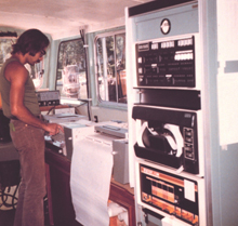
A survey technician aboard a NOAA survey vessel uses the Hydroplot system, which recorded hydrographic data on paper punch tape. Click image for larger view.
With Hydroplot, an echo sounder was used to determine depth and the Hydroplot Controller, an interface between sensors and a computer, coordinated data acquisition. Two electronic ranges from positioning systems created X-Y coordinates, and the computer was programmed so a straight line could be steered by following a steering needle on a "heads up" meter.
One of the most impressive components in the system was a DP-3 Houston Roll plotter. During data acquisition, the plotter pen moved every second as the electronic positioning system was updated. The pen's position on the mylar boat sheet corresponded to the vessel's true position. At every "mark," the time, depth, and electronic ranges were recorded on paper punch tape at predetermined intervals—often 20 or 30 seconds. Simultaneously, the plotter pen printed out a predicted tide-corrected depth.
When it all worked, the Hydroplot technology was spectacular for its time. However, even with these advances, after the end of a long day of surveying, hydrographers still had to look forward to a long evening of editing collected data.
Echo sounding records needed to be scanned to ensure that representative shoal depths appeared on the final survey. Because waves tossed the vessel around, the echo sounder depths selected during data acquisition often required editing. Since the system only recorded data every 20 or 30 seconds, underwater features "spikes" that appeared on the echo sounding record between marks had to be inserted. Very often, the positioning system became erratic and erroneous position readings ("flyers") were recorded.
The HDAPS Era: 1987 to 1997
While the Hydroplot system was state of the art in the 1970s, it quickly grew antiquated in the 1980s because of the use of paper punch tape, an inadequate data sampling rate, and the introduction of more powerful computer workstations.
In the early and mid-1980s, NOAA undertook a project to create the next generation data acquisition and processing system, called SDS III. In 1987, the project was terminated because of schedule and technical issues. NOAA was left in an embarrassing situation: With personal computers (PCs) now commonplace, NOAA hydrographic survey ships were still collecting data with paper punch tape.
As the SDS III project was in its final days, a small NOAA team began developing a system called the Hydrographic Data Acquisition and Processing System (HDAPS). Two of NOAA's ships, Rude and Heck, were equipped with side scan sonars and HDAPS was designed to be a specialized system to acquire and process this side scan sonar data.
HDAPS allowed multiple lines of position to be used in computing a least squares position on the fly. A least squares position is statistically the most likely position that can be determined based on redundant lines of position. Unlike the unique positions that were determined from two lines of position, least squares positions offered higher levels of accuracy for surveying. HDAPS also factored in the ship's gyro compass heading and acceleration constraints into the position solution, dramatically reducing the problem of position "flyers." Five high-frequency and five low-frequency depths could be recorded each second. HDAPS also used a Hippy Heave Sensor, one of the first production instruments that recorded vessel heave, pitch, and roll. The application of heave correctors to echo sounding readings was particularly important as they reduced the need to manually scan analog records to correct for the up and down motion (heave) of the ship. Initially, data were recorded each second on magnetic tape.
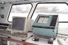
The Hydrographic Data Acquisition and Processing System was used by NOAA's surveying ships and craft to acquire and process hydrographic survey data.
Like the Hydroplot system, the HDAPS data acquisition system featured a computer, an intelligent interface, a steering needle, and a plotter. The "brain" of the system was the computer. Once a second, the computer "interrogated" the intelligent interface, which buffered inputs from all sensors, and recorded pertinent sensor information. The plotter created a swath plot that corresponded to the area that was being covered by side scan sonar. In addition, HDAPS computed positions of side scan sonar contacts in near real time.
After working out some software and hardware bugs on the systems installed on Rude and Heck, it became apparent that HDAPS would be useful for conducting basic hydrographic surveys. HDAPS was soon installed on the other NOAA hydrographic survey ships and a more portable PC-based version of the system was used by shore-based field parties.
HDAPS served NOAA's hydrographic fleet well for about 10 years, until other technologies caught up with, and surpassed, the system. During the 1990s, differential global positioning system (DGPS) technology became the standard in hydrographic positioning. With DGPS, multiple lines of position from shore-based transmitting stations were no longer required. DGPS gave survey vessels (and every mariner) instant, all-weather, high-accuracy positioning. Around the same time, shallow water multibeam sonar systems were becoming operational. Unlike previous survey systems, multibeam systems allowed full coverage of the ocean floor.
Unable to accommodate the technological advances of the 1990s, HDAPS was rendered obsolete.
The Modern Era: 1997 to the Present
Throughout the 1990s, computer processing power and digital storage capacities advanced to a point where huge volumes of multibeam sonar depth data could be recorded and retrieved efficiently. Today, NOAA field units use different combinations of "off-the-shelf" hardware and software to collect and process hydrographic data.
Many NOAA ships and launches today are equipped with Reson SeaBat Multibeam echo sounders. These echo sounders collect 4,000 soundings per second for a swath up to 600 meters in width, allowing dense coverage of the ocean floor. The system can survey a swath over seven times the width of the under-keel depth. Also, multibeam sonar data are recorded at a rate of about 0.5 gigabytes per hour, meaning large amounts of data are collected in a relatively short period of time.
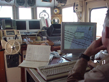
This picture shows a recent configuration of hydrographic instrumentation aboard the NOAA ship Rude. The system features DGPS technology, digital side scan sonar, and multibeam sonar. Click image for larger view.
Some NOAA ships and launches today are equipped with a Klein 5000 side scan sonar system. Many of the first generation side scan systems lost image resolution when survey vessel speeds exceeded five knots. Today's side scan sonar systems can collect data at vessel speeds up to 10 knots. All data are recorded digitally at rates of about 1.25 gigabytes per hour.
The combination of side scan and multibeam sonar allow NOAA hydrographers to achieve 100 percent bottom coverage on virtually all surveys. This translates into more comprehensive nautical charts.
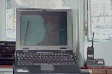
The Electronic Chart System is a system which electronically integrates accurate NOAA electronic navigational chart data with GPS-derived ship location on a PC-based platform. This provides a highly accurate marine navigation system.
The heart of today's NOAA hydrographic processing systems is a suite of multibeam and side scan sonar image processing tools. The tools enable hydrographers to sort through terabytes of multibeam and side scan sonar data to precisely define and portray bottom features that are relevant to nautical charting. Three-dimensional images of the ocean bottom are routinely produced during data processing. One of the many challenges in today's data processing environment involves creating data sets that can easily be used with NOAA electronic navigational charts, or ENCs®.
Conclusion
As new technologies for collecting and processing hydrographic data have become available, the amount of information available to mariners has increased. However, throughout the history of the Coast Survey, the quality of information has never wavered.
After 30 years of hydrographic automation, one truth has become evident: While new technology solves old problems, new and advanced capabilities produce new challenges. In 1977, hydrographers had to grapple with the tediousness of working with paper punch tape and, without having full bottom coverage, they had to produce an inferred picture of the ocean floor. The challenge for hydrographers in 2007 is to discover and portray all of the important underwater features that may be hidden in mountains of data.
There is one important thing that has not changed in 30 years of hydrography: Hydrographers still love to process data to the tune of Jimmy Buffet's "Margaritaville."
Contributed by Nick Perugini, CAPT, NOAA (ret.)
