Using Lead Lines to Collect Hydrographic Data

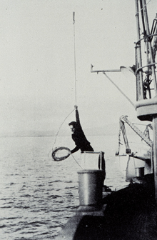
Leadline sounding operations in the 1930s...wind that sucker up and let ’er fly! Click image for larger view.
Early hydrographic surveys involved measuring depths using a hand-held lead line with positions determined by three-point sextant fixes to mapped reference points. Lead lines were ropes, or lines, with graduated depth-markings and a lead weight attached to the end.
To obtain a sounding, a leadsman stationed in a sounding chair would heave the lead weight far enough ahead to give it time to sink to the ocean bottom just before the leadsman was over that point. A right-handed leadsman coiled in his left hand as much line as was needed to obtain a vertical cast. He grasped the line at the toggle with his right hand and swung the lead over his head in a vertical arc for one or two complete circles, to give the lead sufficient momentum. He released the lead at the bottom of one of the swings, so that it is cast ahead in the direction the vessel was moving. As the lead was thrown ahead, the leadsman would feed out the coiled line from his left hand. When the lead struck the water, it began to sink vertically. The leadsman would gather in the slack line as the vessel approached the spot where the lead hit the water. If the proper amount of line was thrown out, the lead will have sunk to the bottom just before the vessel arrived over it. The leadsman would then haul the line taut and raise the lead slightly off the bottom to straighten the line. He would lower the lead until it touched the bottom just as the sounding chair came vertically over the spot. The depth of the water was then read using the markings on the line.

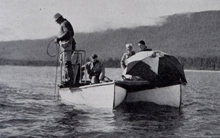
Lead line survey from a catamaran hull in Alaska, 1942. Click image for larger view.
Lead line soundings were usually taken from a slow-moving vessel. Soundings could only be taken in depths where the leadsman could heave the lead far enough ahead of the vessel so that the line could be vertical by the time the vessel “caught up.” This depth limit would vary considerably, depending on the skill of the leadsman and the height of the sounding chair above the water. Under average conditions, the depth limit was approximately 10 fathoms for smaller vessels, and on ships and auxiliary vessels, the limit was approximately 15 fathoms.
Collecting hydrographic data using lead lines was a labor-intensive and time-consuming process. While the soundings may have been accurate, they were limited in number, and thus coverage between the individual soundings was lacking.
