Katrina: Forecasting the Nation's Most Destructive Storm
Hurricane monitoring and forecasting has undergone a remarkable transformation in response to NOAA's investment in ocean and atmospheric research coupled with technological advancements. Emerging from these combined factors has come intricate computer modeling, a vast network of ground- and ocean-based sensors, satellites, and "Hurricane Hunter" aircraft. Amid the current period of heightened hurricane activity, NOAA's role in predicting hurricanes will become increasingly instrumental in aiding the safety of America's burgeoning coastal population and vulnerable infrastructure.
- Introduction
- The Birth of Katrina
- Getting Ready...
- Forecasting Disaster
- The Aftermath
- Conclusion
- Works Consulted
The 2005 Atlantic Hurricane Season was the busiest in recorded history. The Gulf coast region was hit by several large storms, including Hurricane Katrina.
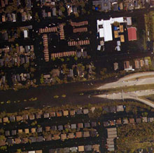
This aerial image of New Orleans, Louisiana, shows where flood waters from Hurricane Katrina consumed homes and cut off roadways. Click image for larger view.
Hurricane Katrina will be forever synonymous with catastrophe. Screaming winds and a raging surge of water towering to heights of a three-story building were among the storm's extreme elements that decimated a vast area of Louisiana, Mississippi, and Alabama. As devastating as Katrina was, the situation actually could have been far worse had it not been for NOAA's accurate forecasts and dedicated team.
The Birth of Katrina
Katrina's fury began innocently enough from a cluster of thunderstorms brewing over the Bahamas. This cluster organized into a tropical depression – the first life stage of a tropical cyclone – on August 23, 2005.
With favorable upper-air wind patterns and the abundance of ocean water above 80° F (26.7° C), winds with the depression soon increased to 40 miles per hour (mph) and the storm was upgraded to this season's 11th tropical storm. Katrina was thus born on August 24 – 13 years, to the date, after Hurricane Andrew devastated South Florida with 165 mph winds.
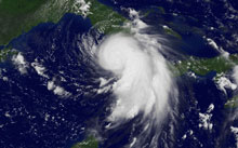
On August 26, 2005, when this satellite image was captured, Hurricane Katrina was upgraded to a Category 2 hurricane. Click image for larger view.
Katrina reached hurricane strength before moving ashore in southeast Florida, near North Miami Beach, with 80 mph sustained winds on August 25. Wind gusts to 87 mph at NOAA's National Hurricane Center then settled to near calm as Katrina's eye passed directly over the very forecasters wary of the storm's impending track toward the warm and energizing water of the Gulf of Mexico.
With the Gulf of Mexico nearly landlocked, hurricanes moving over the Gulf are bound to cross a coastline. And with steering currents tugging Katrina northward, the southern United States, and not Mexico, would have cause for alarm.
Getting Ready...
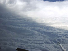
This view of Hurricane Katrina’s eyewall was taken from a NOAA P-3 hurricane hunter turboprop aircraft on August 28, 2005. The serene view belies the destructive power of the Category 5 storm. Click image for larger view.
While Katrina was still a developing tropical storm over the Bahamas, forecasters at the National Hurricane Center consistently predicted Katrina would turn north toward the upper Gulf Coast. It was during the National Hurricane Center's 11 p.m. advisory on August 26 that Katrina's center was forecasted to strike southeast Louisiana and near New Orleans. That forecast went nearly unchanged for the 56 hours prior to Katrina's ultimate landfall.
On August 28, Katrina reached its peak intensity with top sustained winds of 175 mph - a catastrophic Category 5 on the five-level Saffir-Simpson Hurricane Scale. Katrina's central pressure, inversely correlated to wind speed, plummeted to 902 millibars - the sixth lowest ever recorded in the entire Atlantic Basin.
Amid the increasingly dire hurricane track, forecasters with NOAA's National Weather Service were steadfast in providing critical weather forecasts, while accommodating an influx of media and public inquiries, and conducting essential forecast briefings with federal, state, and local emergency officials.
In bracing for the storm's wrath, NOAA facilities in the central Gulf Coast region were evacuated or activated continuity plans to minimize service interruptions. The National Weather Service office in Slidell, Louisiana, became a refuge for most staff members and their families.

During Hurricane Katrina, Max Mayfield, Director of the National Hurricane Center, led outreach efforts to the public and emergency management communities. Click image for larger view and full caption.
Inside the nerve center of NOAA's National Hurricane Center in Miami, Director Max Mayfield led the extensive outreach to the public and the emergency management community, with support from the Center's hurricane experts and a special team of meteorologists assembled from across NOAA. Mayfield also took the initiative to call the governors of Louisiana and Mississippi and the New Orleans mayor to elevate their awareness of the situation. Once more, NOAA's National Hurricane Center was America's calm, clear, and trusted voice when it mattered most.
Forecasting Disaster
As if foreshadowing the news stories that followed Katrina, the Slidell Weather Forecast Office issued a firm statement in the day leading up the hurricane's landfall. The statement included the following messages:
"Most of the area will be uninhabitable for weeks...at least one half of well constructed homes will have roof and wall failure... Airborne debris will be widespread and may include heavy items such as household appliances and even light vehicles...Persons, pets and livestock exposed to the wind will face certain death if struck. Power outages will last for weeks as most power poles will be down and transformers destroyed. Water shortages will make human suffering incredible by modern standards."
As Katrina was making its final approach to the Gulf Coast, the storm's winds were fortunately on the decline, but remained at a formidable intensity. Such winds were the driving force behind the huge waves in the open sea that became the battering waves which devastated the coast. On the morning of August 29, a buoy operated by NOAA's National Data Buoy Center located 74 miles south of Dauphin Island, Alabama, measured a wave height of 55 feet — this matched the largest wave height ever recorded by a NOAA buoy.
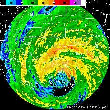
This radar image shows Katrina making landfall. The radar indicates rainfall intensity - the brighter colors (yellows, oranges) indicate heavier rainfall. Click image for larger view and to view as an animation.
Katrina slammed into southeast Louisiana, near Buras, at 6:10 a.m. CDT, on August 29 as a powerful Category 3 hurricane with sustained winds of 125 mph. Landfall was consistently projected to occur in this area by NOAA's National Hurricane Center more than two days prior.
Advances in hurricane research and computer forecast modeling, coupled with continuous data from NOAA aircraft and U.S. Air Force "Hurricane Hunters," aided National Hurricane Center forecasters in producing such accurate track and intensity forecasts with extended lead times. A hurricane watch was issued 44 hours prior to Katrina’s landfall and was upgraded to a hurricane warning 32 hours in advance. High confidence in the forecast allowed NOAA meteorologists to provide this added lead time over what would typically be 36 hours for a watch and 24 hours for a warning.
The Aftermath: Continued Services
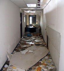
NOAA facilities did not escape the wrath of Hurricane Katrina. In Pascagoula, Mississippi, the NOAA ship Oregon II was rendered unseaworthy after Hurricane Katrina punched a hole into its hull. The nearby NOAA port office, shown here, was also demolished, along with much of the Pascagoula NOAA Fisheries laboratory.
In the aftermath of Katrina, NOAA offices including the National Weather Service Forecast Office and the Lower Mississippi River Forecast Center in Slidell, Louisiana, and the National Data Buoy Center in Stennis Space Center, Mississippi, reacted quickly to the storm’s debilitating blows of structural damage and communication loss.
Teams of people and equipment were dispatched to the disaster area to maintain weather services, support rescue and recovery operations, and ensure the safety of personnel. Several Weather Forecast Offices provided backup assistance to neighboring offices lacking adequate communications. And in support of emergency operations, Weather Forecast Offices offered assistance to emergency response teams as Incident Meteorologists and Remote Area Weather Systems were deployed to the disaster area to provide on-site weather services.
Conclusion
Katrina was not only a storm that NOAA forecasted, but also experienced first hand. Among the devastation were the homes and neighborhoods of the very men and women who were instrumental in protecting countless lives and who remained steadfast in their mission to provide critical weather services while facing the daunting clean up after their own personal disaster.
As with many deadly and destructive storms, Katrina has joined Hugo, Andrew, Charley, Ivan, and many others on the list of "retired" storm names not to be used again. Katrina's slot on the list of storm names, recycled every six years, will be replaced by Katia during the 2011 Atlantic hurricane season. Hopefully, Katia will be nothing like her predecessor...
Works Consulted
Knabb, R.D., Rhome, J.R., & Brown, D.P. (2005). NOAA Hurricane Katrina Tropical Cyclone Report. Retrieved March 28, 2007, from http://www.nhc.noaa.gov/pdf/TCR-AL122005_Katrina.pdf
National Hurricane Center. (2005). NOAA Hurricane Katrina Advisory Archive. Retrieved March 28, 2007, from http://www.nhc.noaa.gov/archive/2005/KATRINA.shtml?
NOAA's National Weather Service. (2005). NOAA Hurricane Katrina Service Assessment. Retrieved March 28, 2007, from http://www.weather.gov/os/assessments/pdfs/Katrina.pdf
