Transforming the Weather Business
NOAA's National Weather Service is the primary source of weather data, forecasts, and warnings for the United States. Television weathercasters and private meteorology companies prepare their forecasts using NOAA information. The National Weather Service is also the sole United States official voice for issuing warnings during life-threatening weather situations.
Have you ever turned on the local morning news to catch the weather forecast for the day? Will you need an umbrella or maybe a jacket? We count on weather forecasts to plan our daily lives. We also rely on weather information to protect us from severe weather such as tornadoes, hurricanes, or thunderstorms—alerting us when to evacuate or seek shelter.
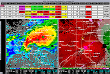
This National Weather Service modern radar display shows the vibrant colors and clear "hook echo" signature associated with a major tornado. This image is the May 3, 1999 F5 tornado that devastated the Oklahoma City area. Click image for larger view.
The weather forecasts or warnings delivered by your local weather forecaster are based on weather information collected and disseminated by NOAA’s National Weather Service. While we may take this information for granted, it was not so long ago that the network and technology for gathering and delivering weather data was not as intricate as what we have today.
This article considers how a 1974 outbreak of one type of severe weather—tornadoes—spurred a transformation in the way that NOAA’s National Weather Service delivers information about all types of weather conditions today.
The 1974 Tornado Outbreak
The April 3-4, 1974, super tornado outbreak was the worst tornado outbreak in U.S. history, with 148 twisters touching down in 13 states. The outbreak lasted over 16 hours and left more than 300 people dead and more than 5,000 injured in a damage path covering more than 2,500 miles.
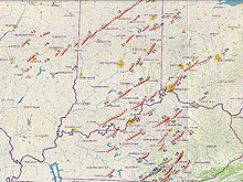
The 1974 super tornado outbreak devastated many areas in Missouri, Illinois, Kentucky, and Ohio. This tornado survey team map of Illinois shows the tracks of the tornadoes the team identified.
The events during those dark days created a new sense of urgency for the nation to integrate modern detection, warning, and communications technology into operations of the National Weather Service. The outbreak also spurred improved cooperation between the National Weather Service, emergency managers, and the electronic media, and led to the first significant expansion of the NOAA Weather Radio network, the National Weather Service’s direct link for providing warnings to the public.
That Was Then: Weather Forecasting in the 1970s
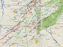
Dozens of tornadoes struck Alabama, Tennessee, Georgia, North Carolina, and other states during the 1974 super tornado outbreak. This tornado survey team map shows the extent of tornado activity in the South.
In the early 1970s, National Weather Service forecasters depended on vintage, World War II-era radar technology to operate a combination of network and local-warning radars to monitor weather systems. The radar units in the national network were obsolete, difficult to service, and large geographic areas were not served by any National Weather Service radar. Some of the radar parts were no longer manufactured.
Forecasters could see only “green blobs” on their radar scopes and had to wait for visual confirmation of a tornado before issuing a tornado warning. The forecasters issued the tornado warnings over antiquated teletypes, which connected to news media wire services such as the Associated Press and United Press International.
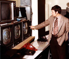
The color display from the National Weather Service "57" radar (shown in photo) was an improvement over the previous generation of black and white radar images.
By 1974, the National Weather Service was a significant presence in communities across the country. A nationwide network of offices staffed by government forecasters provided a wide range of services, including aviation forecasts, agricultural forecasts, and fire weather services. Despite these services, observing and communication technologies had not yet given National Weather Service forecasters the kind of tools they needed to identify tornadoes and communicate warnings early enough for people to take potentially life-saving actions.
“The WSR-57 radar network was the primary tornado warning tool of the era,” said Warren Sunkel, then Meteorologist in Charge of the National Weather Service Meteorological Observatory in Marseilles, Illinois. “It was supplemented by older, less-powerful WSR-1 and WSR-3 radars known as "gap fillers." Volunteer spotters also played a vital role in the tornado warning process. Warnings were typed by hand on a Model 28ASR teletypewriter.”
The Stage is Set…
During the April 3-4, 1974 tornado outbreak hundreds were killed and thousands injured in just 16 hours. While the National Weather Service issued numerous advance warnings to protect the public, the wire services feeding commercial broadcasters could not keep up with the flow of information, leaving the public in the dark and without warnings. “Our forecasters would issue a tornado warning,” said Augulis. “[But] with so much severe weather happening at one time, it didn't take long for the queue to get backed up. We simply couldn't transmit them quickly enough out of our offices. Commercial radio stations had their own problems re-transmitting those warnings and many of them weren’t even connected to the weather wire or involved in the warning process.”
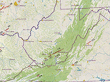
The 1974 tornado outbreak struck West Virginia and Virginia, leaving a trail of devastation.
“I remember that day—there were so many warnings and radar reports on the circuit, that you literally had to be very quick to start your tape to put it into RAWARC (an internal National Weather Service system at the time, used for coordinating warnings),” said Allan Fisher, then meteorological intern at the National Weather Service office in Columbus, Ohio. “The only time to enter your tape was when there was a break in circuit traffic, and that day there was virtually no break in the warnings and radar report on the circuit.”
The Transformation Begins…
A Congressionally directed survey of the 1974 outbreak cited a lack of early warning communications as one of the weaknesses in the warning system. Based on this survey, in January 1975, the White House issued a policy statement designating NOAA Weather Radio as the sole government-operated radio system to provide direct warnings into private homes for both natural disasters and a nuclear attack.
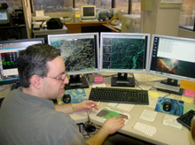
The Advanced Weather Interactive Processing Station developed during the National Weather Service's modernization in the 1990s integrated radar, satellite, and model data, giving the meteorologist immediate access to the information needed to make critical forecast and warning decisions.
This was a critical period in the transformation of the National Weather Service from working with old technology as an independent severe weather forecasting operation into a more sophisticated technological program with stronger ties to emergency officials and the broadcast media. The future held much promise for weather forecasting: new technologies including personal computers, supercomputers, satellite sensors, and Doppler radar were being developed, along with new forecasting techniques including numerical modeling.
Twenty years later, another tornado outbreak prompted renewed interest in improved communications and weather forecasting services. The Palm Sunday 1994 tornado outbreak in the South killed 20 worshippers at the Goshen Church in Piedmont, Alabama. The area was not covered by a NOAA Weather Radio transmitter. The outbreak drew Vice President Al Gore to northern Alabama, where he witnessed the damage first-hand and visited with victims. He announced another ambitious effort to expand the radio network to cover 95 percent of the U.S. population. Today, NOAA Weather Radio transmitters cover 98 percent of the U.S. population.
This Is Now: Modernization Leads to an Improved Weather Service
The Goshen tornado outbreak created new energy behind an ongoing and ambitious $4.5 billion modernization and restructuring effort of the National Weather Service that began in late 1980s. The modernization program took special aim at some of the nation’s most challenging weather, water, and climate events, such as tornadoes, floods, hurricanes, winter storms, and wildfires.
A major new tool in the arsenal of the National Weather Service forecaster’s modernized system was the result of one of the most successful transitions of “research to operations” within NOAA. The National Weather Service and NOAA’s Office of Oceanic and Atmospheric Research developed and deployed a network of NEXRAD (short for NEXt generation RADar) Doppler weather radars that today serve as the backbone of the National Weather Service.
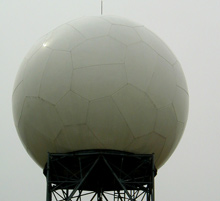
A NEXRAD Doppler radar tower is a common sight around National Weather Service Forecast offices. The radar was the backbone of the National Weather Service modernization that was completed in 2000. Click image for larger view.
Since the Doppler weather radars were installed, the number of tornado casualties has decreased by nearly half. The American Meteorological Society published a study in June 2005 that said that the National Weather Service’s Doppler radars led to a 45 percent reduction in expected fatalities and a 40 percent reduction in expected injuries.
Weather forecasts and warnings improved dramatically thanks to this and other major scientific advances, innovative technologies, improved understanding of the atmospheric sciences, and process improvements at the National Weather Service. The scientific revolutions underway in academic and government research operations of the era led to even more sophisticated data collection and modeling. Results were impressive. Applying new science and technology, the National Weather Service forecasters more than doubled the lead-time for tornado warnings, from six minutes to 13; more than tripled the lead-time for flash flood warnings; cut the track error for hurricane forecasts in half; and nearly doubled the lead-time for winter storm warnings.
The improved capabilities have been demonstrated in numerous events over the last few years, with one particularly noteworthy example on November 11, 2002, when a tornado outbreak destroyed sections of rural Van Wert, Ohio. The National Weather Service broadcast a tornado warning over the network of NOAA Weather Radio stations that now cover the Van Wert area, alerting the local emergency operations center (EOC). The EOC staff heard the warnings and relayed the alert to public buildings, including a movie theater, using a communications system installed just two years before the event.
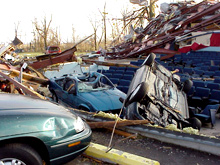
To earn a January 2002 National Weather Service StormReady designation, Van Wert County, Ohio, placed a series of warning alert systems in public locations, including the movie theater (shown in photo) that was destroyed in a November 10-11, 2001 tornado outbreak which killed 35 people. Click image for larger view.
Upon hearing the warning, the theater manager directed about 50 moviegoers into a shelter. Moments later, a tornado ripped through the theater, tearing off the roof and launching several cars onto the seats where children and parents had been watching a movie just moments before.
The National Weather Service, through its improved observation, warning, and communications technology and by working with its partners in public safety, saved countless lives that day—a story that is repeated countless times every year. The community preparedness and integrated warning system worked that day. However, despite this success and many others just like it, the threat from severe weather remains.
Conclusion
The observation, forecast, warning, and communications technology now in place have saved countless lives by preparing and alerting communities of impending disasters. These efforts coupled with new and improved partnerships with emergency managers, the private sector weather companies, and the news media created new public education and dissemination capabilities critical in helping NOAA protect lives and property.
Works Consulted
Johnson, D.L. (2006). Global Perspectives: Protecting Lives, Livelihoods, and Your Way of Life. World Meteorological Day address, published under the Australian Government Bureau of Meteorology seal.
NOAA Magazine. (2006). NOAA's incident meteorologists provide accurate and timely weather information for emergency events. Retrieved September 25, 2006, from: http://www.magazine.noaa.gov/stories/mag189.htm.
Simmons, K. M., Sutter, D. (June 2005). WSR-88D Radar, Tornado Warnings, and Tornado Casualties. Weather and Forecasting 20(3). American Meteorological Society.
