Expanding the Use of Navigational Tools and Products for Coastal Resource Management: Applying Tidal and Geodetic Datums to Wetland Restoration and Emergency Management
NOAA operates and maintains the National Water Level Program and the National Water Level Observation Network. While the tidal datums derived from these programs have historically been used primarily for navigation and shoreline boundary purposes, there are several other beneficial applications and services that water-level and datum information can provide. The Coastal Oceanographic Applications and Services of Tides And Lakes Program focuses on non-navigational uses of this information, such as beneficial uses of dredged material, coastal planning projects, marsh restoration projects, long-term sea-level assessments, storm-surge monitoring, emergency preparedness, and HAZMAT response.
- Introduction
- The Need
- Wetlands Construction
- Large-scale Restoration
- Emergency Management
- Conclusion
- Works Consulted
In the early 1900s, a massive levee system engulfed the “Great Marsh” north of Everett, Washington (known as “Qwuloolt” in the Salish language of the Tulalip Tribe), depriving the 370-acre ecosystem of its natural tidal exchange. The dehydrated wetlands were successfully converted to farmland for nearly a century, until increased urbanization along the creek watersheds led to repeated flooding, making farming unprofitable.
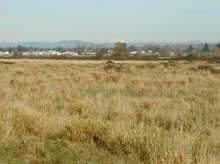
Accurate tidal datums are necessary to restore tidal flow to the dehydrated wetland at Qwuloolt without flooding adjacent communities. Click image for larger view.
In order to restore the once “great” marsh habitat, a plan was developed to breach the levees, flood the property, and let nature take its course. However, there was one significant problem with taking such a simplistic approach—not only would the land be flooded, but so would adjacent existing and planned developments. The Center for Operational Oceanographic Products and Services, within NOAA’s National Ocean Service, was asked to provide water-level information. This information enabled feasibility studies to recommend heightened levee systems around these developments in order to prevent flooding.
This is just one example of the important role that tides play in non-navigational applications everyday. The Coastal Oceanographic Applications and Services of Tides And Lakes (COASTAL) product line was created to address the emerging needs of applying water levels and datum information in non-traditional ways to help save lives, protect property, restore the environment, and maintain the economic vitality of the nation.
COASTAL provides essential decision-support tools to coastal managers concerned with issues such as coastal planning, beneficial use of dredged material, storm-tide monitoring, emergency management, the effects of sea-level rise/subsidence, inundation (flooding), and wetland restoration.
Background: The Need to Restore Wetlands
Wetlands play a crucial role in the productivity of coastal waters, cycling of nutrients, and land stability. They act as nurseries for fish and crustaceans and feeding grounds for birds; store pollutants and nutrients; and serve as buffer zones to flood events and wave action.
These fragile ecosystems have been degraded and destroyed over the centuries at alarming rates. The United States has lost over half of its wetlands since the late 18th century. Coastal wetland loss is caused by a combination of factors, including human activity (such as population growth and coastal development), as well as climate and sea-level changes. With habitat destruction and the failure of natural systems that estuaries support, coastal habitat restoration is becoming a national priority. Thus, it is essential that restoration projects are designed and engineered properly and subsequently monitored. Accurate water-level information and vertical datums (references against which to base height measurements) are critical in ensuring that wetland ecosystems are successfully restored in a sustainable fashion.
Fundament Steps to Wetland Restoration
Wetland restoration projects require several key fundamental processes, including:
1) Determining the tidal characteristics, computing tidal datums, and referencing tidal datums to geodetic datums. Tidal datum elevations are determined relative to the existing and future wetland surfaces by establishing a tide station (typically, for at least one year to capture seasonal effects) with local benchmarks. Tidal datums are then referenced to a geodetic benchmark network using Global Positioning System (GPS) and/or differential leveling techniques, enabling Digital Elevation Models (DEM) to be generated. This baseline information is beneficial in the planning and construction phases of restoration.
2) Analyzing sea-level variation. Long-term sea-level change is assessed to ensure that any sea-level rise is appropriately accounted for in the extended planning phases. Seasonal variations in water level are also examined, as are extreme events.
3) Conducting analyses on the frequency and duration of inundation (flooding). Because wetland vegetation is sensitive to how long and how often it is underwater, frequency and duration of inundation analyses are performed. This information is used to determine where to appropriately plant vegetation.
All of these steps are essential in the engineering design and construction of wetland restoration sites, and rely on accurate water-level and elevation information (which COASTAL can provide), through water-level and GPS observations, and the products derived from those networks.
In order to streamline dissemination of integrated water levels and tidal datums with heights and geodetic datums, a partnership began in 2005 between the Center for Operational Oceanographic Products and Services and the National Geodetic Survey, also within the National Ocean Service, from which a counterpart NGS COASTAL team was formed.
Fort McHenry: Wetlands Construction
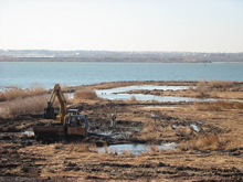
New wetlands being constructed at Fort McHenry. Click image for larger view.
Increased rates in tidal wetland loss in the past two decades have increased the necessity for restoration and creation of wetlands as a form of mitigation, including many areas in the Chesapeake Bay, such as the wetlands adjacent to the Fort McHenry National Historic Monument and Shrine in Baltimore, Maryland. These wetlands were originally constructed in 1982 as mitigation from the construction of the Fort McHenry Interstate-95 tunnels, and were reconstructed as mitigation from the expansion of an adjacent port facility in 2004.
Restoration of the Fort McHenry site was necessary to improve the ecological function of the wetlands. When the wetlands were originally created, there were three small culverts through the wall of riprap encircling the wetlands, which allowed tidal exchange with adjacent harbor waters. However, the culverts were quickly filled with silt, causing the natural salt marsh functionality of the wetlands to be compromised by poor tidal exchange and infiltration of invasive species and trash. Modifications to the site now allow natural tidal flooding, control debris accumulation, and enhance habitat for fauna and flora. This project was a collaborative effort among federal, state, and private organizations.
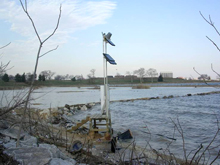
A NOAA tide station in the foreground of Fort McHenry wetlands. In this photo, strong winds from a coastal storm have pushed water over the wetlands. Click image for larger view.
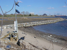
The same NOAA tide station in the foreground of Fort McHenry wetlands, this time two days after the storm, when water has been pushed out. Click image for larger view.
There are many aspects to consider when creating salt marshes within the Chesapeake Bay, including considerations for design and construction. In order to properly design and construct a site, it is essential to know the elevation and be able to grade the Bay floor relative to tidal and geodetic datums and mean sea level. Information on the frequency and duration of inundation is also critical. The physiographic range of the vegetation can be generally related to tidal elevations for use in guidance of where to plant different species. In the case of Fort McHenry, three different species of vegetation were planted.
Providing partners with the tools to plan engineering and planting projects with consideration to tidal and geodetic datums in order to maximize sustainability of the created marsh is one of the primary goals of the COASTAL program.
Blackwater: Large-scale Restoration
Blackwater National Wildlife Refuge in the Chesapeake Bay, a 26,000-acre waterfowl sanctuary located along the Atlantic Flyway, was established as a refuge in 1933.
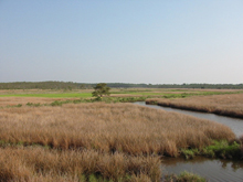
Habitats within Blackwater National Wildlife Refuge include forests, open fields, freshwater impoundments, and estuarine tidal wetlands. Over 250 bird species, including the American bald eagle and peregrine falcon, as well as the endangered Delmarva fox squirrel, can be found at Blackwater for at least a portion of the year. Click image for larger view.
Due to erosion, sea-level rise, saltwater intrusion, and invasive species herbivory, Blackwater National Wildlife Refuge is rapidly losing marsh habitat, with an estimated 8,000 out of 17,000 acres being severely impacted, with an additional loss of 150 – 400 acres per year. The refuge is the hotspot for wetland loss on the East Coast of the United States and is often compared to the rates of wetland loss that coastal Louisiana is experiencing.
Because the refuge is a complex system, the reasons for wetland loss in Blackwater still need to be researched before they can be fully understood. Feasibility studies are underway to understand the processes impacting the Refuge, and to develop a strategy for long-term, large-scale restoration. This research is a collaborative effort among federal, state, and private organizations dealing with restoration, management, and research issues. One of the possibilities being explored for large-scale restoration is to use clean sediment from Baltimore Harbor, as an example of a beneficial use of dredged material at the site.
The establishment of a common reference system based on tide and water-level measurements, GPS surveys, and surface elevation tables (SETS) has occurred. This system will contribute to the development of a DEM that could then be used as a baseline for further engineering studies and to overlay various scenarios.
Emergency Management
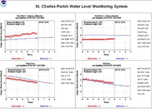
Information collected via the water-level monitoring system in St. Charles Parish allows managers to issue evacuation orders and make decisions that will save lives in an emergency by providing a real-time water-level displays from stations on all sides of the Parish. Click image for larger view.
During coastal storms, water levels can rise to excessive flood levels. Knowing the height of these water levels is critical. Real-time storm tide information is essential for emergency preparedness and evacuation route decision making, especially in the Gulf of Mexico where land subsidence, sea-level rise, hurricanes and other severe storms, and storm surge flooding are commonplace. In partnership with St. Charles Parish, Louisiana, NOAA has established a real-time water-level monitoring system where data are displayed in the local Emergency Operations Center and monitored by emergency managers.
Other regions are also susceptible to coastal hazards. For example, the severe flood damage caused throughout the Chesapeake Bay watershed during Hurricane Isabel spurred a partnership with the Maryland Emergency Management Agency to install additional tide gauges in the Bay to provide continuous coverage of real-time water-level data. Similar to St. Charles Parish, these data are used by emergency managers to make decisions to protect lives and property in the event of an emergency.
Conclusion
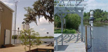
Water-level stations at Bayou LaBranche (left) and Bayou Gauche (right) bracket St. Charles Parish, Louisiana, to create a comprehensive water-level monitoring network. Click image for larger view.
From the traditional tide and water level products, new analyses of high waters, and recent technological advancements, more applications of water levels will continue to emerge. The ultimate goal for NOAA is to provide improved products and services to the coastal manager. By engaging in partnerships, technology transfer, education and outreach; enhancing and developing new products and services; and meeting the requirements for multiple customers’ needs, COASTAL will continue to make great strides in applying tidal and geodetic information in non-traditional ways to help protect life, save property, restore the environment, and maintain the economic vitality of the nation.
Contributed by Kristen Tronvig, NOAA’s National Ocean Service
Works Consulted
Douglas, B.C., M.S. Kearney, & Leatherman, S.P. (2001). Sea Level Rise, History and Consequences. Academic Press. San Diego, CA-USA, pp. 181-220.
NOAA. (2001). Tidal Datums and Their Applications. Special Publication No. CO-OPS 1. National Oceanic and Atmospheric Administration, Silver Spring, MD-USA.
NOAA and Restore America’s Estuaries. (2001). A National Strategy to Restore Coastal and Estuarine Habitat, Executive Summary. National Oceanic and Atmospheric Administration, Washington, DC - USA and Restore America’s Estuaries, Arlington, VA - USA.
