What Is the Global Positioning System?

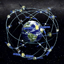
The orbits of GPS satellites are inclined to the Earth’s equator by about 55º. The system is designed to ensure that at least four satellites are visible at least 15° above the horizon at any given time, anywhere in the world. Click image for larger view.
The Global Positioning System (GPS) is a constellation of navigation satellites that orbit the Earth at an altitude of about 12,000 miles (20,000 kilometers). At this altitude, the satellites complete two orbits in a little less than a day. Though originally designed by the U.S. Department of Defense for military applications, the federal government made the system available for civilian uses and lifted security measures designed to restrict accuracy to 10 meters.
The optimal constellation consists of 21 satellites with 3 operational "spares." As of July 2006, there were 29 operational satellites in the constellation.
GPS Signals
GPS satellites transmit two low-power radio signals, called "L1" and "L2." Each GPS signal contains three pieces of information: a pseudorandom code, satellite ephemeris data, and almanac data. The pseudorandom code identifies which satellite is transmitting the signal. The satellite ephemeris data provides information on the location of the satellite at any time. The almanac data provides information on the status of the satellite and the current date and time. For each satellite, the time is maintained by onboard atomic clocks which are crucial for accurate positioning.
Determining Positions
Positions are obtained from GPS by determining distances to the visible satellites. This process is known as "trilateration." The time of the signal transmission at the satellite is compared to the time of reception at the receiver. The difference of these two times tells us how long it took for the signal to travel from the satellite to the receiver. By multiplying the travel time by the speed of light, we can get the range, or distance, to the satellite. Repeat this process on three satellites and you can now determine a two-dimensional position on the Earth (i.e., longitude and latitude). A fourth satellite is needed to determine the third dimension—height. The more satellites that are visible, the more accurate is one’s position.
Although GPS can give us very precise positions, there are still sources of error. These include clock errors, atmospheric delays, not knowing exactly where the satellites are in their orbits, signals reflecting off of objects on the surface of the Earth, and even intentional degradation of the satellite signal.
GPS Devices
Low-end, hand-held GPS receivers cost about $100, receive only the L1 signal, give accuracies on the order of 33 feet (10 meters). On the other end of the spectrum, geodetic-quality receivers cost $10,000 and more, but receive both the L1 and L2 signals and can calculate and correct for many errors associated with GPS, giving positions measured by these devices accuracies on the order of a few centimeters.
