Leveling: An Overview
A surveyor generally needs to know two things about a survey mark: the two-dimensional horizontal location (i.e., latitude and longitude, or plane coordinates) and the third dimension of vertical location (i.e., elevation) of the point.
In a hypothetical situation, if one knows the elevation of point A, and the difference in elevation between point A and point B, then the elevation of point B can be computed. If one then observes the difference between the elevations of point B and a third point C, you have the beginnings of a level line.

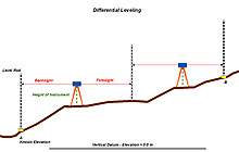
This diagram illustrates how the elevation at one location can be determined from a location of known elevation. Click image for larger view.
For the most accurate elevations, these differences are observed by using an instrument called a “level,” which uses a telescope that has cross hairs to “sight” from a known elevation to a specially built graduated rod placed on the spot being surveyed. So, “leveling” is the act of determining the difference in elevation between any two points using a level and rods.
Leveling is basically a “leap frog” affair, with the level placed between two rodmen and their carefully held rods. Beginning the line with a rod held on a survey mark that has a known elevation, known as a benchmark, the observer takes a reading with the level (the backsight reading). The observer then turns the level and makes the foresight reading on the forward rod. The difference in the readings is the difference in elevations between the rods. The foresight rod stays in place while the level and the backsight rod move forward. With the level again in the middle, the backsight is taken, then the foresight.
In this way, elevations are transferred to points along the line until another benchmark of known elevation is tied in as a check. The elevation for the check mark is computed from the values derived from the leveling and compared to the known elevation. The comparison of values tells the level party whether to move on or to reobserve. As with all geodetic surveying, different degrees of accuracy have a different error tolerance.
As the crews survey a level line, they occasionally set a “benchmark” in the ground, typically about every kilometer along the level line. An effort is made to place these marks on stable surfaces, such as bedrock or a large boulder, where their elevation will remain constant. In some cases, metal rods are pounded deep into the ground to ensure stability of the mark.
Prior to setting, benchmarks are stamped with a unique designation, usually a combination of letters and numbers kept consistent along a particular level line; for example, A 196, B 196, C 196, and so on along the line. Once set, the benchmark, with its known elevation, can serve as a starting point for future elevation surveys.
NOAA’s National Geodetic Survey has established hundreds of thousands of these benchmarks across the United States. These marks make up a fundamental part of the National Spatial Reference System.
As with horizontal observations that produce latitude and longitude, elevations are determined in reference to a surface called a datum. In the case of orthometric heights (height above sea level), tide gauges are used to determine a vertical datum that is referenced to sea level.
