
 Surveying—Past and Present
 Instrument Diagrams
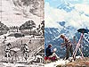 Outdoor Life
 Measuring Distances
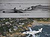 Getting There…
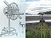 Surveying Equipment
Surveying—Past and Present
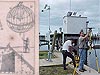
Surveying is an ancient craft. These two images compare the tools and techniques used for surveying. The "past" image is a hand-drawn sketch showing 17th century surveyors and instruments in action, extracted from a book in the NOAA Central Library rare book collection. The image on the left shows todays surveyors using global positioning system technology to take measurements.

The evolution from the optical methods depicted in the 17th century drawing on the left to global positioning system technology shown on the right has allowed hundreds of miles of evacuation routes and levees to be accurately measured at a rate unheard of in the 1600s. Left-hand image courtesy of the Treasures of the NOAA Library Collection, archival photographer Sean Linehan. Right-hand image courtesy of Davey Crockett, NGS.
That Was Then…
Surveying was particularly important in the Dutch Low Countries, where land reclamation has gone on for 2,000 years. A complex and extensive system of dykes, canals, and pumps have steadily pushed back the Zuiderzee, a body of water that was created when the North Sea broke through the dyke system in 1287, flooding fertile farmland. Enough land has been reclaimed from water that, in 1986, the Netherlands created a new province, Flevoland, from the reclaimed land.
A Dutch manual on surveying published in 1620 begins with a hand-drawn illustration of 17th century surveyors, instruments, and principles. In the illustration, the figure on the left uses an ancestor of the theodolite to sight on a rod and measure angles. At his feet lie surveying and drafting instruments, including a surveyor's chain for measuring distances. In the background, a canon and its target illustrate the use of angles and distances for artillery. Various other surveying principles are scattered across the drawing, including a globe topped by a mountain whose height is being determined.
The manual was authored by Johannes Sems (1572-1635), who practiced surveying in Leeuwarden, Netherlands, a city that would later produce legendary dancer-spy Mata Hari and artist M. C. Escher. The copy of the book from which the drawing was scanned resides in the NOAA Central Library rare book collection.
…This Is Now
Unlike the Netherlands, which is gaining land, the U.S. Gulf Coast is losing land to subsidence and erosion at a rapid pace, causing wetlands loss and flood and storm surge problems that Hurricanes Katrina and Rita emphasized with a vengeance in 2005. Through its Height Modernization Program, NOAA's National Geodetic Survey (NGS) has been working with federal, state, and local officials and the Geospatial Center at Louisiana State University since 2002 to provide accurate elevations and subsidence rates for highways and levees in Louisiana.
This image, snapped with a digital camera, depicts a very different scene than the hand-drawn artwork of Sems. In the photo, one member of an NGS survey crew sets up a Trimble Global Positioning System (GPS) antenna over a tidal benchmark, while another surveyor ensures that the receiver that will be recording the GPS data is ready for observations. That day's observations were part of an on-going effort to accurately determine the elevations of hurricane evacuation routes in southern Louisiana as well as to aid in the study of the steady sinking that is contributing to wetlands loss and salt water encroachment from the Gulf of Mexico.
About the Images
Past Image
- Date: 1600?
- Material: Hand-drawn art-work converted to etching and printed
- Source: Practijck des landmetens: leerende alle rechte ende kromzijdige landen, bosschen, boomgaerde, ende andere velden meten, (...); met eenighe nieuwe ghecalculeerde tafelen daer toe dienende, by Johannes Sems
- Instrument/technique shown: Various
Present Image
- Date: 2002
- Material: Photograph
- Source: Grand Isle, Louisiana
- Instrument/technique shown: Trimble 4000SE GPS antenna and receiver
Works Consulted
About.com. (2006). Polders and Dykes of the Netherlands. Retrieved on August 8, 2006, from http://geography.about.com/od/specificplacesofinterest/a/dykes.htm
National Library of the Netherlands. (2006). Surveying. Retrieved on August 8, 2006, from http://www.kb.nl/galerie/100hoogtepunten/044-en.html
TU Delft Library. (2006). Practijck des landmetens. Retrieved
on August 8, 2006, from http://www.library.tudelft.nl/ws/a/resources_guide/treacutesor/digital_works
/practijck_des_landmetens/index.htm
Wikipedia. (2006). Leeuwarden. Retrieved on August 8, 2006, from http://en.wikipedia.org/wiki/Leeuwarden
Related Web Sites
NOAA's National Geodetic Survey
NGS Height Modernization Program