
 Surveying—Past and Present
 Instrument Diagrams
 Outdoor Life
 Measuring Distances
 Getting There…
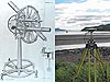 Surveying Equipment
Surveying Equipment
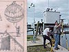
These two images depict two different tools of the trade. The left-hand image is a hand-drawn sketch showing a double repeating circle, a surveying instrument used to measure angles, owned by Coast Survey Superintendent Ferdinand Hassler. The photograph on the right shows a much different piece of equipmentan antenna used with the Global Positioning System (GPS) to receive signals broadcast from GPS satellites orbiting overhead.

Hassler's repeating circles (left) were delivered from Edward Troughton of London in 1815. The antenna enhancing Alaska scenery (left) is part of a Novatel DL4 GPS system.
That Was Then…
Mary Caroline Hassler, granddaughter of first Coast Survey Superintendent Ferdinand Hassler, was obviously a skilled artist in her own right. She left several sketches of her grandfather's equipment, including the repeating circle shown here. Having two telescopes, the instrument was designed to reduce errors by repeated observations taken on all parts of the circumference of the circle.
Superintendent Hassler ordered two of these double repeating circles in 1812. One of those two original instruments has been reconstructed by the Smithsonian National Museum of American History and can be seen on their Surveying and Geodesy Web site.
…This Is Now
With the advent of the Global Positioning System (GPS), line-of-sight measurements of angles and distances gave way to satellite positioning. Highly accurate survey projects that once took weeks to perform can now be finished in a few hours using GPS.
In the present-day photograph, Alaska is the backdrop for the antenna of a Novatel DL4 GPS system used by a private hydrographic survey company.
About the Images
Past Image
- Date: 1820
- Material: Hand-drawn sketch converted to engraving for publication
- Source: Treasures of the NOAA Library Collection, archival photographer Sean Linehan, NOS, NGS
- Instrument/technique shown: Ferdinand Hassler's repeating circles
Present Image
- Date: 2006
- Material: Photograph
- Source: John Oswald, NOAA (retired)
- Instrument/technique shown: GPS antenna
Works Consulted
Smithsonian Virtual Surveying Instrument Collection. (2006). Repeating Circle. Retrieved September, 2006, from http://americanhistory.si.edu/collections/surveying/type.cfm?typeid=16
Smithsonian Virtual Surveying Instrument Collection. (2006). Repeating Circle. Retrieved September, 2006, from http://americanhistory.si.edu/collections/surveying/object.cfm?recordnumber=747480
Related Web Sites
NOAA's National Geodetic Survey
Smithsonian National Museum of American History: Surveying and Geodesy