Electronics and Water Sometimes Do Mix: Advanced Technologies for Surveying Living Marine Resources
NOAA's National Marine Fisheries Service is dedicated to the stewardship of living marine resources through science-based conservation and management and the promotion of healthy ecosystems. Fisheries scientific research and technology development activities, including biology, ecology, economic and social sciences, oceanography, management of scientific information, engineering, and other disciplines, play an important role in helping NOAA fulfill its conservation and management mission for living marine resources.
Imagine your job is to determine the abundance of the roughly 200 different tree species in the U.S. First, you would identify each tree species. Once you can differentiate the trees, you could start counting them. Difficult job, right? Now imagine that the trees have behavioral traits that allow them to move from city to city or even across the country over days to weeks to months. Not difficult enough? Add a layer of fog so that you can only see a few feet in front of you. In tracking plant and animal species in the ocean, NOAA scientists face essentially this challenge, which gives you a sense of the breadth and complexity of fulfilling NOAA’s living marine resources stewardship responsibility.
This article looks at how science and technology are integral in helping NOAA meet this stewardship responsibility today and how science and technology will continue to help NOAA protect our nation’s living marine resources well into the future.
Polling the Oceans
Counting the number of animals in the oceans is a daunting task. NOAA has this responsibility and presently provides information on the abundance and geographic distribution of nearly 1,000 species of fish, marine mammals, and sea turtles in U.S. marine waters. This mission is made more complex by the sheer expanse of U.S. waters: at 3.4 million square miles, the area of U.S. territorial waters is nearly equivalent to the land area of the United States.
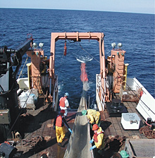
Midwater trawl coming on board the fisheries research vessel Delaware II. The trawl catch is used to verify the species composition of acoustic backscatter and for biological information such as fish length, weight, maturity, age, sex, and diet. Click image for larger view.
Rather than attempt to count every marine organism (akin to the U.S. Census) in the oceans, NOAA systematically samples ecosystems (much like political polling) and relies on the statistical science of population dynamics. NOAA divides the oceans into discrete geographic areas, conducts surveys in those areas to estimate numbers, and then uses these data to make statistical estimates of the actual population size of the species under study.
To conduct these surveys, NOAA uses a variety of ships, submersibles, and stationary platforms (e.g., buoys) to put scientists and their instruments in close proximity to the marine species under investigation. NOAA’s fishery survey vessels are the primary platforms used for living marine resource and habitat assessments. These fishery survey vessels have a combination of conventional nets and other fishing gear and advanced electro-optical sampling technologies to conduct ecosystem monitoring and research.
Looking to the Future
Because living marine resource managers are precipitously increasing demands for ecological data, NOAA continues to investigate and develop advanced sampling technologies to provide cost-effective, accurate, and timely scientific information. Some of the more promising technologies NOAA will investigate over the next 20 years to advance its world-class marine ecosystem surveys are:
- active acoustics
- passive acoustics
- optical technology
- autonomous underwater vehicles
Each of these technologies is discussed in detail below.
Active Acoustics
Underwater acoustic technology was originally developed in the early 1900s to detect objects such as submarines and icebergs in the water and to map the ocean depths. The commercial fishing industry subsequently used the technology to more efficiently locate schools of fish. Today, underwater acoustic instrumentation is used to assess fish stocks and map sea floor habitats.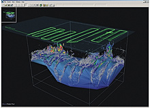
This image shows the three-dimensional distribution of widow rockfish schools overlayed on bathymetry (blue surface) off the coast of Oregon, as observed using scientific echosounders. The green lines represent the vessel track and the acoustic energy is represented on a color scale with grey denoting low fish density to red denoting high fish density. Click image for larger view.
Active acoustics methods introduce short sound bursts (i.e., pings) into the water and record the returning echoes. This is very similar to how whales, dolphins, and bats use sound to communicate and find food. Because sound travels quickly and efficiently through water, acoustic methods allow one to “see through the fog” to detect objects in the water at distances much greater than just a few feet.
Traditional fisheries acoustic systems sample a cone-shaped volume of water (much like a downward pointing flashlight beam). Returning echoes provide information on the size, number, and potential identification of the fish.
Because of their effectiveness, many different types of acoustic methods are being developed. Multibeam sonars use a large number of sound beams to sample a large swath of the ocean in a short period of time. Broadband systems transmit many sound frequencies (similar to striking multiple piano keys simultaneously), potentially allowing fish to be identified. Sonar systems, when directed horizontally, can sample from hundreds to tens of thousands of meters. These systems also sample large areas in a short time, but as the sampling area increases, the detail of the returning information diminishes.
Ultimately, NOAA will use a combination of these acoustic systems to comprehensively sample the ecosystem.
Passive Acoustics
Oceans encompass a rich acoustic milieu, exhibiting sounds from geological and physical phenomena such as rain, waves, earthquakes, and ice break-up, as well as biological sounds produced by invertebrates, fishes, seabirds, marine mammals, and humans. Unlike active acoustic systems, passive acoustic systems merely listen and record. These systems provide detailed information on the behavior of the sound source, whether it is geologic activity at the sea floor, the seasonal mating calls of reef fishes, the echolocation sounds of foraging whales, or the presence of fishing vessels in marine protected areas. This acoustic data is compared with records of other environmental phenomena to provide insight into changes within the marine environment associated with, among other things, seasonal ocean productivity, regional and global climate variability, and human impacts.
Passive acoustic systems represent a broad, ecosystem approach to studying and conserving marine resources. Moreover, passive acoustic systems are a highly efficient and cost-effective tool to monitor physical and biological phenomena in remote locations.
NOAA will continue to develop and evaluate passive acoustic technologies to efficiently detect, record, store, and analyze sounds from the marine environment.Optical Technology
Optical technologies are used to see what is in the water column and on the sea floor.
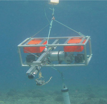
The Bottom fish Camera (BotCam) with digital video recorder, underwater video cameras, pressure housing for the electronics, and buoyancy control foam (orange blocks) is deployed by the Pacific Island Fisheries Science Center in and around coral reefs to count and measure species diversity. Click image for larger view.
Digital video and still camera technology is evolving rapidly, providing higher resolution images and greater potential to capture images in low-light environments. In addition to their stand-alone value, optical technologies are also used to verify data obtained from other remote sensing technologies (e.g., acoustics).
Optical sensors are also capable of being integrated and deployed from various platforms (e.g., towed underwater vehicles, moorings, submersibles, and remotely-operated and autonomous underwater vehicles) making them an unusual flexible underwater instrument to survey living marine resources. Advances in large-capacity hard drives and fast communication links have made these systems operationally reliable for monitoring fish in and around reefs and near the seabed.
Optical and video plankton recorders will be cost-effective, accurate alternatives to current net-type samplers. Traditional plankton identification and counting is a highly specialized, time-consuming component of marine ecosystem monitoring. Samples are collected by nets, sorted by hand, and visually identified under a microscope. Optical and video plankton recorders have the potential to reduce these labor-intensive practices via increasingly sophisticated, automated, image-recognition processes. Optical plankton recorders continuously sample small portions of the water column and record light transmission or attenuation (greater numbers of objects in the water will decrease the amount of light that passes through the water column). This technology provides a continuous record of the amount of “targets” passing by the sensor, thus improving sampling efficiency. The disadvantage of optical plankton recorders is the inability to identify targets. Video plankton recorders alleviate this problem by continuously recording images of the targets, which are subsequently visually inspected to determine species composition, a process that is becoming more automated.
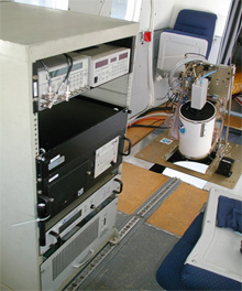
Fish LIDAR surveying mullet off Tampa Bay, Florida from a NOAA Twin Otter. Click image for larger view.
LIDAR (Light Detection and Ranging) systems mounted on airplanes transmit pulses of blue-green light down through the water column. Light, scattered by fish, zooplankton, and the sea surface is collected with a telescope. The amount and timing of returning light provides information about the density of fish and their depth.
From small aircraft, LIDAR can survey areas at 120 to 180 knots, considerably faster than ships, and with a depth penetration up to 50 meters in clear waters. As envisioned, LIDAR will compliment traditional direct sampling and acoustic surveys. In this manner, an area may be surveyed several times with LIDAR to quickly detect marine organisms, thereby freeing valuable ships to concentrate in areas of greatest biological activity. This technology has been shown to be effective in detecting and measuring large fish (e.g., salmon), small schooling fish (e.g., sardines, mackerel), and zooplankton, as well as monitoring the health of coral reefs.
Autonomous Underwater Vehicles
Established fish survey techniques such as trawl surveys and even ship-borne acoustics are often limited in ocean “boundary” areas, such as near the seashore, near the seafloor, or under ice, because these areas are difficult to access. NOAA must identify and evaluate alternate technologies to augment existing survey techniques in these areas.
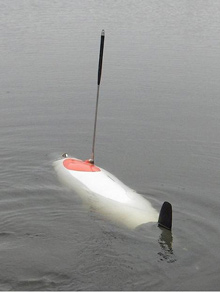
Using scientific echo sounders; stereo cameras; current profilers; and conductivity, temperature, and depth sensors, AUVs will improve the efficiency of fishery survey vessels and increase opportunities to survey in the oceanic boundary areas. Click image for larger view.
Autonomous underwater vehicles (AUVs) are programmable robotic submarine sensor platforms that can be deployed from ships, small craft, or from shore. Miniaturization of electronic components and advances in battery power allow AUVs to carry many of the same fisheries sensor suites (e.g., acoustic echosounder; current profiler; conductivity, temperature, depths sensors; stereo camera with illumination) as larger survey vessels. This allows them to sample oceanic boundary areas, which improves abundance estimates of fish and zooplankton in areas not previously accessible.
Deployment of AUVs from small craft or the shore may reduce survey costs and allow near-shore environments to be sampled, in many cases for the first time. AUV technology is emerging and rapidly advancing. AUVs are getting smaller and less expensive while accommodating more sensors and allowing longer mission durations. All of these improvements will enhance the spatial and temporal coverage needed for ecosystem observations, thus allowing for more effective fisheries management actions.
Conclusion
NOAA’s mandate to provide the highest quality scientific information for the conservation and management of the nation’s living marine resources requires continued research and development of advanced sampling technologies. Integration of these technologies, particularly remote sensing technologies like acoustics and optics, aboard NOAA’s fishery survey vessels and supplementary platforms such as AUVs, will provide more accurate and comprehensive information both spatially and temporally in a cost-effective and timely manner.
