Habitat Conservation Benefits Fish and People
NOAA and the habitat programs of the National Marine Fisheries Service manage, conserve, and enhance habitats for fish, protected species, and other living marine organisms. Habitat personnel tackle issues ranging from protection to restoration. While habitat projects undertaken by NOAA have evolved over the years, supporting healthy ecosystems remains our hallmark.
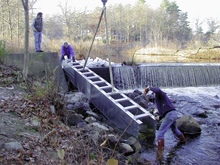
Fishways like this one on Parker River help migratory fish navigate their way around dams and other waterway obstructions. Click image for larger view.
Personnel across NOAA have a proud history of protecting and restoring healthy habitats and finding innovative ways to do so. Our evolution in methods and approaches to supporting habitats and ecosystems shows in our projects—past, present, and future. Habitat destruction in the United States is a 400-year-old issue that we strive to resolve every day.
The following examples show how habitat degradation is being dealt with by NOAA—how we endeavor to protect what remains, to restore what has been lost, and to ensure that future conservation is accomplished effectively.
Foundations—Thirty Years of Effort Brings Healthy Habitat Today
August 24, 2006, was a historic day for the Bolsa Chica wetlands in southern California. On that day, the earthen dam that severed the wetlands’ connection with the ocean was removed. The opening now allows tides to refresh the wetlands and restore the coastal ecosystem—a cycle that was disrupted at Bolsa Chica more than 100 years ago. In the coming years, planners expect dozens of species of plants, fish, birds, and other wildlife to return to Bolsa Chica for the first time since a hunting club sealed off the wetlands in 1899.
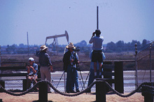
Fishwatching is a popular past-time at Bolsa Chica. Image courtesy of Peter Knapp.
After the Bolsa Chica Gun Club left the scene, various landowners developed plans for the location, a hot real estate area adjacent to Huntington Beach near Los Angeles. In the 1980s, the property owner drew up plans to build 5,700 homes, a 1,300-ship marina, hotels, and restaurants. As plans evolved and people began to better realize the value of wetlands to the environment, the number of proposed homes declined and restoring part of the land parcel as healthy wetland was discussed.
An Idea Takes Shape
The Bolsa Chica Wetlands Restoration Project began more than 30 years ago and evolved into a partnership among eight federal and state agencies. NOAA’s National Marine Fisheries Service Southwest Regional Office played an important role in this partnership, providing the scientific backing to help plan and implement restoration activities.
Experts estimate that roughly 90 percent of historic coastal wetlands in southern California have been lost through development and many wetlands that remain today are degraded. These salt marshes were home to bird life, including the endangered California least tern, and served as nurseries for commercially and recreationally important fish including California halibut. Clearly, restoring wetlands such as Bolsa Chica would be a benefit to the environment.
A Breakthrough
Activists and NOAA fought hard for a number of years to minimize development impacts and build support for restoring Bolsa Chica’s wetlands. Their breakthrough came in 1997, when the Ports of Los Angeles and Long Beach proposed major expansion of their facilities.
While the ports serve a legitimate need, California had already lost large estuarine areas to farming and urbanization. The prospect of any additional habitat loss was, and continues to be, a major issue in southern California. The ports needed to balance habitat losses from their expansion by mitigating that habitat loss through the restoration of equivalent habitat. In this instance, they agreed to provide the funding for the purchase and restoration of wetlands at Bolsa Chica.
Restoration
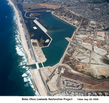
This aerial photograph shows Bolsa Chica following restoration efforts. Click image for larger view.
Project construction was the largest and most ambitious to date in southern California and featured a 600-acre restoration area. Restoration of the site took two years and included buying out oil reserves, dismantling oil extraction equipment, and removing oil-related contaminants in the soil. Throughout this project, NOAA’s National Marine Fisheries Service Southwest Regional Office played a pivotal role in the design of the restoration project, securing necessary funding from the ports, providing oversight during construction activities, and ensuring the project was completed in a cost-effective manner.
Today, the wetlands host at least 12 species of fish—in five years, scientists expect as many as 60 fish species to use the restored site. Bolsa Chica is on the rebound, thanks to a substantial investment of time and energy.
Transformations—Community-based Partnerships Create Restoration Success
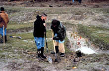
Two students dig a hole in preparation to plant potted wetland species at the Pratt Farm, Kent County, Delaware, restoration site. The Pratt Farm Riparian Restoration project, conducted as part of the Community-based Restoration Program, involved the restoration of a one-mile agricultural ditch network that drained directly into headwaters of the Chesapeake Bay.
Restoration projects conceived, supported, and funded by NOAA include community-based restoration projects. These innovative projects are characterized by partnerships among government, community organizations, industry, and individuals to achieve habitat restoration. The combination of unique skills and resources has spelled growing success for projects within the NOAA Restoration Center Community-based Restoration Program.
The success of community-based restoration is evident in the story of Town Brook. Before the Puritans arrived, Town Brook in Plymouth, Massachusetts, was—like other rivers across New England—an important habitat for herring, alewives, and other migratory fish. These fish journeyed upriver to native spawning grounds. The first colonists marveled at the numbers of fish running in rivers like Town Brook and used these fish for food and fertilizer.
Building Dams
As commerce grew, small dams built throughout New England provided power for mills and other uses. Many New England waterways were soon choked by small dams. Physical structures, impassable to migrating fish, blocked once-thriving fish runs. Fish populations declined dramatically.
New England’s river fisheries, including those at Town Brook, collapsed. By 1814, salmon runs in New England’s largest river virtually disappeared; present-day runs of salmon, herring, shad, and other anadromous fish are still dramatically reduced.
In other locations, fish ladders bypassed dams, but most fish ladders only allow passage for target species in certain life stages. The Town of Plymouth asked a fishery biologist from NOAA for help in replacing an existing fish ladder. Instead, the biologist suggested that the town make the project Massachusetts’ first ever dam removal for fish passage.
Removing the Dam
Removal of both the dam and the non-functioning fish ladder occurred in 2002, as part of a training exercise by the 368th Engineering Battalion (Heavy) of the U.S. Army Reserves. The stream was then re-graded and cobbles were added to mimic the downstream and upstream habitat and to recreate riffles and pools. Native riparian and wetland vegetation was planted along the restored stream in the spring of 2003.
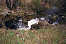
A full view of the Town Brook dam before its removal. The river is in the background. Click image for larger view.
NOAA’s Community-based Restoration Program provided technical expertise and funding for the project, while NOAA personnel assisted in the project from design to implementation to monitoring.
As part of an innovative readiness training program, U.S. Army Reservists dismantled the dam and reconstructed the streambed. This exercise provided essential training for the troops and simultaneously benefited the community and the environment.
The list of other state and local partners on the project is extensive, demonstrating strong community support. The Town Brook dam removal serves as a successful model of citizen activism achieving specific conservation goals.
Long-term Impacts
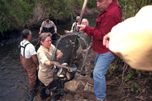
Residents of Town Brook hard at work catching fish to transport upstream beyond the dam. Click image for larger view.
One of the strengths of community-based restoration is that it is collaborative and often benefits more than just a community’s environmental needs. Scientists and restoration specialists access a spectrum of human and technological resources to increase our understanding of how to restore coastal and ocean habitats. These projects often provide added economic and social benefits. Restoration specialists agree that participating in community-sponsored projects encourages people to become lifelong stewards of the resources.
With the Town Brook dam gone, scientists predict that the number of fish reaching their upstream spawning habitat will increase exponentially, and that populations will continue to grow each year as more and more fish return to spawn.
Visions—Using Science to Support Ecosystems and Communities
Drawing on lessons learned from past experience as well as cutting-edge science and technology, NOAA’s habitat strategy for the future focuses on developing an ecosystem approach to management that can be implemented at regional and local watershed scales. More than half of the U.S. population lives and works within 50 miles of our oceans, and coastal use and development are occurring at the fastest pace in history. NOAA’s habitat management strategy must adapt to these rapidly increasing uses of coastal ecosystems while protecting and conserving natural resources for future generations. The Office of Habitat Conservation is focusing on building more resilient marine and coastal ecosystems and communities.
Today’s societal demands for new houses, more shopping, better highways, and lower taxes are often at odds with demands for clean water and air, more abundant and less-contaminated fish, and a healthier environment. NOAA is working to draw these often-competing interests together, so that human uses effectively conserve the environment.
Enhanced Resiliency
NOAA’s goal is to implement coastal programs that improve the quality of natural marine environments in a manner that also enhances the resiliency of coastal communities.
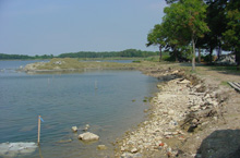
Before restoration: The Horsehead’s Living Shoreline Project removed a failing concrete/asphalt bulkhead.
What might that look like? In the Chesapeake Bay, NOAA has restored dozens of small shoreline areas with natural wetland plants, built oyster bars, and increased beach areas. In 2003, Hurricane Isabel flooded the Bay’s small tidal creeks and rivers with more than nine feet of water—many pilings and docks were completely underwater for at least one day before the water receded. After the storm, more than 90 percent of the naturally restored shorelines were intact—but many artificial, hardened shorelines were destroyed. Many coastal communities were still recovering more than two years later, with hundreds of millions of dollars of losses to individuals and the insurance industry.
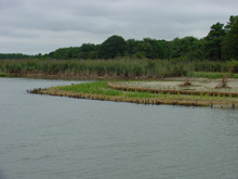
After restoration: The shoreline was stabilized using sand fill and dredge material, coir fiber logs, wetland plants, submerged aquatic vegetation, an oyster reef breakwater, and fish habitat structures. Click image for larger view.
What can be done? With NOAA’s leadership, coastal communities might review their coastal development plans, map flood zones, and examine local zoning and building codes. Buildings and utilities might be elevated to reduce chances of flooding. Shorelines can be protected with natural wetlands, beaches, and riparian forests, all of which withstand storms and flooding better than unprotected shorelines.
What are the benefits? Resilient shorelines filter sediments and chemicals that otherwise find their way into water bodies, cloud the water, and smother plants and shellfish. Resilient shorelines also filter waves that cause shoreline erosion. By reducing erosion, less eroded land enters the water, thereby reducing further degradation of water clarity or smothering of aquatic plants and animals.
Resilient marine and coastal ecosystems can withstand natural storms and floods, and are home to plants and fish that enjoy clean water and can better grow, reproduce, and survive. Coastal communities built within resilient ecosystems benefit by enjoying prosperous fishing, clean water, and reduced wave action. These communities often better survive natural storms and floods.
Conclusion
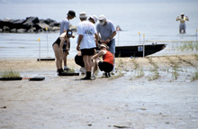
Volunteers plant smooth cordgrass, Spartina alterniflora, as part of the restoration work at the Eastern Neck Refuge, Queen Annes County, Maryland. Click image for larger view and full caption.
Learning lessons from our past, transforming to meet new challenges, and creating a vision for the future that features healthy and resilient habitat are actions that put NOAA’s National Marine Fisheries Service and its habitat programs at the forefront of supporting and enhancing habitat to support our nation’s fisheries.
