
 Thomas Jefferson's Theodolite
 Hassler's Camp
 The Great Theodolite
 Würdemann Six-inch Theodolite
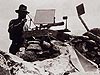 Heliotrope
 Micrometer Scale
 Theodolite Mounted on Water Tank
 Seven-inch Repeating Theodolite
 C&GS Twelve-inch Theodolite
 Wild T-4
 K&E Theodolite, Parkhurst Design
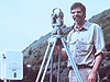 Wild T-2
 Wild T-3
 Topcon GPT-3002LW Total Station
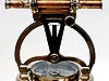
Heliotrope
A heliotrope, such as the one shown in this image, was composed of one or mirrors that reflected the sun's rays. When taking observations over long distances, the reflection off of the heliotrope provided a target on which an observer could sight his theodolite.
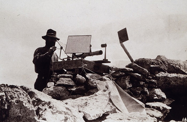
Image courtesy of NOAA, B.A. Colonna Album.
This image shows a heliotrope, one of various types of signals that were used to create a visible point for an observer using a theodolite to sight on, particularly over long distances. While observations were generally performed at night, at times the sun's rays were harnessed to give a signal during the day. Composed of one or more mirrors mounted in such a way that a beam of sunlight could be reflected in any desired direction, a peep sight or a telescope (as seen in this image) allowed the instrument to be pointed on the observing station.
In order to provide a reliable target over a survey mark for an observer to sight on, various types of signals and lights have been used over the years, including large tin cones that reflected sunlight, coal oil lamps, selenotropes for reflecting moon light, car lamps, as well as heliotropes of various designs.
Historical Reference
In 1878, Professor George Davidson, Assistant in the Coast Survey, began preparations for observing a massive quadrilateral observation involving Mounts Shasta, Lola, Helena, and several other high peaks in the western U.S. Anticipating the record-breaking lengths of the lines to be observed, Davidson made a study of the requisite sizes of heliotropes, determining that a reflecting surface of 77.5 square inches would be seen over a line 192 miles (309 kilometers) long.
With this knowledge, assistants were sent to the various mountains to establish theodolite and heliotrope stations. Deep snow, unstable boulders, and chronic altitude sickness were just a few of the obstacles overcome by the crews as they established stations on mountain peaks reaching over 14,000 feet (4,267 meters) in elevation.
Assistant B.A. Colonna later related the story of his nine days on the volcanic peak of Mt. Shasta for The Californian. Colonna's story begins with a nine-day period of time spent waiting for the summer smoke of the California valleys to clear enough to make one very important observation – the line to Mount Helena. On August 1, 1878, the smoke cleared long enough for Colonna to make the long-awaited observations. He sighted on the heliotrope at Mount Lola 169 miles (272 kilometers) away, "shining like a star of the first magnitude." Then, he turned to Mount Helena, which shone just as brightly, and so sighted across the longest observation line ever at the time – 192 miles (309 kilometers). In Colonna's words:
The French have been trying for some years to measure, trigonometrically, some lines from Spain across the Mediterranean to Algiers; they have only recently succeeded, and it has been a source of great satisfaction to French geodesists. Their longest line is 169 miles. The line from Mount Shasta to Mount Helena is 192 miles long, or 23 miles longer than their longest. And the glory is ours; for America, and not Europe, can boast of the largest trigonometrical figures that have ever been measured on the globe.
Mission accomplished and gear packed, Colonna and crew headed back down the mountain, making a rapid decent. At one point, they progressed by sliding down a long snow field on gunny sacks...or so they thought...until they spotted the gunny sacks still at the top of the field and realized that the seats of their pants had been worn right through by their giddy ride down!
- Instrument Shown: Heliotrope
- Location: Western U.S.
- Manufacture Date: Mid-1800s to mid-1900s
- Dates of Use: Mid-1800s to mid-1900
- Photo date: 1878?
Works Consulted
Colonna, B. A. (1880) Nine Days on the Summit of Mt. Shasta. Retrieved January 30, 2007, from http://www.lib.noaa.gov/edocs/shasta.html
Report of the U.S. Coast and Geodetic Survey Showing the Progress of the Work During the Fiscal Year Ending With June 30, 1880. [Electronic version]. p 37-40.