Historical Nautical Charts Collection:
New York Harbor
This collection showcases nautical charts of New York Harbor, spanning 1845 to 2006. These charts illustrate how, as development in the waters around New York City changed over time, the amounts and types of information presented on the charts also changed. The collection also explores how technology used to create nautical charts has evolved, from early charts made from hand-engraved copper plates to modern digital charts based on global positioning system technology.
The first U.S. government nautical chart was produced in 1835, by the U.S. Coast and Geodetic Survey. Today, NOAA's Office of Coast Survey holds more than 20,000 historical nautical charts and continually updates its collection of 1,000 current charts. Nautical charts are available printed on paper or as electronic navigational charts, which use computer software and electronic databases to provide navigation information.
Throughout their history, nautical charts have served to enhance safe navigation and thus have depicted the same basic types of information, including water depths and coastline shapes. That said, the complexity and number of different types of information on nautical charts have increased over time. These changes are perhaps reflective of the advent of new technologies to collect chart data, allowing greater data precision, or new technologies to produce charts, allowing the addition of finer detail and color. Also, the United States is a much different place today than it was in the 1800s, and increasing coastal development, oil and gas exploration, and channel dredging and events such as wars are also likely factors in the changing nature of information found on nautical charts.
About this Collection
This is a collection of 10 nautical charts of New York Harbor, spanning 1845 to 2006. These charts illustrate how, as development in the waters around New York City changed over time, the amounts and types of information presented on the charts also changed. The collection also explores how technology used to create nautical charts has evolved, from early charts made from hand-engraved copper plates to modern digital charts based on global positioning system technology.
Although this collection of charts was produced by NOAA's Office of Coast Survey, many nautical charts represent a compilation of information from several agencies in addition to the Coast Survey, such as the U.S. Navy and the U.S. Army Corps of Engineers.
You can browse through the charts in the collection by clicking on the links to the right or click here to view the items in the Historical Nautical Charts of New York Harbor Collection.
To better navigate this collection, review the explanations about the different kinds of information that are generally included on nautical charts.
Information on Nautical Charts: A Closer Look
The nautical chart is one of the most fundamental tools available to the mariner, providing a graphic portrayal of the waters a mariner must navigate. A nautical chart is not, however, simply a map of the coastline and ocean floor. Rather, charts include specific types of information designed to ensure safe navigation.

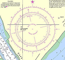
A compass rose, often found on nautical charts, appears as two rings, one smaller and set inside the other. The outside ring denotes "true" directions and the smaller inside ring represents magnetic directions. Click image for larger view and full caption.
General Information
All nautical charts include a chart number, a title, and marginal notes that provide additional information needed to interpret the chart. All charts also include information regarding position and location. Markings delineating latitude and longitude appear along the borders of charts.
On nautical charts, the top of the chart is always true north, as opposed to magnetic north, which is the direction that a compass arrow points. Most charts include a compass rose depicting the magnetic declination (variation) between magnetic and true north.
Hydrography
Hydrography is the measurement and description of the physical features of bodies of water and their coastal areas. Nautical charts illustrate hydrographic features needed by mariners to navigate a waterway.

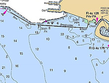
Contour lines, such as the black lines on the chart above, are lines drawn on a map connecting points of equal water depth. The numbers depict actual water depths. Click image for larger view.
The numbers on a nautical chart represent water depths. Depth contour lines are used to depict the bathymetry of the ocean floor and objects on the floor, similar to the way a topographic map shows features on land. Nautical charts produced after 1862 (when the Coast and Geodetic Survey introduced color to its charts) use colored areas to emphasize shallow water and dangerous underwater obstructions.
Water depths are determined by hydrographic surveys. Early hydrographic surveys were conducted by sounding or lead line. Although lead lines were accurate, the lines had to be lowered and read manually, a labor-intensive and time-consuming process. In the early 1930s, the development of single-beam echo sounders enabled measurement of a single water depth per sonar ping, greatly speeding the survey process and allowing more data points to be collected. In the 1970s, modern multibeam sonar swath mapping systems were developed, improving quality and coverage with multiple sounding sensors.
Today, the Office of Coast Survey conducts hydrographic surveys primarily with side scan and multibeam sonar. Multibeam sonar technology makes it possible to collect 100 percent bottom coverage of an area and creates large volumes of data.
Tides and Currents
Tables on nautical charts provide mariners with information on water levels associated with high and low tides. Information about currents, including direction and speed of flow, are also commonly found on nautical charts. Today, information on tides and currents is collected by NOAA's Center for Operational Oceanographic Products and Services.
Topography
In addition to illustrating the nature of waterways, nautical charts also depict surrounding topographic, or land, features. Charts show the shape of the coastline and symbols are often used to indicate features such as steep slopes, sand dunes, creeks, and vegetation. Human-made features, such as buildings, roads, railways, and airports also appear on nautical charts. Bridges, including bridge clearance, are clearly marked on charts as well.
Other Navigation Aids
Nautical charts use symbols to illustrate natural features of the ocean bottom and the location of natural and human-made aids to navigation such as buoys and lighthouses. Charts also take into account special conditions required for vessel passage, such as bottom clearance, shipwrecks, and obstructions. "Way points" are identified on charts to show locations where specific maneuvers, such as course changes, are necessary. Some early nautical charts even included turn-by-turn directions to help mariners navigate particularly tricky waters!
Works Consulted:
National Aeronautical Charting Office. (2006). Charting History. Retrieved June 20, 2006, from: http://www.naco.faa.gov/index.asp?xml=naco/history.
National Ocean Service. (2005). Hydrographic Surveying. Retrieved June 20, 2006, from: http://oceanservice.noaa.gov/topics/
navops/hydrosurvey/welcome.html.
Office of Coast Survey (2006). Hydrography and Hydrographic Surveys. Retrieved June 20, 2006, from: http://chartmaker.ncd.noaa.gov/hsd/hydrog.htm.
Office of Coast Survey. (2006). Office of Coast Survey: Navigational Charts.Retrieved June 20, 2006, from: http://chartmaker.ncd.noaa.gov/staff/charts.htm.
Office of Coast Survey. (2005). What is the difference between a chart and a map? Retrieved June 20, 2006, from: http://chartmaker.ncd.noaa.gov/staff/map-cht.htm.
Office of Coast Survey. (2004). Historical Map and Chart Collection. Retrieved June 20, 2006, from: http://chartmaker.ncd.noaa.gov/csdl/ctp/abstract.htm.
Theberge, A.E. (2001). Volume I of the history of the commissioned Corps of the National Oceanic and Atmospheric Administration: Part 1 - The Hassler legacy. Retrieved June 20, 2006, from: http://www.lib.noaa.gov/edocs/HASSLER5.htm.


