Founding the Survey of the Coast
The First American Science Agency

On February 10, 1807 Congress authorized a “…survey to be taken of the coasts of the United States…”. Soon after, President Thomas Jefferson (above) directed Albert Gallatin, the Secretary of the Treasury, to issue notice (some today may call it a “request for proposal” to use a modern term) to all interested men asking for plans of a survey of the coast.
Founding the United States Survey of the Coast on February 10, 1807, marked the beginnings of both the first science agency in an embryonic federal government and NOAA’s oldest ancestor agency. Fittingly, this took place during the administration of Thomas Jefferson, the most scientific of American presidents. Throughout its history this organization which has changed its name to the United States Coast Survey, United States Coast and Geodetic Survey (the term we will use throughout), and other similar titles helped shape the infrastructure and build the foundation of American science.
Primary Mission, First Superintendent, and Scientific Rigor
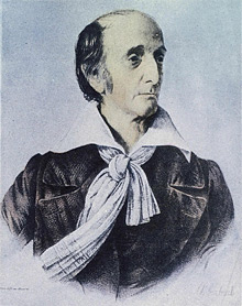
Ferdinand Hassler (shown here) responded to Gallatin’s request for plans to survey the coast. A committee of the American Philosophical Society selected his proposal from among twelve that were submitted. Hassler thus became the first superintendent of the United States Coast Survey and served until his death in 1843. Click image for larger view.
The primary mission of the Coast and Geodetic Survey was, and remains, to provide nautical charts to the American maritime community for safe passage into American ports and along our extensive coastline. Ferdinand Hassler, a native of Switzerland, was the organization’s first superintendent. He envisioned the geodetic survey of the nation, topographic maps of the shoreline and accurately positioned offshore depths that were both tied into the geodetic framework, and, ultimately, the production of nautical charts that displayed depth and shoreline data.
Hassler’s vision demanded unswerving devotion to accuracy, precision, and scientific integrity. It required expertise in mathematics, physics, metrology (the science of measurement), geodesy (precise land surveying that accounts for the shape of the Earth), topography, hydrography, and cartography. Producing nautical charts required the skills of engraver, artist, and printer. Hassler either trained or recruited individuals with these skills and invented the first modern science agency, the Coast and Geodetic Survey, that incorporated, processed, and integrated geographic data from numerous diverse sources for making the nautical chart.
A Period of Enormous Growth

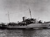
Alexander Dallas Bache (background, peering through a sextant) guided the Coast Survey through a period of enormous growth during his time as second superintendent from 1843 to 1867. The Survey began regular tide observations during his tenure, and, in 1854, established a station on San Francisco Bay (above), that is now the longest continually operating tide station in the Western Hemisphere.
After Hassler’s death in 1843, Alexander Dallas Bache became the second superintendent of the Coast and Geodetic Survey. Under Bache, the organization became the first government agency to conduct systematic deep sea oceanographic observations beginning with Gulf Stream observations in 1845; it commenced regular tidal observations; it became the first geophysical agency by starting geomagnetic observations; and, it was the first to conduct physical oceanographic studies of harbors and estuaries. The Coast and Geodetic Survey under Bache also followed the flag to new United States territory along the Gulf and West coasts. It surveyed new harbors for commerce and defense. This pioneering aspect of Coast and Geodetic Survey work continued when the U.S. acquired Alaska, the Philippines, Caribbean islands, and Hawaii.
Influence and Impact on American Science

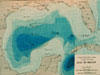
Coast and Geodetic Survey personnel developed the first realistic bathymetric map of any oceanic basin (above) from 3,000 soundings taken on the Survey Steamer Blake between 1873 and 1875 in the Gulf of Mexico. Click image for larger view.
The Coast and Geodetic Survey influenced formation of the American science community as well the early work of the American Association for the Advancement of Science and the formation of the National Academy of Sciences with Bache as its first president. The Coast and Geodetic Survey was also present when the Weather Bureau formed in 1870 as weather scientists sought its expertise to set up the country's first weather observer network. The Commission of Fish and Fisheries, founded in 1871 and now NOAA’s National Marine Fisheries Service, used its ships and expertise in early offshore scientific cruises as well. This influence continued into the twentieth century when the Bureau of Standards formed from an office within the Coast and Geodetic Survey. Later it played a significant role in forming the American Geophysical Union.
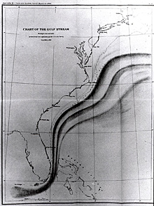
The Coast Survey was the first government agency to conduct systematic oceanographic studies of the Gulf Stream beginning in 1845. The studies integrated oceanography, marine geology, and meteorology. Click image for larger view.
The impact that the founding of the Coast and Geodetic Survey has had on the NOAA of today is immeasurable. Its core missions remain within various offices of NOAA including the Office of Coast Survey, the National Geodetic Survey, the Center for Operational Oceanographic Products and Services, and the Office of Marine and Aviation Operations making the NOAA of today the descendant of the oldest scientific agency in the federal government. More significantly, the Coast and Geodetic Survey, by serving both commerce and science, has provided the model on which multiple federal agencies are built today. Its responsibility to map the coastline of the United States led to a massive undertaking that required sustained manpower, scientific innovation, and the natural curiosity and dedication of many. Those same characteristics led the agency to pursue ever broader spheres of knowledge and helped build the organization now known as NOAA.