Understanding Climate through Modeling
Climate models use mathematical formulas run by computers to simulate the Earth's climate. Such tools allow scientists to manipulate and thus better understand the physical, chemical, and biological processes that influence climate. NOAA has been at the forefront of climate modeling, developing the first-ever model that coupled oceanic and atmospheric parameters into a single model. Since then, NOAA has continued to lead the way in developing models needed to understand our Earth system.
Climate models are critical tools for improving our understanding and predictions of the behavior of the atmosphere, the oceans, and the climate system. Since we can not recreate the Earth's atmosphere in a test tube in order to run experiments, scientists use computer-based simulations known as "general-circulation models" to study the chemical, biological, and physical processes that drive climate. These models rely on mathematical formulas to simulate the complexities of the atmosphere, oceans, and land. These complexities include things such as exchanges of heat and moisture, the effect of volcanic eruptions on temperature patterns, the effect of melting land ice on the ocean, and the reflection of sunlight off the Earth's surface (known as albedo).

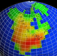
In response to increasing carbon dioxide, the climate prediction model developed by NOAA's Geophysical Fluid Dynamics Laboratory projects substantial decreases in soil moisture over most mid-latitude continental areas during summer. Click image for larger view.
Prior to development of climate models, our knowledge of oceanic and atmospheric circulations and how these circulations affect each other was based purely on theory and observation. Climate models provide the best available answers to important questions about whether the Earth's climate is changing and what may be causing the change. Models help us gain insight into climate patterns, changes, and events that occur as a result of natural variability or changes brought on by human activities, and the interplay of both. Models are also used for seasonal and long-term forecasting and for projecting high-impact features of climate such as seasonal hurricane activity and drought.
Observational climate data alone does not reveal much about cause and effect of climate change, but models allow us to determine the distinct influence of different climate features. Changes can be made to one feature in a climate model, such as warming or cooling ocean surface temperatures, to see how those changes impact climate. Today's complex climate models are used to investigate the extent to which observed climate changes may be due to natural causes or may be attributable to human activities. Models are an essential tool for estimating the effects of increasing greenhouse gases on future climate, on spatial scales from global to regional. For example, using various computer models, scientists estimate that the average global temperature will increase 2° to 6° F over the next century. For comparison, at the peak of the last ice age, the temperature was only 7° F cooler than it is today.
The History of Climate Modeling at NOAA: Coupled Ocean-Atmosphere Models

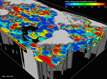
Ocean temperature anomalies at the peak of an El Niño event, simulated in a state-of-the-art climate model at NOAA's Geophysical Fluid Dynamics Laboratory. Worldwide losses resulting from the 1997-98 El Niño are estimated at $32-$96 billion. Click image for larger view.
The founding director of NOAA's Geophysical Fluid Dynamics Laboratory (GFDL), Dr. Joseph Smagorinsky, was a pioneer in combining computers and mathematical models to make extended predictions of the weather and, ultimately, of trends in the global climate. Dr. Smagorinsky was among the earliest researchers who sought to exploit new methods of numerical weather prediction to extend forecasting past one, or at most, two days. He published a seminal paper in 1962 that fundamentally changed the approach to studying physical processes that drive climate. Dr. Smagorinsky's paper was based on his research using primitive equations of atmospheric dynamics to simulate the atmosphere's circulation. Dr. Smagorinsky's work led to the extension of early weather models to include variables such as cloud cover, precipitation, turbulence, and radiation emanating from the Earth and sun.
GFDL was founded in 1955, and in 1969, the results of the first-ever coupled ocean-atmosphere general circulation model were published by two GFDL scientists, Syukuro Manabe and Kirk Bryan. NOAA was formally organized in 1970 and later in that decade, general circulation models emerged as a central tool in climate research.
GFDL's original coupled ocean-atmosphere general circulation model was the first of its kind. It included all the basic physical components of a climate model (atmosphere, ocean, land, and sea ice), but covered only one-sixth of the Earth's surface, from the pole to the equator and 120° in longitude. Its development was based on a completely new approach to scientific endeavor, departing from the independent, individual mode of enquiry. Only large-scale numerical modeling, with teams of scientists using commonly shared high-speed computers for experiments could produce answers to such extraordinarily complex problems.
The computer used to develop and run that first model was a Univac 1108 with half a megabyte of memory - not enough to store a song or a high-resolution picture today. Most watches, cell phones, MP3 players, and other electronic gadgets now have chips that process faster than the Univac 1108. It took 20 minutes to simulate one day for just the atmosphere. GFDL's supercomputer currently provides more than 100,000 times the computing power of that early computer. Pushing the limits of increasingly powerful supercomputers, efforts are underway at NOAA to use climate models with high enough resolution to produce regional or local predictions, on timescales spanning hours to centuries.
Moving Forward: Earth System Models

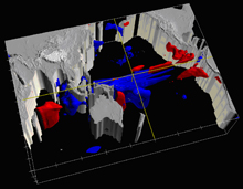
The LEVITUS data set represents objectively analyzed fields of major ocean parameters such as temperature at the annual, seasonal, and monthly time scales. Researchers at NOAA's Geophysical Fluid Dynamics Laboratory rely on such empirical results as a basis for validating model results. Click image for larger view.
Thirty-seven years after development of that first climate model, GFDL developed a new modeling infrastructure which provides a common platform for diverse research activities – from weather to seasonal prediction to human-induced climate change. This model is a prototype for the Earth System Modeling Framework, which will be used by teams of climate modelers throughout the nation to answer the pressing questions we now face on climate change.
NOAA is now poised to move beyond modeling just the physical climate system. Elements which are the building blocks of life, such as oxygen, carbon, and nitrogen, continually cycle through Earth's systems. Climate—temperature, precipitation and solar radiation—affects and, at the same time, is affected by, these cycles. The next generation of models - Earth system models - simulate the biological, geological, and chemical processes in which these elements are transported and stored. Earth system models will simulate global ecosystem dynamics and exchanges of water, energy, and carbon between plants, soil, and the atmosphere.

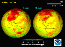
This graphic, generated using a model, shows the effect that doubling atmospheric carbon dioxide would have on surface air temperatures. Click image for larger view.
Scientists have already begun to incorporate biological and chemical processes to more realistically simulate the Earth's staggeringly complex climate system. Components of these models include temperature, humidity, wind direction and speed, and air pressure in the atmosphere; ocean surface temperature, salinity, and currents; land vegetation, soil type, soil moisture, and rivers; sea-ice concentration, thickness, and ice movement; and the interactions of a variety of biogeochemical processes within these components.
The ongoing development of Earth system models is just the latest chapter in the story of climate modeling that began a few decades ago. Continually fueled by increasing scientific knowledge, innovation, and computer power, each successive generation of climate models has evolved to be more comprehensive, more complex, and ultimately more capable of being applied to questions that are of great importance to society.
Contributed by Maria Setzer, NOAA's Office of Oceanic and Atmospheric Research
