Bringing Tsunami Forecasting into the 21st Century with Models and DARTS
Since 1948–for nearly 60 years–NOAA (and its predecessor organizations) has been the federal agency responsible for tsunami warnings in the United States and its territories. Beginning in the mid-1990s, NOAA began modernizing tsunami-warning technologies and developing inundation forecast models. The results have been vastly improved tsunami forecast and warning capabilities that save lives and protect property from the extensive devastation that tsunamis can bring. NOAA continues to expand and enhance this vital public service to the nation’s coastal communities.
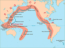
Volcanic arcs (orange) and oceanic trenches (blue) make up the Pacific Ocean basin’s Ring of Fire, an area prone to earthquakes that may trigger tsunamis. Click image for larger view and image credit.
Tsunamis are waves generated by a large disturbance of the ocean surface, primarily earthquakes. Most tsunamis occur in the Pacific Ocean (though they have also occurred in the Atlantic Ocean) and are associated with earthquake activity linked to the movement of the Earth’s crust in the region known as the “Ring of Fire.”
In 1997, the U.S. Congress created the National Tsunami Hazard Mitigation Program. This vital program, led by NOAA, sought to improve tsunami preparedness in U.S. coastal communities by improving warning guidance, mitigating potential damage, and assessing hazards. NOAA’s Pacific Marine Environmental Laboratory (PMEL) responded by building on 25 years of tsunami research to develop and deploy real-time, deep-ocean tsunami measuring technology known as DART (Deep-ocean Assessment and Reporting of Tsunamis) buoys in the Pacific Ocean and to develop improved tsunami forecast models. These two technologies enable scientists to better predict time of arrival, height, and duration of tsunamis.
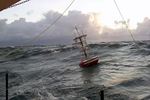
One of NOAA’s DART buoys that enable scientists to predict time of arrival, wave height, and duration of tsunamis. Click image for larger view.
The largest tsunami ever recorded, the December 26, 2004, Indian Ocean tsunami that killed over 227,000 people and caused economic losses in excess of $13 billion, hastened efforts to further improve NOAA’s tsunami forecasting capabilities. Following this catastrophe, NOAA initiated a six-fold increase in the number of DART buoy deployments and expanded their presence to the Atlantic Ocean and Gulf of Mexico. NOAA also began work to improve tsunami forecasting technologies and increase community resiliency at many U.S. coastal communities at risk of tsunami inundation.
Tsunami Forecasting: The Past
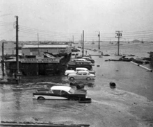
Flooded waterfront of Crescent City, California, following a 1960 tsunami generated from an earthquake off the coast of Chile. Image courtesy of the U.S. Geological Survey.
In 1946, a 7.8 magnitude earthquake in Alaska caused a devastating tsunami that killed 165 people, all but six of them in Hawaii, more than 2,000 miles away. Two years later, the nation’s Tsunami Warning System was born. From that time until recently, scientists based tsunami warnings on the location and magnitude of earthquakes in combination with a database of past earthquakes and tsunamis. The database provided scientists with some perspective on whether previous earthquakes in the area had generated tsunamis.
The warnings themselves consisted of a forecast arrival time of the first tsunami wave for selected locations around the Pacific Ocean basin that were likely to be affected. Once scientists issued a watch or warning, they monitored local tide gauges nearest to the earthquake epicenter to determine whether or not a tsunami had been generated. Warnings were then modified or cancelled as tide data became available. The time of arrival forecast was of limited value to coastal communities because it gave no indication of how much flooding would take place or how long the danger would persist. As a result, there was widespread confusion about the need to evacuate during a tsunami warning.
Tsunami Forecasting: The Present
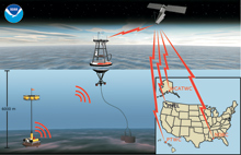
A DART station. The bottom pressure recorder, also known as a tsunamter (left), transmits data to the surface buoy (center) that, in turn, sends the data to a satellite. The satellite then distributes the data to tsunami warning centers where scientists incorporate the data into tsunami forecast models. Click image for larger view.
To forecast tsunamis, two technologies must be available in real-time: deep-ocean tsunami measurements and tsunami forecast models. NOAA’s deep-ocean tsunami measurement capability is the DART buoy. The buoy is a two-part device: a very accurate pressure sensor on the sea floor that can sense the presence of a tsunami wave and a surface buoy that receives information from the sea-floor sensor and relays it via satellite to NOAA’s Tsunami Warning Centers in Eva Beach, Hawaii, and Palmer, Alaska. With the information gathered by the DART buoys, personnel at the warning centers know whether a tsunami had been generated before it arrives at a coastal tide gauge, providing earlier warnings for affected communities. By 2001, NOAA engineers and scientists at PMEL had deployed six DART buoys in the northeast Pacific. In 2003, DART transformed from research and development status to an operational system, and moved from PMEL to NOAA’s National Data Buoy Center where tsunami experts continue to expand and maintain the array of DART buoys.
In parallel with developing the DART buoy, PMEL scientists created tsunami forecast models to use the data provided by the buoys to forecast a tsunami’s impact at specific locations. First, they use an ocean-wide propagation model to advance the tsunami energy from the source to the coastal margin. The propagation model serves as input for much higher-resolution, site-specific inundation models. Using improved information on the shape and depth of the ocean bottom (bathymetry) from other parts of NOAA and the topography of shoreline areas from the U.S. Geological Survey, scientists designed the models to predict time of arrival, duration of the tsunami, tsunami heights, and extent of flooding at specific locations.
Since 2003, DART buoys have detected six Pacific Ocean tsunamis, each of them adding to NOAA’s confidence in the accuracy of its forecast capability. PMEL scientists made experimental forecasts for tsunamis generated in the Aleutian Islands (November, 2003), Kuril Islands (November 2006 and January 2007), Tonga (May 2006), Solomon Islands (April 2007), and Peru (August 2007) for 12 U.S. coastal communities that have tide stations. When scientists compared the experimental forecasts with tide data for the six tsunamis, they found that the forecasts were 90 percent accurate.
Tsunami Forecasting: Plans and Enhancements
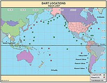
Worldwide DART buoy deployments and planned deployments as of March 2007. Click image for larger view.
The devastating 2004 Indian Ocean tsunami served as a grim reminder that the existing tsunami forecasting capability needed to be upgraded. The United States responded to this disaster by spending nearly $1 billion on rescue, recovery, and reconstruction efforts and passed a new law, “The Tsunami Warning and Education Act of 2006.” Thanks to an infusion of funding to improve the Tsunami Warning System following this catastrophe, NOAA is in the process of deploying 39 DART buoys in the Pacific and Atlantic Ocean basins (including the Gulf of Mexico and Caribbean Sea), with completion of the array expected in mid-2008. NOAA is also implementing improved forecasting capability at its tsunami warning centers.
Tsunami forecast models will continue to be developed at PMEL, transferred to the NOAA tsunami warning centers in Alaska and Hawaii and developed for more and more coastal communities. The warning centers expect to have 26 site-specific forecast models installed for the highest priority at-risk areas by late 2007. NOAA plans to have a total of 75 operational forecast models by 2013, with additional models envisioned later for smaller communities. Scientists are also implementing a system to manage the operation of the models, making it easier for a small staff to provide timely and accurate warning information to communities at risk.
PMEL engineers also have developed a prototype new generation DART buoy that is less costly to produce but, more importantly, easier and less costly to deploy and maintain. Current DART buoys require a large ship and several trained technicians to install each buoy. The new “easy-to-deploy” DART mooring is designed to be deployed by a vessel as small as a commercial fishing boat, requiring no trained personnel and only a few minutes of deployment time. The new buoy is currently in the test and evaluation phase of development. If successful, the new generation DART technology could save between 60 to 80 percent of present operations and maintenance costs.
Conclusion
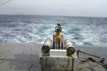
A DART bottom pressure recorder on the deck of a NOAA ship.
Well before the catastrophic 2004 Indian Ocean tsunami, NOAA recognized the need to improve its tsunami warning, assessment, and mitigation capabilities. At PMEL, activities began in the early 1970s to develop real-time, tsunami-detection buoys and conduct research on tsunami forecast models. Creating and funding the National Tsunami Hazard Mitigation Program with participation from many parts of NOAA, the U.S. Geological Survey, the Federal Emergency Management Agency, and the five Pacific U.S. states spurred forecast-development activities. Following the Indian Ocean tsunami, four of NOAA’s five operational line offices and the coastal states accelerated their efforts to improve tsunami detection, modeling, forecasting, assessment, and mitigation capabilities and to provide improved tsunami forecast and warning services to the nation. The NOAA tsunami forecast capability has shown good results for six tsunamis over the past four years and holds promise for a better tsunami warning service in the future.
Contributed by Mark Koehn and Eddie Bernard, NOAA’s Office of Oceanic and Atmospheric Research
