The Future of Environmental Satellites
NOAA currently operates 16 environmental satellites and manages the processing and distribution of millions of bits of data and images these satellites produce daily. The prime customer for the satellite data is NOAA's National Weather Service, which uses satellite data to create weather forecasts. Data are also used for applications such as climate research, forest fire detection, and search and rescue operations.
- Introduction
- Polar-orbiting Satellite System
- Geostationary Satellite R-Series
- Conclusion
- Works Consulted
Since the launch of NOAA's first satellite in 1960, NOAA has kept watch over our nation. Information from satellites has helped to increase warning times for severe weather events and increase the accuracy of weather forecasting and environmental predictions. As technology and the needs of the nation evolve, so too will environmental satellites.
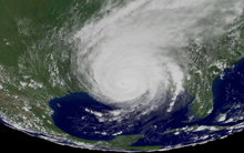
Geostationary satellites allow scientists to monitor weather patterns, such as this image of Hurricane Katrina taken by GOES-East on August 29, 2005. Click image for larger view.
Currently, NOAA is planning and developing enhancements for its two satellite programs: polar-orbiting satellites and geostationary satellites. The next generation of polar-orbiting satellites will make up the National Polar-orbiting Operational Environmental Satellite System (NPOESS) and the newest geostationary satellites will make up the Geostationary Operational Environmental Satellite R-Series (GOES-R).
This article looks at where these next-generation satellite programs will take NOAA over the next two decades.
A New Collaboration: The National Polar-orbiting Operational Environmental Satellite System
Polar-orbiting satellites observe Earth from space, following a nearly circular path around the planet. These satellites are able to monitor the entire planet and provide data for long-range weather and climate forecasts.
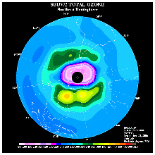
Polar-orbiting satellites allow scientists to monitor global environmental conditions. The polar-orbiting NOAA-17 satellite generated this total ozone map of the Southern Hemisphere. Click image for larger view.
NOAA currently operates the Polar-orbiting Operational Environmental Satellite (POES) program to provide daily global coverage of environmental factors useful in weather prediction and atmospheric monitoring such as cloud cover, storm location, and temperature. Today, NOAA operates five polar orbiters.
The parallel polar program in the Department of Defense is the Defense Meteorological Satellite Program (DMSP), which has been collecting weather data for U.S. military operations for almost four decades. DMSP uses low, Earth-orbiting satellites to provide the military with a view of environmental features such as clouds, bodies of water, snow, fire, and pollution.
The National Polar-orbiting Operational Environmental Satellite System (NPOESS) will combine these existing polar-orbiting satellite systems under a single national program.
The Establishment of NPOESS
NPOESS was initiated in 1994, after it was recognized that combining the existing polar systems would result in a higher performing integrated system at lower cost to the American public. By reducing the number of polar-orbiting systems from four satellite groups to three, NPOESS will provide a single, national, polar-orbiting remote-sensing capability to acquire, receive, and disseminate global and regional environmental data.
The NPOESS program is managed by a Tri-agency Integrated Program Office staffed with personnel from the Department of Defense, the Department of Commerce (NOAA), and the National Aeronautics and Space Administration.
Current Status
NPOESS is currently in the development phase. Instruments are being built and tested as the NPOESS Preparatory Project (NPP) is prepared. NPP is a research and development satellite that will reduce risks associated with the transition from POES and DMSP to NPOESS. In particular, this satellite will allow engineers to determine if the proposed instruments can be built with all requirements within the proposed cost and schedule. NPP will also demonstrate the viability of the instruments, serving as a bridge between current Earth observing satellites and the NPOESS spacecraft slated for launch late in the decade. Scientists will use NPP to study seasonal climate predictions and natural hazards such as wildfires, volcanoes, floods, and droughts.
NPOESS Benefits
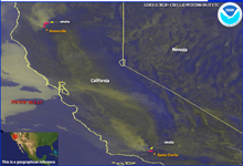
Image of two wildfires in California from GOES-West, September 25, 2006: One fire was located northwest of Santa Clarita and had burned 134,187 acres at the time this image was collected. The other fire was located northwest of Weaverville and had burned about 79,690 acres. Click image for larger view.
NPOESS will provide scientists with unprecedented access to information needed to observe, assess, and predict the total Earth system, including the atmosphere, ocean, land, and space environment. Information gained from NPOESS will benefit the civilian, scientific, and military communities, saving lives and money by improving weather prediction, forecasting and modeling, search and rescue efforts, peacekeeping activities, and disaster relief.
Over the next two decades, the benefits of NPOESS will be far-reaching and will include:
- Improving the accuracy of three- to -five day short-term weather forecasts, when combined with other observations. Today, these forecasts are 70 to 80 percent accurate; with the addition of NPOESS data, this accuracy will increase to better than 90 percent.
- Improving timely, accurate, and cost-effective severe weather warnings and forecasts by monitoring the Earth's environment. Such improved warnings and forecasts will reduce the potential loss of human life and reduce loss of property.
- Improving maritime weather forecast accuracy by supplying information and imagery on ocean winds, waves, currents, ice, and marine warnings and forecasts. Improved maritime weather forecasts will in turn improve ship routing for safety, fuel savings, and efficient operations.
- Improving our ability to monitor and detect changes in the condition of Earth's vegetative cover and land surface types. Better understanding of vegetative cover and land surface types will allow the generation of vegetation maps needed to enhance agricultural and forestry production; assessment of how natural disasters, such as fires, floods, extreme temperatures, or extended droughts, affect crops; and rapid crop health assessments to minimize the application of fertilizers while increasing crop yield and enhancing water quality in streams, rivers, and bays.
Geostationary Satellites Advance: Geostationary Operational Environmental Satellite R-Series
NOAA's Geostationary Operational Environmental Satellite (GOES) program supports the National Weather Service by transmitting pictures and data of the Western Hemisphere. Current geostationary satellites can transmit visible or infrared photos, focus on a narrow or wide area, and maneuver in space to obtain maximum coverage.
Satellites in a geostationary orbit continuously point at one particular portion of the Earth's surface. They follow the equatorial plane of the Earth at a speed matching the Earth's rotation, allowing them to "hover" continuously over one position on the surface. Because they stay above a fixed spot, these satellites provide a constant vigil for the atmospheric "triggers" for severe weather conditions such as tornadoes, flash floods, hail storms, and hurricanes.
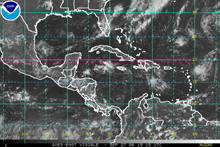
Visible satellite image from GOES-East. Click image for larger view.
In 2012, NOAA will launch the third generation of its geostationary satellites: GOES-R.
GOES-R will provide atmospheric, oceanic, climatic, solar, and space data unlike anything seen before in the history of Earth observations. This new satellite will scan the Earth nearly five times faster than the current GOES. The satellites will provide television meteorologists, private weather companies, the aviation and agriculture communities, and national and international government agencies with about one hundred times the amount of data currently provided.
This new satellite system will incorporate the following major advancements over the current GOES system:
- An advanced imager will allow GOES-R to watch a localized storm and view the entire Western Hemisphere at once. The current GOES system allows either a close view or a wide view. GOES-R will allow scientists to, for example, simultaneously watch a hurricane approaching the East Coast of the United States and a severe weather event in Arkansas.
- A Geostationary Lightning Mapper will show changes in lightning intensity and in the frequency of strikes. Being able to observe these changes will increase the accuracy of severe storm path and intensity predictions.
- The frequency of imaging of the Western Hemisphere will increase from every three hours to every 15 minutes and the frequency of imaging of the United States will increase from every 15 minutes to every five minutes. These improvements will greatly increase the accuracy of hurricane and other severe storm track predictions.
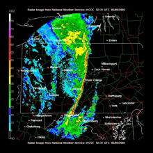
A narrow squall line nearly bisecting Pennsylvania from north to south. These lines often cause tornadoes and severe thunderstorms. Click image for larger view.
By providing more information more frequently, GOES-R will lead to several societal benefits, including safety and economic benefits to commercial, military, and general aviation; better management of energy resources; improved planning and management of ground and marine-based transportation; and better fisheries management.
GOES-R information will also lead to improved guidance for state emergency managers; cost savings for the agricultural industry due to better planning of watering and application of pesticides, herbicides, and fertilizers; and improved management of water resources and flood control.
Also, GOES-R will provide improved forecasts for traffic, weapons trajectories, ship, and plane sorties for storm avoidance, and aircraft carrier operation, all of which will ultimately lead to improved military operations.
Conclusion
The planning and development efforts for both NPOESS and GOES-R represent NOAA's commitment to the needs of those who use satellite data and to the public. With NPOESS, NOAA is well on its way to creating a system that will improve the accuracy of weather forecasts and provide search and rescue capabilities. The planned GOES-R capabilities will lead to significant improvements in detection of atmospheric moisture and improved quality of satellite derived winds, leading to improved weather prediction models.
These advancements translate into benefits for the nation and the world, allowing governments and the public to better learn from trends of the past and better prepare for what is to come.
Contributed by Mark Mulholland, Michael Tanner, and Felicia Jones-Selden, NOAA's National Environmental Satellite, Data, and Information Service
Works Consulted
NOAA's National Environmental Satellite, Data, and Information Service. (2004). Third GOES-R Users' Conference. Retrieved October 24, 2006, from: http://www.osd.noaa.gov/announcement/3rd_Conference.htm.
NPOESS Integrated Program Office. (2006). The National Polar-orbiting Operational Environmental Satellite System (NPOESS). Retrieved October 24, 2006, from: http://www.ipo.noaa.gov/index.html.
